
High-Level Discussion:
A strong trough is moving down from the Gulf of Alaska on Tuesday with unseasonably cold air and Powder. Some of the coldest temperatures of the season are possible in the PNW, with snow levels dropping to 1500 feet by Wednesday. This front drags over Interior BC and the northern Rockies, Tuesday-Thursday. SW flow migrates to NW flow initially bringing denser snow to many areas, followed by cold blower.
It has been a crazy few days as Powderchasers chased to the Sierra for one of the deepest April storms on record for the Sierra. The entire Sierra Crest scored between 25 and 43 inches from Saturday to Monday, with the highest totals being reported at Kirkwood and Palisades. Our chase took us to Kirkwood for 2 days. This was a perfect April storm coming in warm on Saturday and finishing cold on Sunday/Monday. Kirkwood expanded some new terrain on Monday, while Palisades opened the reverse traverse to hike into the Headwall. 40-plus inches fell at both Palisades and Kirkwood.
Below: 1st chair on Sunday at Kirkwood after a hectic 12-15 inch snow drive from S. Lake (Lake level snow). @Powderchasersteve via Instagram

Powder Discussion:
Looking at the models combining winds, temps, and snow, the best places to chase in the next 3 days will be the Pacific Northwest, BC (Coastal), and interior backcountry zones (Most resorts are closed) Tuesday into Wednesday. We don't see many red flags aside from gusty SW winds on Tuesday (Might keep the upper peaks of Whistler closed). This storm comes in a bit dense on Tuesday but quickly migrates to cold blower by Wednesday. (65% of snow falls slightly dense, with around 35% blower Tuesday night or Wednesday as precipitation weans).
Idaho resorts (Most are closed) and a wide area of the northern Rockies will score double digits Wednesday/Thursday initially with a weak cold front (7K snow levels). A second cold front plunges temps to near -10C at 10K feet by later Wednesday night or Thursday (Comes in denser with SW flow and migrates cold with W, NW flow). Orographics might take the turn for the Wasatch later Thursday (Wildcard).
Locations? Currently, optimism is high for the PNW (Oregon and Washington), BC, Alberta, and central and northern Idaho resorts (McCall to Sandpoint, Panhandle). Optimism is decent for the Tetons, southern and northern Montana. Utah is a wildcard with NW flow noted Thursday-Friday that could eak out higher totals than the models indicate. Beware that many resorts in the above mentioned areas are closed.
Perhaps the call will be Timberline, Bachelor, Baker, Crystal, Big Sky, Targhee, Alta/Bird (Wildcard for Friday).
Below: Snow has started at Whistler as of early Tuesday morning. Telemetry at Baker shows 2 inches as of 4 AM. Snow will continue Tuesday into Wednesday morning.

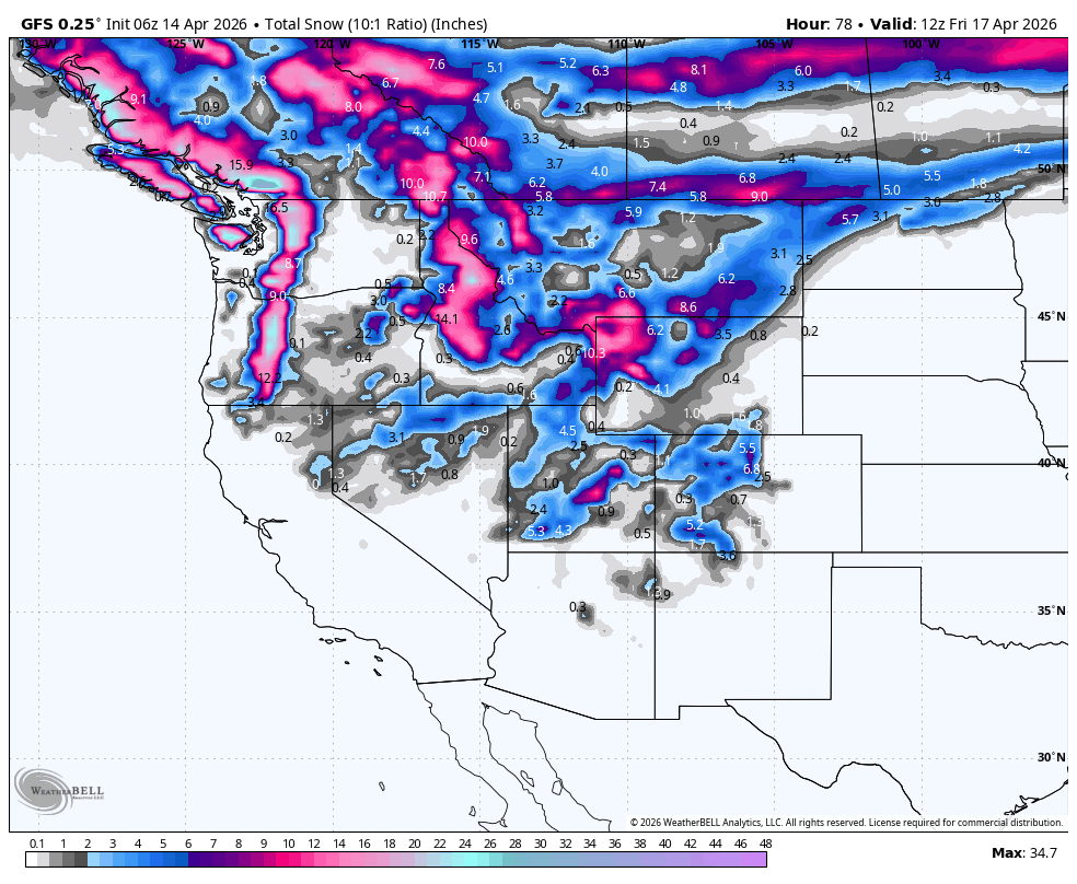
Below: Trajectory of snow from Tuesday morning to Friday. (Date and day in upper right). There is a slider storm moving into southern Utah and Colorado early on this map Tuesday. You can chase from the PNW to the northern Rockies Tuesday-Friday.

Below: Arctic Air pushes into the PNW by later Tuesday night. The cold front slowly moves over the Rockies by Thursday morning (Date-Day in upper right).

Concerns: Notice the warm front pushing in from the south over Utah and even the Tetons on Wednesday (-2 to -3C at 10K). Snow levels might push up as high as 6-7K on Wednesday PM, while snow is falling under SW flow in the Tetons (Denser snow) until the cold air moves around 9 AM on Thursday. This cold front won't reach the Wasatch until later Thursday morning. Moisture might increase for a short duration with the cold air before decreasing in the Tetons.
In the Wasatch, 3-5 inches is noted on Thursday initially, but W or NW flow Thursday PM to Friday could sneak out another 5-10 inches in the Cottonwoods, Parleys Summit, and perhaps areas of Park City (Closed).
Below: Upper-level wind speeds and direction from Tuesday to Friday. Notice the trend from SW flow (Windy periods) initially on this map for the PNW, and midweek for the Rockies. This transitions to Cold NW flow (Wednesday in the PNW) that reaches the Wasatch by later Thursday/Friday (End of this loop). The NW flow and lighter winds accompany the coldest air (-10C at 10K). Orographics will dictate snowfall during this period versus any significant moisture tap.

Below: University of Utah plumes show the warm 3-6 inches on Thursday for Alta, followed by a nice boost later Thursday into Friday with the cold air. These high-end totals are still a wildcard, but it's likley storm totals in the Cottonwoods range from 7-13 inches. Orographics Thursday PM/Friday will dictate the outcome.

Below: University of Utah ensembles showing high totals for Timberline Tuesday/Wednesday. Finally!

Below: University of Utah ensembles for Mt Baker are in the 15 or higher range (Tuesday to Wednesday).
 Chases? Tuesday/Wednesday- PNW- BC-Alberta. Thursday-Idaho/MT//WY. Friday-Wasatch?
Announcement: Ikon Rates go up after April 16th, and if you plan to renew, you can do so with the lowest rates here

Forecaster: @powderchasersteve (Insta).
Did you score powder this season as a result of our forecasts?
WE NEED YOUR SUPPORT: Please support Powderchasers with a donation below or check out our Merchandise and Concierge packages (Custom chases 1:1). These support the free forecasts each season. Feel free to support our forecast team!


