The next 7 days will feature a series of warm with briefly lowering snow levels primarily aimed at the Pacific Northwest and western Canada. It is currently snowing above 4500 in the northern Cascades and western BC. Warming periods with post-frontal precipitation will bring snow levels as high as 8K at times, followed by cooling as moisture decreases from the west. This series of warm/cold moist systems continues for most of next week. Cooler temps and a trend for storms to track further south over the Sierra and Rockies are possible in our extended outlook.
Sponsor Alert: INDY PASS just announced a pass upgrade option for a nominal fee; you can grab an extra 3 days of riding at 13 resorts. Your original 2 days can turn into 5 at those select resorts. You can still join the INDY PASS waitlist here for their next release of 26/27 passes. Check out the upgrade info here

Below: Currently snowing at upper elevations of Whistler. Snow levels will eventually rise

Below: Atmospheric Rivers (Deep water vapor) from 11/6 to 11/14. These systems will bring fluctuating mid- to high-elevation snow levels.

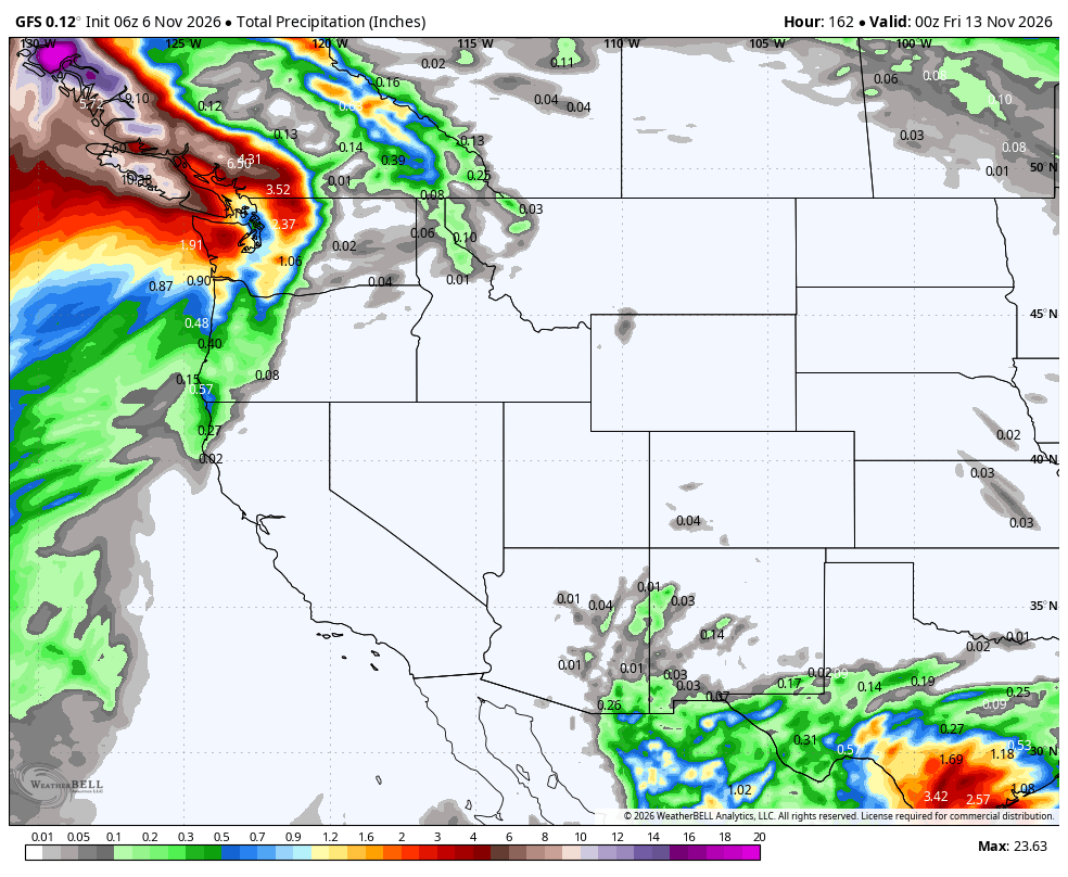
Below: Total moisture through Friday, 11/13. Signficant totals of up to 6-8 inches of liquid in western BC and 2-4 inches in the northern Cascades. Snow levels will fluctuate from 4- 8 K through the period.

PHASE 1- Friday 11/6 to Saturday 11/7
Below: Snow totals for phase 1 of this storm Friday/Saturday. Just a few inches noted for the northern Cascades and higher totals in BC (5-10). The northern coast of BC grabs very high totals at upper elevations of the Heli Terrain.

PHASE 2- SUNDAY TO MONDAY
Below: The 2nd surge of moisture comes Sunday/Monday with slightly cooler temps and a bit more snow for the northern Cascades (Baker) and even higher totals above 5K at Whistler.

EXTENDED POWDER? Colder and snowier?
Below: 11/16 to 11/22- Low pressure continues in the west, with storms possibly dipping south over the Sierra and Rockies. (Confidence is low being 7-14 days out).

11/15 to 11/20 colder
Below: Temperatures cool during the phase from 11/15 to 11/20 (Map is 4800K in Celcious). You can see very cold air at the end of this loop (11/20) over the northern Rockies.

Below: 24-hour incremental moisture totals from later next weekend (11/13) to 11/19 in week #2. The trend is for moisture to travel further south. This, combined with cooler temps, offers a glimmer of hope for the Sierra and Rockies for snowfall. Stay tuned to Powderchasers.

Below: Long-range 24-hour incremental snow totals from 11/14 to 11/20. Optimism exists; however, models that far out are subject to change (TBD). Higher confidence in colder temps and white precipitation.

Forecaster: @powderchasersteve (Instagram)
If you read our free forecasts, please consider supporting us with some of our high-quality merch in our powderchaser store. The Concierge program gets you to the deepest powder with every storm!
HELP US OUT- Please support your love of powder and our free forecasts with a donation here