Heavy snowfall with warm moist air over the PNW will rapidly transition to a colder pattern late this weekend into early next week. Moisture streams east over the Rockies with a moderate fetch noted for the Sierra Range. In the next 7 days some resorts in the west including the Sierra will nab 2-5 feet.
If chasing powder, we like the looks of the Cascades beginning north from Whistler to Baker on Sunday morning, Stevens Pass Midday Sunday with less snow to the south. Warm air initially Sunday will create some good dense layers (Much needed). Winds will be very gusty at upper elevations with the onset of this storm Saturday night to Sunday (Lift issues likely).
Arctic air will push in from the north in the PNW Sunday evening crashing snow levels from 3500 to near 200 feet by Monday. Significant dry density powder will likely fall over the Cascade Ranges with convergence zones possible setting up over Stevens or Snoqualmie Pass Sunday night. The models fill in the voids with resorts continuing to see snowfall up north pushing south into Crystal, White Pass, and most of Oregon.
Impressive totals (12-15) are showing up in these areas. The central Cascades of Washington near I-90 or Stevens Pass, Mt Baker, and northern Oregon (Timberline, Hood) appear to be the deepest with 20 plus inch storm totals.
Below: Total snowfall for the PNW through Monday night. The northern mountains are favored Sunday with moisture dropping south PM Sunday to Monday with much colder temps! The central Cascades near or north of I-90 might grab 2 feet or more.
Below: The Sierra grabs scraps with 2-7 inches possible in some areas. The models are downtrending a bit. Focus is Monday/Tuesday but it is not likely to be deep.
In Canada we expect decent totals (6-11) for Western BC, and less further inland.
In the Rockies, focus turns to Idaho, northern Montana, Tetons, Wasatch, and a broad area of Colorado.
We see some parts of the Panhandle of Idaho (Montana border), easily picking up 9-15 inches. Further west towards Brundage will also see decent totals Monday with higher amounts midweek.
The northern areas near Standpoint should grab (Selkirk Powder Cat Guides) should grab a nice refresh with plenty more by midweek. This storm comes in warm and finishes cold (Dense to blower). A very significant drop of temps is likely with the cold front.
Selkirk Powder should deliver some deep totals midweek and still has reservations available. Mention Powderchasers for free PC swag. Conditions should be epic by midweek.
For Montana significant snowfall is noted on the models on the eastern sides of Glacier National Park with moderate totals for Whitefish. Moderate totals are also likely for the Bozeman area mountains and areas north to Missoula (MSB).
The Tetons grab a storm ski day Monday (5-10) with the Wasatch on tap for PM Monday to AM Tuesday. Cold air behind the warm moist air should keep snow showers going well into Tuesday, however the precipitation will be more showery and influenced more by orographics (Cold air rising over the mountain ranges) as opposed to a moisture tap.
We can see some of northern Utah ending up with 11-15 for the Cottonwoods, 7-12 for Park City and similar totals, perhaps slightly higher for the Ogden area (Snowbasin and Pow Mow). Most of this will occur with the warmer air Monday prior to the cold front due after midnight Tuesday morning.
This might ride like a dream (Warm cushion with feathers on top )or with such a temperature drop bring frozen chunder (Gamble, but if you hit the jackpot on snow quality it could be epic).
Colorado is a bit of a wildcard with multiple mountain ranges scoring at different times with wind shifts, warm air initially followed by bitter cold temps. We like the looks of the southern mountains (San Juan Range) for Monday night through mid morning Tueday. Crested Butte can do well with these warm moist systems with SW winds. The models take the heaviest snow as far south as Wolf Creek Tuesday. We think the snow will be very dense initially until the colder air arrives later Tuesday evening. These moist systems with strong SW winds can sometimes land surprises at Breckenridge (slides into the corner of Summit County including Hoosier Pass) where moderate snow totals are possible
.
Winds shift to the NW in the western Mountains for Colorado midday Tuesday pushing more action towards the I-70 corridor. Even Steamboat is showing up a strong contender (Wildcard) for this storm. On the Front Range there is decent snow possible for the areas north of Boulder towards Rocky Mountain National Park. We need to broadcast an update as the models seem to be downtrending slightly.
Below: Colorado will likely be deepest near Crested Butte, Aspen or the southern San Juan Range (Upper elevations only). This warm storm will have a hard time accumulating at first until the cold air arrives on Tuesday. Models subsequent to this image Saturday morning have downtrended totals a bit especially north.
Where to chase?
That’s a tough question with a few highlights below. Or join our custom concierge package to get up to the minute directions on where to go for the deepest and best snow quality.
* You could chase to the PNW now and score some deep totals. There are high risks of road closures Sunday and Sunday night. Very strong winds will be evident on Sunday. This storm starts out pretty warm. Many ski areas need base building snow so it’s possible while some areas get 2 plus feet some of your favorite runs might still be closed. Things that open Tuesday could be epic (Or Wednesday openings while areas dig out).
* Chase to Idaho, Montana. or Wyoming for Monday morning and hit Utah or Colorado for Tuesday.
* Ride Utah Tuesday and chase to the PNW for the next storm.
Extended Pow - Deepness assured.
With so much going on for the short term we will broad brush the extended.
Very significant snow totals are once again showing up for the Cascades and Idaho mid-next week. Several feet of additional snow is likely. Decent totals are also showing up for Whistler. Moderate snow will be falling in the interior of BC. Snow levels are rising from nearly 0 feet to 3,000 midweek including in Canada. For the Rockies, there is lower confidence beyond this 7 day range as snow from the Sierra late next week might push east.
The Sierra is lighting up in a BIG WAY, for a 3-5 foot storm possible towards the end of next week. Likely going to be the biggest storm of the year.
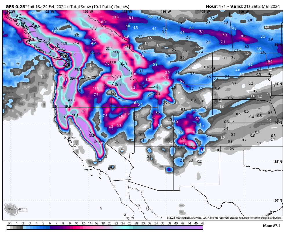
Below: 4-day snow totals from Thursday February 29 to Sunday March 3rd.

That was a lot to talk about!
Help us out!
If you want to chase powder with Powderchasers sign up for the conciergepackage for the deepest resorts to chase to and 1:1 custom forecasting with our staff. Also, if you have read this far, please donate to continue receiving these free forecasts. We appreciate the community support. You won't regret chasing with our custom forecasts. We have new swag on the Powderchasers storefront and all larger donations include it at no charge. Always free shipping when you order our stickers!
We have new Powderchasers hats fresh off production for sale currently for just $27 (Very high quality with embroider

LOTS of good deals from several of our sponsors using coupon codes and such! Up to 65% off blowout sale for Skis.com, 15% off your entire order for our newest sponsor Purl Wax, when using coupon code POWCHASERS at checkout. Fluoro free ski/snowboard wax hand poured in Colorado! Finally, coupon code POWDERCHASERS gives you free activation on your Zoleo satellite communicator! We highly recommend carrying a satellite communicator of some kind when traveling in the backcountry!
Powderchaser Steve- @powderchasersteve on Instagram