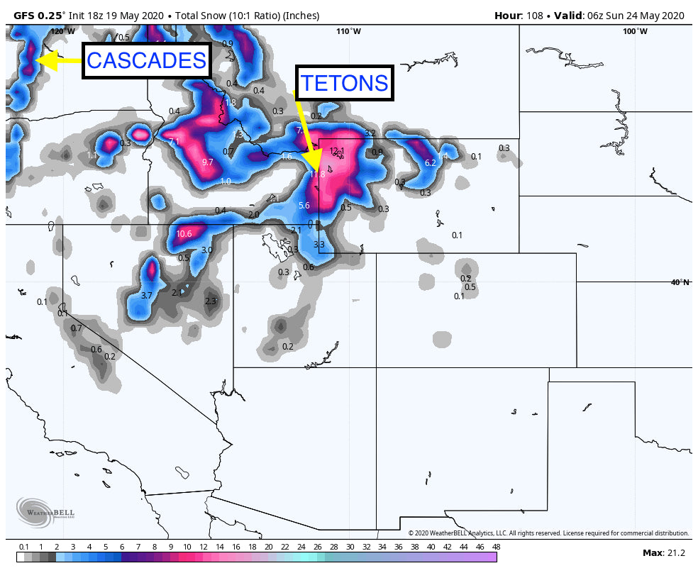
Forecast models bring cooler air to the Rockies, Pacific Northwest and interior BC this week with light snow developing as early as Wednesday night for Western Idaho, and the Tetons at upper elevations. Temperatures drop even further late this week with the best chances of accumulating snowfall increasing for much of Western Idaho, Wyoming and southern Montana Friday, perhaps continuing into Saturday. Models also show decent snowfall for Alberta near the BC border. Some snowfall is likely at lower elevations late this week, primarily on grassy surfaces or at mountain top passes especially on Friday. The bulk of the heaviest snow will be above 7500 feet.
Bottom line: Cool temps midweek, light snowfall for mountains above 8500 feet in much of far western Wyoming and Idaho. Colder temps move into Alberta and BC late this week with snow increasing over many areas of the northern Rockies Thursday night to Friday. The highest amounts are likley to fall above 7500 feet. Total snowfall from Wednesday night to Saturday may exceed 9-11 inches at the highest elevations, especially the Tetons. Some light snow may also be falling at pass levels of the Cascades this week with 2-6 inches above 5500 feet. Snow levels in the Rockies will also drop to near the bases of most ski areas by Friday with light snow at lower elevations. Light snow is also possible for the northern Wasatch ranges of Utah by late Friday.
Below: Total snowfall for the West through Saturday. Light snow and cooler temps midweek. Colder temps and moderate snowfall late week.

Below: Coldest air arrives into the Rockies Thursday night into Friday. Image is at 10K feet showing -7C or colder for many areas along the Spine of the northern Rockies from Montana to Wyoming. If you are planning outdoor travel late this week take the necessary precatutions for much colder temperatures.

Below: These Bears were spotted in Teton National Park Monday! 24 old Mom (Known as bear 399) with 4 cubs has her hands full this season. These cubs will see a taste of winter late this week. Got to love this shot! Photo: Steve Franklin

A warm up is likely for the Rockies beginning early next week. Stay safe everyone! This is obviously a very difficult time for all of us. Next season is likely to bring us back on the slopes with many changes pertaining to the Ski Industry. My gut tells me lifts will spin (Not sure about trams or gondolas), forget about cafeteria buffets, enclosed lift lines, or heavily congested areas. There is no guarentee of anything at this point. Pray for a Vaccine. When we finally do get back on the slopes that first face shot will be blissfull. Fingers crossed!
Powderchaser Steve


