As we forecasted, the last storm that stalled over the 4 corners last week provided 2 feet for the Southern Colorado mountains and a respectable 17 inches for Taos. Wolf Creek opened on Tuesday of this week for limited skiing. This is the first resort in North America to start spinning lifts. Check out our storm recap from Monday with all the details.
ANNOUNCEMENT - BREAKING NEWS FROM INDY SKI PASS.
This is not a drill! @indyskipass has announced 30+ new resorts for the upcoming season, including Loveland, CO; Innsbruck, Austria (12 resorts); 9 more resorts in Japan; and many, many more across the good old US of A. While the pass is currently only available to those on the waitlist, you can get your chance on October 28 when it becomes available to the public for just $210/mo. Sign up for the waitlist: https://www.indyskipass.com/subscribe-for-updates
Forecast:
Several systems will impact the west that will slide down from western Canada and impact the Pacific Northwest and Rockies beginning this weekend and extend into next week. We are watching 3 systems.
Below (Date/Day in upper right)- Timing of the snowfall will likely be contained to the higher peaks in western Canada this weekend with snowfall in the Cascades of Washington and Oregon due Sunday night/Monday. You can see snow filling into the PNW by Monday and eventually favoring the northern Rockies into Tuesday. The northern areas of Idaho, Montana, BC (Coast and interior), PNW, will perform well with the San Juan Range in Colorado not far behind if the models hold up. Utah is a wildcard with the Sierra an outlier for some snowfall also.

Below: Wind direction Monday/Tuesday is from the NW and provides good opportunity for many areas of the Cascades early next week (SW initially will favor Baker before moisture moves south) with many ski areas seeing snowfall and extending into the northern Rockies. In Colorado SW winds are noted below that should favor the San Juan Range again. You can see higher snowfall totals above in that region, however most mountain ranges will see impacts in Colorado.
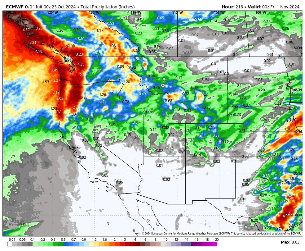
Below: Total moisture through Monday morning. Snow levels will be near 5,000 feet Sunday lowering to 3500 feet on Monday (Higher peaks will see the most snow). Pass level snow is likely with the cold front early next week. This initial push of snow for the PNW might only bring 3-6 inches to Washington and higher amounts in Oregon (Elevation dependent). The Sierra might also get teased with this first system. Snow will continue into next week with 2 more systems.
Below: 24 hour snow totals ending Tuesday night. Snow will fill in on Tuesday for areas further south including the Tetons and most of Colorado where the San Juan Range might score some decent totals again. This is moisture from Monday PM to Tuesday PM (24 hours). Some highlights in northern Montana and interior BC as well as Southern Colorado and perhaps northern New Mexico.
Below: Total snowfall through Tuesday night October 29. Models that are almost 7 days out will change so our confidence is moderate for amounts and track, with higher certainty for the pattern change. Here is the current total snowfall model run per the GFS.
Extended outlook: Low pressure systems beginning In BC this weekend track over the Cascades Sunday or Monday, and into the northern Rockies by early next week. Another system behind this sweeps into the PNW pushing south to Nevada providing another shot of snowfall for the west late next week (Halloween period). Yet a 3rd system is noted in the PNW by November 2nd (See the day and date in the upper right corner of the GIF). Unsettled conditions will continue next week.

Please support Powderchasers with a donation, Merch purchase, or sign up for our custom Concierge Powder Forecast Package where we provide 1:1 phone and email support to keep you in the deepest locations possible. Outside Magazine listed Powderchasers as in the top 3 sites with the custom concierge program. This supports us and keeps you chasing the deepest snow all winter.
You can follow us on instagram @powderchasers or Facebook.
Powderchaser Steve- @powderchasersteve on Instagram
Announcement: Alaska Backcountry Guides has a few Heli spots still open in February and March. ABG is our preferred partner for Heli skiing near Valdez. Please check out these open dates below. When you mention Powderchasers in any bookings we will provide you a free concierge weather package (1:1 forecasting) good to use for 2 years.


