It's been a fantastic chase in the past 3 days with our travels at Jackson Hole where 45 inches fell in that period. I scored the final 2 days (Denser on day 1 and blower on day 2). Utah and Colorado have scored decent numbers as well. Most of the I-70 mountains in CO picked up 6-12 inches in the past few days with Eldora near Boulder having the highest totals. The Wasatch has bluebird on Saturday with an additional 4-8 inches that fell Friday night.
Below: @powderchasersteve in the deep on Friday morning at JHMR.

The next 3 days is going to be very wet for California. Up to 4-6 inches of water might fall near the coast with 2-3 inches possible for the mountains. Mt Shasta and Mammoth might see the highest totals.
Below: Storm begins on Saturday with most of the water on Sunday morning (Map ends Sunday morning) confined to the coast. The Sierra Mountains near Tahoe may only grab moderate snow totals for Sunday morning (Timing is good). The Bad: Temps are warming Sunday with snow levels rising from lake level to around 7K. Denser surf could be decent, but it might not be too deep. Shasta to the north looks wetter.

Below: Water totals increase significantly Sunday night to the Presidents Day with at least an inch of water for the Tahoe Basin, 2-3 inches for the coastal areas, and the Mt Shasta region. With higher snow levels Monday stick to resorts with better elevation. Mammoth might be a good call with some snow at the bases. Bottom Line: Good timing for overnight snow. Density will be on the heavy side. Bring the fat skis.

Below: Temps in the Sierra are ranging from -3 to -4 C (24-26F) at 10K feet, especially Monday. Temps cool by Tuesday with some better quality snow possible albeit lighter totals. Map is Sunday to Tuesday. You can see the temps dropping to -7C by Tuesday. (Time stamp upper right). Some snow will continue.

Alaska Alert! Alyeska just passed 500 inches for the season. Alaska Backcountry Guides in Valdez (Our preferred Heli Provider) has 1 open seat for UNLIMITED VERTICAL from 2/25 to 3/2. You will have cold pow from the alpine all the way to the Valley Floor. We have high confidence for conditions. As a bonus anyone that mentions Powderchasers when booking gets a free Concierge Package good until the end of next season! Only 2 seats left!

Below: Snow moves into the Rockies early next week with peak rates likely Tuesday to Wednesday. Water totals in the Wasatch look impressive (2 inches) with perhaps 20 plus inches of snow. The Tetons should see an inch of water but it's too far out to get specific. Temps will be warm with snow levels near 7K-8K. Slightly cooler air is noted for the Tetons. Details will be ironed out in a future post or join our concierge program if you want to chase.

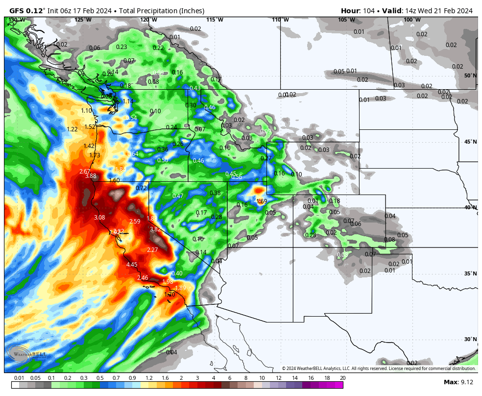
Below: Total water through Wednesday is very high for Cali extending into Oregon (Warm temps)/ Idaho is in the hunt for some moderate snowfall as well as the Tetons and eventually Colorado (TBD). Utah might be in the deeper flow, however warm temps will keep quality low with increasing AVY danger.

Help us out!
If you want to chase powder with Powderchasers sign up for the concierge package for the deepest resorts to chase to and 1:1 custom forecasting with our staff. Also, if you have read this far, please donate to continue receiving these free forecasts. We appreciate the community support. You won't regret chasing with our custom forecasts. We have new swag on the Powderchasers storefront and all larger donations include it at no charge.
Enjoy the powder, everyone! Powderchaser Steve @powderchasersteve on Insta


