
Get the boards out in the NW as snow continues in the Cascades, especially over the central and northern regions. Cooler temps and a wind shift to the West will begin to shift the heaviest snow south from the North Cascades further south. The resorts along I-90 and north up Highway 2 towards Stevens Pass should benefit from some convergence zones (Cold air forcing up over the western Cascades and producing snow from a westerly flow). Its possible that 12-15 inches fall from Tuesday to Wednesday. Further south towards the Southern Cascades amounts will be less (5-10) with minimal amounts in Oregon. Whistler in BC has scored consistent snowfall at upper elevations over the past several days, with snow levels crashing to the Valley last night.
Announcement: Get your Snow Tires as temps are cold enough for lowland snow for Whistler, Stevens Pass, Snowqualmie Pass, and the northern valley around Jackson Wyoming. Support our sponsor The Tire Rack by looking at your best wheel and tire options here. We always chase with snow tires on our specific wheel packages (Usually smaller than our summer fleet).
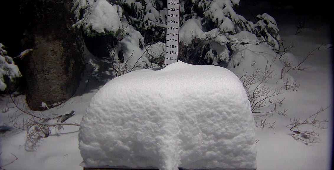
Mt Baker benefited form a moist and cool SW flow over the past several days nabbing 20 plus inches at mid mountain. The westerly flow upon us in the next 24 hours will push the highest snow totals a bit further south (Central Cascades). Whistler will continue to score in Canada. Images from Revelstoke in BC showed patrollers skiing full on powder on the upper mountain on Monday.
The Sierra storm appears to have fizzled a bit, with Mammoth reporting 7-8 inches. Models favored the southern Sierra, so its possible Kirkwood and others south of the lake did well. Even Sugar Bowl had some snow on the webcams Tuesday morning up north.
Below: Total additional snowfall through early Wednesday for the Cascades and western BC. An excess of a foot of snow will be found favoring the central Cascades and areas north. Appreciable amounts (5-10) are likely in the south Cascades. Oregon is a bit too far south for heavy snow.

Rockies-Idaho Panhandle:
Quick summary: The moisture from the Sierra pushes north into Idaho providing 4-8 inches over the northern Sawtooths (Ketchum might be too far south), and areas near Brundage. Further north, the central panhandle of Idaho and even Sandpoint will see some snow in the next 24 hours (Lighter further north). The Tetons have downgraded a bit on the model runs with our best estimate of 5-9 inches at the mid and upper elevations. There will also be snow falling at the bases of both JHMR and Targhee albeit lighter. SW winds initially will favor JHMR Tuesday (High elevation snow). Late Tuesday into Wednesday W NW winds will kick the snow levels to the valley floor. Targhee can sneak up some surprises with this wind direction so it's possible some good turns ensue. Higher amounts in Wyoming might occur on the northern end of Teton National Park near Moran where the models show up to 12 inches at upper elevations.
For Utah, while not a well organized storm (.05-1 inch of moisture) with warmer temps, their is some optimism of a semi deep powder day on Wednesday. SW winds initially with warm temps will keep snow amounts low favoring the northern Wasatch (Snowbasin), and perhaps Logan (Idaho border). Solitude sometimes also can score as well as the Uinta Range but don't expect any period with high intensity snowfall (Warm). As the winds switch to the NW late Tuesday night the Cottonwoods will see an increase in snowfall. Models are generally in the 4-8 inch range. However, looking at the Short term High Resolution Models there is a band of heavier snow noted in the Cottonwoods Tuesday night that could bring totals to the 9-12 inch range by mid Wednesday (Optimistic side). This banding of higher intensity snowfall with the switch to the NW is also highlighting some areas near Logan (Beaver) but its a gamble if I were chasing.
Below: Short term high resolution model is the most optimistic and perhaps the most trustworthy. Showing some pinks (9-10 inches) over the northern Tetons (Less further south), and over extreme Northern Utah (Idaho border) as well as the Cottonwoods (South of the Lake) and Uinta Range. Let's hope this pans out.

Below: University of Utah ensembles show a trend at Alta of around 10 inches. This would be a decent guesstimate in our opinion. Higher amounts would not surprise us, nor would 4-8. The HRR above was pretty bullish. Wednesday could be a powder day?

For Colorado decaying leftover moisture lands at some point late Tuesday night into Wednesday. Models are most bullish for the western ares from Steamboat to Telluride with less further east. NW winds can produce decent orographic lift over Vail Pass, Red Mountain pass, Telluride, and Highlands. While models show 4-8 inches it''s possible higher amounts occur in these areas. Further east towards Summit County lighter amounts are likely (3-7). The Optimist: Due to higher elevations mountain ranges many storms that show very little moisture on the models can overproduce. Let's hope that happens (Good wind direction on this storm so let's hope it overproduces).
In the extended, a trend for low pressure continues in the Pacific Northwest with a warming trend. Snow levels will rise (Warmer) as the next atmospheric river approaches mid to late week. Rain is likely at lower elevations with perhaps additional snow up top. The Rockies are likely to see a return to high pressure with some minor disturbances embedded in the flow favoring the northern regions. More details on the extended will follow on a future post.
Please join the Powderchasers Concierge to support us and to obtain very detailed forecasts (Where to chase). This program has provided many folks the deepest days of their season. You may also donate to Powderchasers here.


