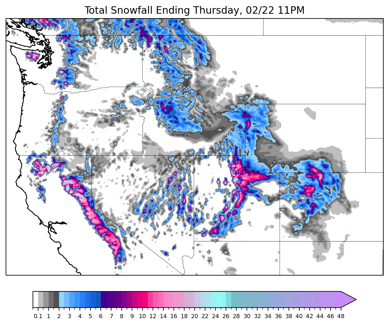
This week, two storms will push through the west.
This post is sponsored by skis.com who is offering a $10 discount code for any orders from $100 and up. Skis.com has a very comprehensive selection of gear and is family owned. Please support them with our discount code POWDERCHASERS10 on check out.

First, let's recap storm #1 by taking a look at some fresh overnight totals across the western US:
- Kirkwood: 10"
- Palisades: 7"
- Sugar Bowl: 6"
- Alta: 8"
- Jackson Hole: 3"
- Mt. Hood: 2"
Storm number 1 in CA is already wrapping up its lifecycle. As of Tuesday morning (the time of posting this forecast), most of the major precipitation is over. Below is the NOHRSC analysis for the past 24 hours in California. Multiply these values by ~10 to get the amount of snow:

During the day on Tuesday, resorts will still be picking up residual snowfall from the tail-end of this storm. Tahoe resorts will pick up about another inch Tuesday.
The Wasatch should see more, with 2-4" additional inches on Tuesday. The Tetons should pick up around an inch and resorts on the western slope of the Colorado Rockies will see a dusting Tuesday.
The second storm kicks off on Tuesday evening in California. Resorts in the western Lake Tahoe basin could squeeze out as much as 6-7" between Tuesday night and Wednesday, although totals ranging from 2-5" seem likely for Tahoe resorts. Mammoth should pick up around 4 inches.
Moving east into Utah, the precipitation will linger later into the week, lasting from Tuesday evening through Wednesday evening or Wednesday night. This storm will be taking a storm track far further south than the first one, so the best chasing will be in the Central and southern Wasatch (LCC, BCC, PCMR, DV, Sundance) or Eagle Point in the south.
During this storm, Wednesday will be the best day of skiing, with 7-11" of overnight snow for the Cottonwoods likely. Storm totals from storm #1 and storm #2 will end up between 20 and 30 inches for resorts in the Cottonwood Canyons which started on Monday.
Out of all the regions that will get snow from this storm, resorts in the Cottonwood canyons will be the best options for chasing this week due to higher elevation. Snow quality will be dense. PCMR and DV will also put up some good totals mid mountain to the summits. Expect some possible road closures for Wednesday morning (50/50 chance) in the Cottonwood Canyons.
Below is the ECMWF forecast for Utah this week:

Due to its storm track being further south, this second storm won't bring snow accumulations over a dusting or an inch or two to Idaho, Montana, and Wyoming resorts.
In Colorado, the deepest totals will be in the western and northern mountains. 5-10" for Steamboat, 1-4" for I-70 resorts, 3-6" for the central mountains, and just an inch or two for the southern mountains. Most snow will fall on Wednesday during the day with warm temps and high density.
Looking ahead, high pressure builds in the west for the weekend, steering moisture and storm energy to the north. This ridge should break down on Sunday, allowing a northern Pacific low and a cutoff low to join forces along the coast and move into the west. It's still too early to pin down specifics, but it's looking good for next week to get off to a snowy start!
Help us out!
If you want to chase powder with Powderchasers sign up for the concierge package for the deepest resorts to chase to and 1:1 custom forecasting with our staff. Also, if you have read this far, please donate to continue receiving these free forecasts. We appreciate the community support. You won't regret chasing with our custom forecasts. We have new swag on the Powderchasers storefront and all larger donations include it at no charge.
We have new Powderchasers hats fresh off production for sale currently for just $27.


