Synopsis:
We are a non-AI-generated forecast
Low pressure over British Columbia slowly moves south over Vancouver Island from Tuesday PM to Wednesday morning. Widespread 5-11 inches of snow are likely from western BC and a wide area of the western Cascade Range from Washington to Oregon. Temperatures plummet below seasonal norms by Wednesday morning, driving snow levels below 3500 feet. This low is a slow mover and could bring some surprise upside to the Cascades (Outside chance of 11-17 inches in isolated locations).
Northern Idaho and Montana, including interior regions of BC, will also grab decent freshies with this storm.
Below: Currently snowing at Whitefish

Expected storm totals
Whistler: 5-10 inches
Revelstoke: 5-10 inches
Baker: 7-10inches
Crystal: 7-12 inches
Stevens Pass: 6-12 inches
Timberline: 5-9 inches
Schweitzer: 5-9 inches
Ski Lookout: 4-9 inches
Whitefish: 5-8 inches
Bachelor: 4-8 inches
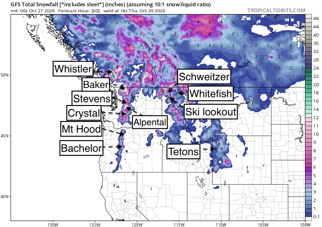
Below: Total snowfall through Thursday with highlights over the PNW, northern Idaho, and Montana. Snow peaks Tuesday night into Wednesday. Snow levels lower throughout the storm (Right Side Up)/

Below: 4800 foot temps are well below normal by late Wednesday/Thursday (-2C at 4800). Snow levels fall to near 3,000 feet at the tail end of moisture. Most resorts will see decent amounts above 4K.

Extended Forecast! November comes in Deep?
Below: 24-hour snow totals on a moving map from 11/1 to 11/3. You can see a trend for deeper pockets of snow from Idaho into most of the northern Rockies, peaking over most of Colorado by 11/2-11/3 (Date and time in the upper right corner). This could be a good storm!

Below: Low pressure in the extended forecast overspreading the Rockies in the first few days of November. This system currently looks relatively strong.

Sponsor Alert: Tire Rack has some powderchasers winter tire promotions at the link here

Forecaster: @powderchasersteve (Instagram)
Please help us out if you read our free forecasts by considering some of our high-quality merch in our powderchaser store. The Concierge program gets you to the deepest powder with every storm!
HELP US OUT- Please support your love of powder and our free forecasts with a donation here