
High Level Discussion: After several days of warm and moist air resulting in significant liquid precipitation in the Pacific Northwest and BC we finally have cold air. Unfortunately, this cold front initially is dry. New England ramps up close to double digits on Sunday/Monday with another dose into Tuesday. Finally, the northern and central PNW including BC ramp up by Tuesday/Wednesday this week. We expect 10-18 inches from Whistler extending into the northern areas of Washington. Stevens pass will grab decent totals later Tuesday night or Wednesday morning as winds shift from SW to West, however northern areas of Washington will win the game. Interior BC will see 4-8 inches from Tuesday to Wednesday.
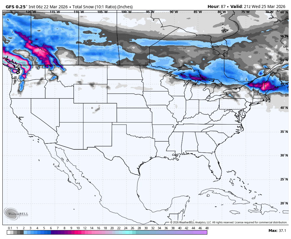
Below Total snowfall on both corners of the map. The Rockies and Sierra remain dry.

SUPPORT OUR GOLD SPONSORS


Below: New England totals by late Sunday evening favor the eastern areas of New Hampshire closest to North Conway and extend into western Maine (8-12) Northern areas of Vermont will grab 5-9 inches Sunday with additional snow falling early next week. All areas of New England will see another pulse Monday night/Tuesday with New Hampshire and Maine favored again. Timing: Storm Ski Sunday (Peak) with decent leftovers into Monday morning (Maine, and eastern New Hampshire seem favored).

Below: Snow fills into the Pacific Northwest and Western BC from Tuesday morning into Wednesday.

Below: Warm front pushes into the PNW on Tuesday afternoon with snow levels pushing up to near 3900 feet. Cold air moves in behind the initial surge of moisture on Tuesday with snow continuing albeit lighter density. This warm front also impacts Canada, however the effects will be less (Whistler grabs lower snow levels, however density will still be high Tuesday with strong upper level winds). Map: Tuesday morning into Wednesday morning (Cold initially, warming peaks Tuesday, and cold again Wednesday as moisture decreases).

Below: Snow totals through Wednesday in the PNW and western BC. The highest totals land in Canada (10-18) followed by the northern Cascades of Washington (10-18). Stevens could eek out 5-11 inches with less noted to the south towards Crystal (4-9)
 Below: Winds will be strong from the SW Tuesday pushing moisture into the north Cascades and western BC. Towards the end of this loop on Wednesday you can see the direction of the wind bars veers more westerly with the colder air. This push of west flow and colder temps Wednesday morning might ramp up the action near Stevens Pass. Winds are decreasing with this wind shift.

Please help us out if you read our free forecasts by considering some of our high-quality merchandise in our powderchaser store. or Concierge.
HELP US OUT- Please support your love of powder and our free forecasts with a donation here, or join our concierge program. We have merch on the website.
We appreciate the support.
Forecaster: Powderchaser Steve @powderchasersteve (Insta).


