Summary:
An approaching cold front is just on the doorsteps of northern Utah early Saturday. Montana, Wyoming and Utah will all see decent snow totals on Saturday/Sunday (5-14)
Forecast:
Very warm temps in the 50's impacted many ski areas of the Rockies on Friday. Jackson Hole reached the 50's at the base which currently has dropped to the low 30's as of early Saturday morning. Utah is still on the warm side of the cold front with all areas in the '50s near Salt Lake and just above freezing at most mountain top locations. Colder temps impacted southern Montana Friday night with up to 6 inches noted on the snow cameras at Big Sky (Still snowing). That might be the best location to be at for Saturday morning in the Rockies.
Below: Nearly 70 degrees in Provo Utah on Friday had me mountain biking. @powderchasersteve via Instagram

Snow will increase over the Tetons prior to the lifts opening Saturday. My forecast yesterday called for 0-1 inches at the base and up to 5 inches at the summit. Grand Targhee has an inch as of 5 AM Saturday with snow increasing. Timing has slowed, so today's forecast will decrease amounts. By last chair or tram expect 5-8 inches at the summits and less further down the mountain. Targhee might see higher amounts at the base due to the elevation advantage. It's possible that the peaks of the Tetons see higher amounts especially as snow continues into Sunday (Additional 3-5 inches). Late Saturday and early Sunday will offer your best turns (Dense snow initially finishing off with some medium density).
For Utah, rapid destabilization of the atmosphere will likely happen Saturday morning for many ski areas. The Logan area mountains will see the impacts by 8 AM and further south towards I-80 and the Cottonwoods by mid-morning. Winds are very strong Saturday morning that will decrease by mid to late morning with a wind shift to the NW. Some lift impacts are possible early Saturday. The models offer varied solutions on amounts. The best blend of the models leads me to believe that most mountains north of I-80 including Logan will grab 4-7 inches by 4 PM. Areas further south especially the Cottonwoods could approach 5-10 inches by last chairs with snow continuing into Saturday night. Models are also noting some decent snowfall for the Canyons side of Park City (Favored by NW flow). Another 3-6 inches is possible Saturday night so riding on Sunday morning could be good (Snow showers embedded in the NW flow). Snow on Saturday will start out very dense and finish colder with snow levels dropping from 9K feet to 5500. Some snow might be found on the benches above Salt Lake by Sunday morning.
For Colorado, a rather moderate event is noted for late Saturday to Sunday for many areas of northern and central zones (includes I-70 corridor). 3-7 inches are possible for these areas. Models indicate that snow showers will continue on Sunday and might enhance somewhat into Monday, especially over the Front Range. Both Sunday and Monday might offer powder for those willing to chase. Moderate or heavy snow is possible for the Front Range for Monday morning. It's possible that Eldora, Winter Park, Loveland, or even A-Basin have decent amounts for first chairs on Monday.
Below: Models picking up on some decent snowfall for the Front Range in Colorado for Monday morning. These numbers are snow totals from Saturday night to Monday morning. Most of the snow in the mountains will occur late Saturday to Sunday, while the snow closer to the Divide and Denver late Sunday to Monday.

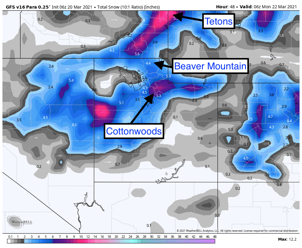
Below: Total snowfall for Utah, and Wyoming through late Sunday evening. This might be underdone, as some of the short-term high-resolution models are showing higher amounts in the Cottonwoods and the Canyons side of Park City. Storm totals above 9,000 feet could exceed 12 inches.

The Cascades scored 8 inches overnight at Mt Baker and less further south. The pattern stays progressive for the Cascades, with moderate snow likely both Saturday and Sunday. Heavier amounts are possible late Sunday into Monday with a convergence zone possible over Stevens Pass or Alpental on I-90. Conditions are continuing to improve each day, with several 3-7 inch periods this weekend. Sunday late AM to Monday AM could offer higher amounts.
Below: Winds are gusty in Utah on Saturday morning from the SW.

Below: Winds shift to the NW by late AM Saturday and decrease as snowfall intensity increases.

Extended:
The storm from the PNW early next week transitions over the Rockies by Tuesday. This will kick off another 5-11 inches for many areas from southern Montana, Wyoming, Utah, and perhaps Colorado by midweek. This system Is a bit colder and should offer better quality. While it is a fast mover and not likely to produce epic amounts of snow, it deserves watching for at least moderate amounts with some isolated heavier totals with decent quality.
Enjoy the Powder everyone!
Powderchaser Steve


