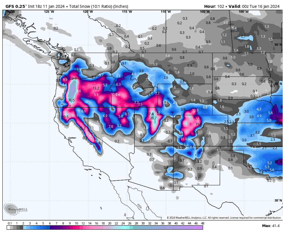
This will be a short summary since we are on the chase Thursday afternoon. The past few days has been epic in the the PNW with another 12 inches falling at Stevens Pass on Thursday in just a 4-5 hour period. Temps are cold and some snow is likely in the metro areas of Seattle.
We hit the Wasatch Range for the past few days with multiple options for 6-12 inches each day. Patrols have been able to pop lots of terrain, especially with the anticipated mega dump this weekend. Conditions reported in the Wasatch have been epic with similar reports coming from Colorado (Steamboat). Somehow Wolf Creek nabbed 21 inches (We did not see that coming). Reports from the PNW have been similar with 1-2 foot storm totals this week.
Below: @powderchasersteve via Instagram at Snowbird Resort Wednesday.

Chase- PNW
Chase options in the PNW favor Oregon or extreme southern Washington for the next few days. Total snowfall through Saturday will likely exceed 4 feet in Oregon (northern tip near Timberline or Mt Hood will likely the tip the scale).
Areas in Washington towards Stevens, I-90 Corridor, and Crystal will grab light to moderate totals Thursday evening. (Stevens would be the Friday call with a possible convergence zone and some terrain remaining closed on Thursday). Many resorts in Oregon might remain closed for safety and avalanche mitigation so use caution if you chase. This would be a risky chase for Friday/Saturday. Perhaps chase to smaller resorts with lower elevation and with trees for visibility.
The central Cascades will continue to see snow Friday/Saturday with much lower totals than Oregon. Maybe gamble on Crystal for Saturday or White Pass (5-10).
For the Sierra snow develops Friday afternoon through Saturday with 7-15 inches for many resorts. Temps will be warming with gusty winds Saturday. While it might be deep on Saturday, don't expect blower. Snow levels around 5500 feet. The trend is cold to warm (upside down snow) with definite avalanche concerns. Please stay out of the backcountry with lots of red flags (Wind and warming).
The rest of the west?
For Thursday night our highlights include the Tetons and Northern Wasatch in Utah. The Tetons will fire Thursday night into Friday with 5-10 inches of snowfall. Strong westerly winds (30-45 sustained at 10K) will impact both quality and lift operations.
The northern Wasatch Range (Beaver, Powder, Snowbasin) might sneak out some deepish powder for Friday morning in Utah. Winds are also going to be strong! Expect lift closures in the Cottonwoods with less snow.
Snow overspreads central Idaho Friday and looks deep from McCall and south. Southern areas near Boise might come out as a winner Friday/Saturday.
The Wasatch is about to get hammered with snow, wind, and some brief warming on Saturday. Heavy snowfall will migrate into the Wasatch Friday PM to Sunday. Warmer air will land base building snowfall (Medium or medium heavy densities) Saturday (expect road closures in the Cottonwoods). The temps turn colder Sunday with better quality and snow continuing for the entire Wasatch Range. Sunday and Monday might be the best picks of the week as terrain opens. I think terrain openings might be limited Saturday or Sunday in the higher elevation resorts (If you can get there). Inter-Lodge at Alta is almost certain Saturday evening and Sunday morning.
Colorado gains additional pow in the far northern areas Thursday night to Friday (Steamboat) still moisture streaming south from the Tetons (There is a trend for Wyoming Pow to often migrate south into Rout County (Northern CO). Snow picks up further south over the I-70 corridor Saturday (Moderate totals). The crank really turns on for Sunday/Monday when colder air overspreads Colorado and might bring 10-17 inches to many resorts favoring the northern and central mountains, and even including the northern San Juan Range (Telluride). Sunday will be a full on storm day with Monday offering additional pow.
Below: Total snowfall from Thursday evening to Monday night. These totals are likely going to be higher with 15:1 snow ratios in the Rockies. California snow ratios (Liquid to snow) are going to drop below 10:1. Highlights for the deepest snow will be in Oregon, followed by the Wasatch Range. Colorado also fares well in many areas with deeper pockets noted furthest north (Chase north to south Saturday- Monday). Remember- Your deepest snow is not always the best chase! We like the colder temps in the Tetons versus the Wasatch Range (less snow but still respectable). Oregon might be too deep? California warms with wind. There might not be a perfect solution. This would be a good storm to check out our long term sponsor Beaver Mountain in Northern Utah

While on the chase, we can't offer additional details. Please join our concierge program if you want to chase where we end up scoring the deepest powder almost every storm. High pressure likely next week.
Help us out!
If you want to chase powder with Powderchasers sign up for the concierge package for the deepest resorts to chase to and 1:1 custom forecasting with our staff. Also, if you have read this far, please donate to continue receiving these free forecasts. We appreciate the community support. You won't regret chasing with our custom forecasts. We have new swag on the Powderchasers storefront and all larger donations include it.
Follow us on Instagram and Facebook @powderchasers
Enjoy the powder, everyone! Remember, your deepest resort is not always the best chase. See you in the first chair somewhere.
Powderchaser Steve


