Summary:
The departing storm over Colorado and New Mexico pretty much performed as forecasted. Minimal accumulations for Ski Areas with up to 4 inches at Angel Fire (On our recommended list). The next storms for the PNW will start out as snow and finish as rain.
Forecast:
The departing storm over the Rockies skunked most areas as forecasted. Easterly winds and weak moisture grazed the Front Range of Colorado with 2 inches at Eldora and 4 inches at Angel Fire in NM. We did not have confidence for other resorts, nor expected the 3-4 inches that fell in downtown Boulder on Saturday. It seems I had more snow outside my house in Boulder than any Ski Areas that reported! Madrid Spain just recorded a record snowfall yesterday. What's happening? Uhllr the snow god needs to pay more attention to Ski Resorts!
Below: @Powderchasersteve via Instagram- Boulder was beautiful this morning with just a few seconds of blue sky poking out of the Flatirons around 8 AM.

Below: Madrid Spain! \"Bring that to our Ski Areas Please\" @scottduncanwx photo.

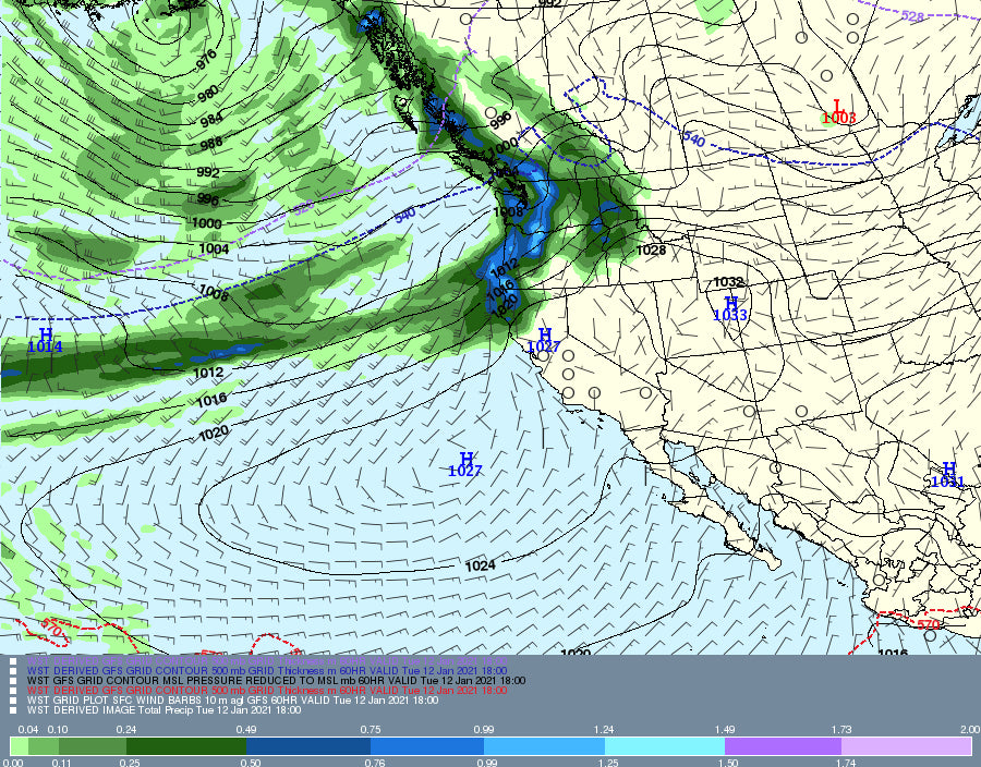
The upcoming week will feature snowfall for the Washington Cascades on Monday. The highest amounts will be near Mt Baker with snow levels near the bases. Expect 2-5 inches by lift opening Monday and another 3-7 during the day. Stevens Pass, Alpental, and Crystal will also see snowfall but lower amounts as you work south. Grab it while you can as all things spiral downwards by Monday night. Temps warm Monday night and Tuesday with an atmospheric river setting up over the PNW. Rain will be falling at all but the highest elevations of the Cascade Range on Tuesday. Moisture continues into the week for the PNW with a cold front for Wednesday. The timing might offer some opportunity for some moderate or deep snow midweek. The latter half of the upcoming week will be colder for the PNW so the opportunity may exist, however, the fire hose is decreasing.
For the Rockies, we dry out briefly with leftovers from the PNW impacting Idaho, Wyoming (Tetons), and most of northern Montana Tuesday/Wednesday. Warm temps may bring rain to some lower elevations this week in the Rockies, with snow at upper elevations. Glacier National Park, Whitefish, Lookout Pass, and the mid to upper elevations of the Tetons may benefit from this warm storm midweek. (If lucky we score some drier pow on top of a smooth cream layer).
Canada will benefit from cooler temps and another round of significant snow is likely at the upper elevations above 5500 feet. Coastal resorts of BC such as Whistler or areas north will see several feet of wet snow through midweek. Avy Danger will be on the rise!
Below: Over 121 CM of snowfall for the highest peaks of coastal BC and 35-50 CM for the interior. OH CANADA! How I miss you!

Extended:
Temps cool late in the week. Wednesday may offer some powder for the Cascades (Timing of the colder air and precipitation). We mentioned above the Tetons or areas of western Idaho above for midweek (Wet snow). The extended period brings a short burst of snow to northern Colorado by Thursday, with another more organized system for the weekend.
The weekend system does not look strong but might land some moderate snowfall for Montana, Wyoming, and Colorado (Utah will be on the southern edge). Saturday or Sunday might offer some powder days.
Below: Low pressure noted over the northern Rockies diving south into Colorado and New Mexico by Saturday.

While nothing jumps out at me regarding the following week, I will address the longer-range forecast in a future post (Covered it on Saturday's post). We might have to wait until the last week of January for any hefty dumps.
Please support our sponsors! Todays post is sponsored by TireRack who can provide you custom wheel/winter packages endorsed by Powderchasers. Click here to learn more.
Please follow me on Instagram @powderchasersteve (Nature, Weather, Travel) and our other forecaster @lstone84.
Enjoy the powder everyone!
Powderchaser Steve


