
A potent NW-flow storm slams into southern Chile Thursday night through Friday (July 24-25, 2025), dropping well over a foot of dense base-building snow on Nevados de Chillán and Corralco.
Colder air slides east on Saturday, July 26, flipping the script to light-density powder across northern Patagonia—think Chapelco and Cerro Catedral. The moisture axis then lifts north, giving the central Chilean resorts (Portillo, El Colorado, Valle Nevado, La Parva) a respectable refresh late Sunday into Monday. Expect three distinct chase windows, each with different snow flavors.
Key Points
Good: Southern Chile sees the biggest single-shot totals—up to nineteen inches at Nevados de Chillán—with snow levels below the base, ensuring all-snow to the valley floor. Patagonia scores classic blower powder Saturday (SLR ≈ 14–15) under cold temps and modest winds, while Portillo enjoys calm winds and up to nine inches of fresh by Monday morning, keeping lifts spinning and face-shots plentiful.
Bad: Friday’s southern-Chile dump arrives with strong ridge-top gusts near fifty mph, likely closing exposed lifts early. Central-Andes snow levels rise sharply Monday (peaking around nine thousand feet), so lower terminals at El Colorado/Valle Nevado may see a wet mix. Corralco’s Friday totals are deep but heavy (SLR ≈ 8), and lingering wind may slab the upper bowls.
Daily Forecast
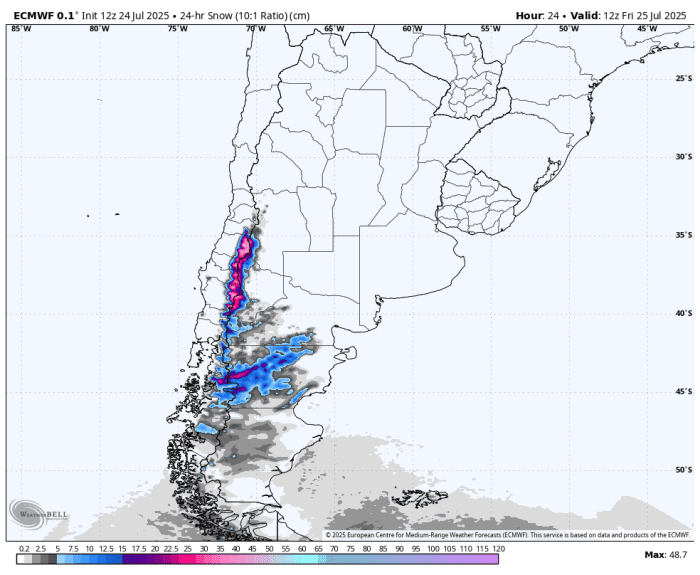
ECMWF snowfall forecast for Friday. Photo: WeatherBell/Powderchasers
Friday (July 25)
Chase south: Nevados de Chillán will stack 15–19" overnight and through the day, with snow levels near 4,700 ft—full coverage from base to summit. Winds ease by midday, but expect early wind holds. Corralco grabs 13–16" in the same window; snow is a touch heavier (SLR ≈ 8–9) yet still surfy below tree line.
Saturday (July 26)
Aim for Patagonia blower: Chapelco collects 5–7" fluff Friday night plus Saturday, SLR flirting with 14+, snow level near 1,500 ft, and light winds—pure hero powder. Cerro Catedral is a close second with 2–3" new but equally low-density snow atop a refreshed base.
Sunday (July 27)
Modest refresh, quality varies: Another pulse brings 5–8" of mid-density snow to Nevados de Chillán (snow level ~5,000 ft) and 3–6" to Corralco, both rideable though wind may drift exposed slopes. Central-Andes resorts start picking up 3–5" by last chair, setting the table for Monday.
Monday (July 28)
Central Andes reset: Portillo leads with 5–9" overnight+daytime totals (SLR ≈ 10–11), minimal wind, and snow levels just below base—smooth chalky turns on Roca Jack. El Colorado/La Parva/Valle Nevado nab 3–6" up high, but rising temps mean stay above mid-mountain for best quality. Southern zones wind down with only traces.
Regional Detailed Forecast
A deep subtropical tap funnels moisture into south-central Chile late Thursday, wringing out one-to-two inches of liquid. With 31°F surface temps and snow levels around 4,500 ft, and cash in big—dense, wind-buffed snow Thursday night easing to moderate winds by Friday afternoon. Cold advection Friday night drags snow levels to near 3,000 ft across Araucanía and Río Negro, turning new snow blower-light for and where temps dip to the upper teens. Light E-NE flow keeps winds manageable under 15 mph, preserving that dry smoke through Sunday morning.
A deep subtropical tap funnels moisture into south-central Chile late Thursday, wringing out one-to-two inches of liquid. With 31 °F surface temps and snow levels around 4,500 ft, Nevados de Chillán and Corralco cash in big—dense, wind-buffed snow Thursday night easing to moderate winds by Friday afternoon. Cold advection Friday night drags snow levels to near 3,000 ft across Araucanía and Río Negro, turning new snow blower-light for Chapelco and Cerro Catedral where temps dip to the upper teens. Light E-NE flow keeps winds manageable under 15 mph, preserving that dry smoke through Sunday morning.
Further north, the central Chilean trio (Portillo, El Colorado, Valle Nevado, La Parva) stays mostly dry until a Sunday night impulse rides the same corridor. Snow levels start near 7,000 ft but drop toward 6,000 ft into early Monday, delivering 4–9" of mid-density powder above treeline. Portillo benefits from calm NW→SE flow (<10 mph) and temperatures in the mid-twenties, while the Santiago-sector resorts face slightly warmer air and a brief 30 mph NW gust window that could ice lower lift lines. Expect Monday to ski soft up high and gluey below mid-stations.
Overall, the week favors a south-to-north progression: deep but heavy in southern Chile Friday, classic Patagonian blower Saturday, and a tidy central-Andes reset to kick off the work week.


