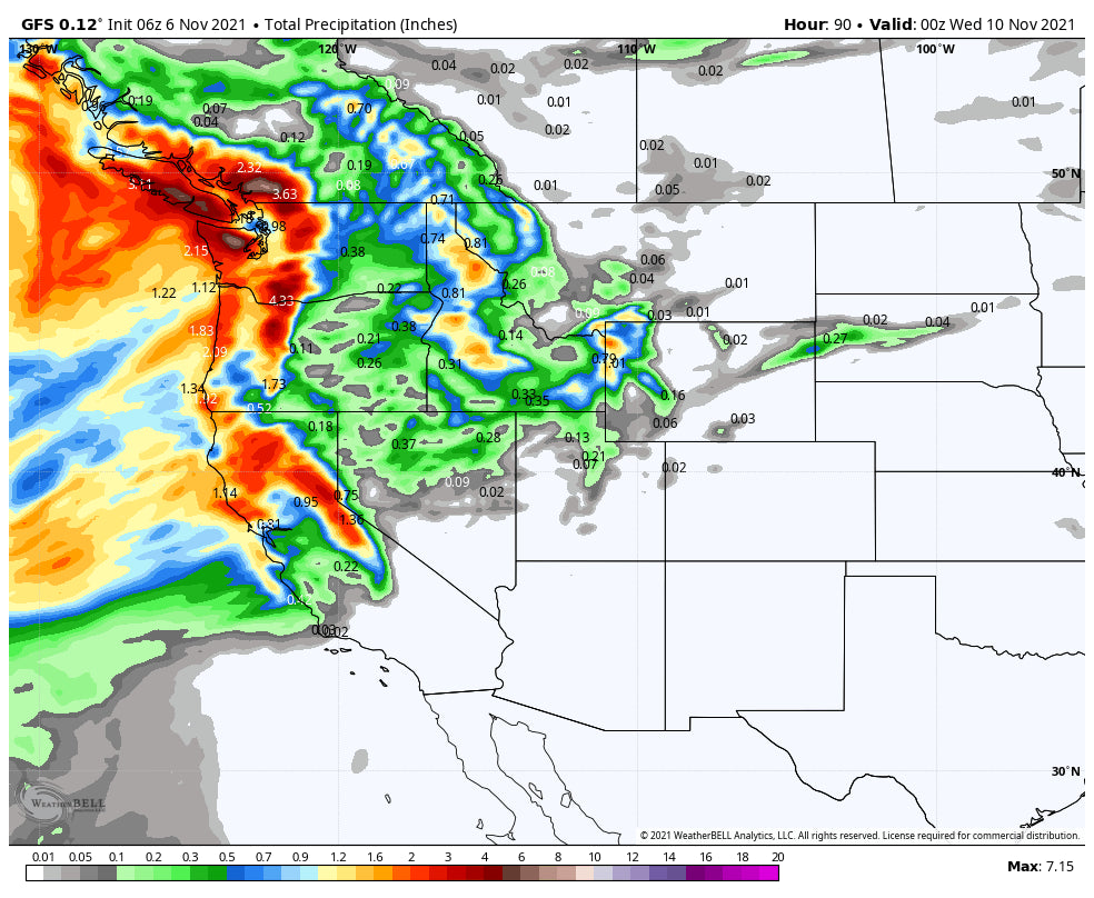
As of Saturday morning snow was falling over much of the Cascade Region of Washington and Oregon. The models are pumping decent amounts of snow through Sunday, especially the northern Cascades near Mt Baker. Looking at various snow telemetry and cams you can see 3-7 inches has fallen thus far at many Ski Areas. Snow will continue Saturday/Sunday for most of the Cascades. The highest amounts are likely to be found in the Olympics, Mount Hood, northern areas near Mt Baker, and into northern Oregon. SW flow tends to favor these regions however the entire spine of the Cascade region will see snowfall. British Columbia will score nicely in the next several days with several periods of moderate snowfall adding up to deepness at the summits, especially over Whistler.
Below: NWAC telemetry showing mid 20's at the summit of Crystal with 5 inches thus far and still snowing.

Below: Timberline Lodge Oregon Saturday morning. More snow is on the way!

Below: Whistler at 6900 feet- Roundhouse.

The models are trending with a continued unsettled pattern for the Cascades peaking this weekend and again by Tuesday/Wednesday with a 2nd storm on the horizon.
Meanwhile in the Sierra some moisture will creep into the Sierra this weekend with light to moderate snowfall above 7500 (3-6 inches). The Rockies will get teased with some light snow Saturday-Sunday, primarily northern Montana (Glacier), Yellowstone National Park (South to the northern ranges of the Tetons) and parts of central Idaho. That focus will be on Saturday night with a weak cold front. This might also bring some snow to to the roadways by Sunday morning over southern Yellowstone (This is the last weekend the park is open).
Below: In the upper right corner (Day-Time) you can see the cool air is focused in the northern regions of the west with colder air moving into the Pacific Northwest again by Tuesday next week. This cooler air combined with moisture will kick off more snow for the Cascades and most of the Northern Rockies, and Sierra.

The extended forecast looks a bit deeper.
Next week will feature another round of snowfall for the Pacific Northwest (Tuesday-Wednesday). This stream of moisture will track further south over the Sierra early next week with 6-12 inches likely for may of the Ski resorts around the Tahoe Basin. For the Rockies snow will track over western Idaho extending into the Sawtooths by Tuesday night. The models are bullish for the Tetons midweek with decent amounts at the summits by Wednesday morning. Further north into Montana amounts will be less, however some snow will be falling under SW flow into Big Sky.
For Utah the models have flipped back to a less impressive outlook with snow likely Tuesday PM into Wednesday. The focus of the highest moisture will be north into Wyoming, however with SW flow it's possible we see some surprises in the northern Wasatch (Snowbasin) or even Beaver Mountain towards the Wyoming border. The models were more impressive a few days ago so lets hope they migrate to a better solution as we approach next week.
Below: Total snowfall from storm #1 (This weekend) and storm #2 (Early to mid next week) putting down some decent numbers for the West Central Idaho (Including the Sawtooths, Tamarack, north-central Panhandle) and the Tetons. Most of the snow in the Tetons will come Tuesday or Wednesday.

For Colorado leftovers are likely mid next week that will favor the northern and central mountains. Right now, this might only be a moderate event, but being 5 days out we can certainly see some changes in the models.
Below: Total snowfall through next Thursday- Models will change so confidence is low on the longer ranges.

Enjoy the Powder everyone! If I were on the chase for white, I might head to Mt. Baker or Whistler and chase back to the Sierra or Tetons by midweek. See you on the slopes soon! Follow my adventures @powderchasersteve via Instagram.
Powderchaser Steve


