Just a quick update to summarize the current storm in the PNW and whats ahead for the Rockies and Sierra. Currently it is snowing in the Cascades with 21 inches noted at Mt Baker (Ski Area), and between 6-10 inches further south (Stevens pass in the higher end, with around 7-8 at Crystal, and Timberline (Oregon). Snow will continue on Sunday with the short term models showing another 5-11 likely for the northern Cascades and 4-7 further south. Oregon might remain too far south so additional amounts will be light. Whistler scored as forecasted!
Below: Whistler Mountain Cam Saturday night and it is still dumping.

Below: Short term high resolution models show the next 12 hours focussing snowfall over the Cascades especially in the northern Regions where another 5-11 inches is possible. The pinks are north towards Baker and further south over Mount Rainier. Rainier is shadowing Crystal somewhat. Further south it's possible White pass is scoring?

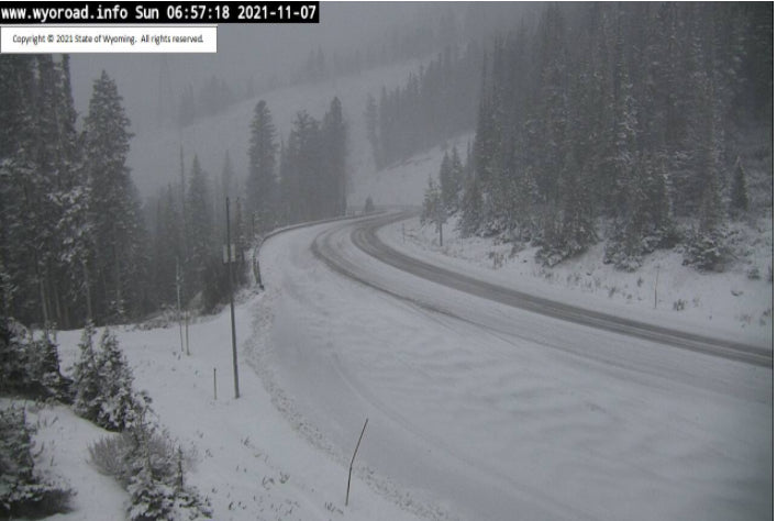
Elsewhere in the west, the Tetons grabbed around 7-8 inches at the summits of both Targhee and JHMR. Teton Pass was snow covered Sunday morning. This should taper off with perhaps an inch or 2 additional by 2PM.
Below: Teton Pass in Wyoming as of 6AM Sunday.

Announcement: Tire Rack supports Powderchasers, so if you don't already have snow tires or an extra set of wheels, please check out the packages here. In my 40 years of chasing powder I have always used snow tires (If you want first chair it's essential). Support them as a sponsor for our forecasts.
Storm #2: Slight warm-up for the PNW by Monday Night followed by cooler conditions late Tuesday to Friday. Snow will redevelop in the Cascades Monday night with another 10-12 inches likely favoring the northern regions. Light snow will move inland over the northern Panhandle of Idaho and drop south towards central and southern regions late Monday or early Tuesday. The models have downtrended amounts for Idaho so only expecting a 4-8 inch event for these areas (Northern Sawtooths, McCall, Sandpoint, etc.). Moisture drops into the Sierra around the Tuesday timeframe with wide areas of 5-10 inches. The areas around the south lake including Kirkwood might come up with higher amounts.
Wyoming and Utah score pow late Tuesday into Wednesday. Models continue to diverge a bit on the exact placement of the highest moisture. The Tetons are likely to benefit with 6-11 inches by late Wednesday. Less snow will push north into Montana. Good confidence on Teton snow.
In Utah, the American Model places most moisture at the Idaho border and north with the European pushing a bit more south (I-80 resorts or south). The likely scenario will be intense snowfall initially under SW flow favoring the northern Wasatch late Tuesday (Snowbasin or north). Winds veer to the W-NW by Wednesday which should push some higher moisture south towards Park City and the Cottonwoods. This will not be a significant storm but might land low-end double digits by late Wednesday. If the American Model proves correct resorts along or south of I-80 could come up short. Powder Mountain often scores rewards with NW winds, so if the highest moisture remains north, POW MOW might end up as a winner on Wednesday. Beaver near Logan might also do well since the highest moisture is pushing north.
Utah Bottom Line: Not a ton of moisture to work within Utah, but post-frontal winds from the NW could deliver (Wildcards). Northern areas might do better. The Cottonwoods might score a surprise with post-frontal NW flow by Wednesday morning (Wildcard).
Colorado looks favored for a moderate dump Wednesday into Thursday favoring the northern or central mountains (Steamboat to I-70).
Below: Total additional snowfall for the west from Sunday to Thursday. Note the highest amounts in the Cascades and BC, with a decent amount for the Sierra and perhaps Wyoming by late Tuesday or Wednesday. Lesser amounts are likely over Idaho, Utah and Colorado, however with post frontal NW flow some surprise totals might ensue (Cottonwoods, I-70 near Vail, Steamboat). Optimistic thinking.

Stay tuned to Powderchasers.com and sign up for our Concierge program if you want custom forecasts for the deepest days of the season (Very specific vacation planning, timing resorts, etc.).
Powderchaser Steve @powderchasersteve via Instagram


