Storm #1 is currently impacting the West, with many areas in the Sierra getting 10-15 inches of snow. Leftovers aimed at southern Utah streamed north over the Wasatch, where weak NW flow is bringing 5-9 inches to the Cottonwoods and 2-4 inches at lower elevations near Park City. Southern Utah nabbed 5-10 inches, with leftovers currently falling in southern Colorado.
Below: Additional snowfall on Saturday, focusing on the highest elevations of western BC (Highest peaks of Whistler), southern Utah, and Colorado. Snow showers will also continue in Northern Utah. Areas of northern or eastern Colorado (I-70) are outside the focus of any heavy snow.

Snowfall totals as of Saturday morning (Estimated).
Kirkwood: 13 inches
Mammoth: 14 inches
Palisades: 12 inches
Alta: 6 inches
Brian Head: 7 inches
Park City: 2 inches
Solitude: 3 inches
Purgatory: 3 inches
Below: Looking pretty deep at the base of Palisades on Saturday morning.

Below: 6800 feet near Donner Pass

Below: Alta snow camera as of early Saturday morning. Some snow showers will contiune on Saturday.

Below: Snow is ongoing Saturday morning in the southern Colorado mountains (our forecast is 4-8 inches)

2 additional storms next week!
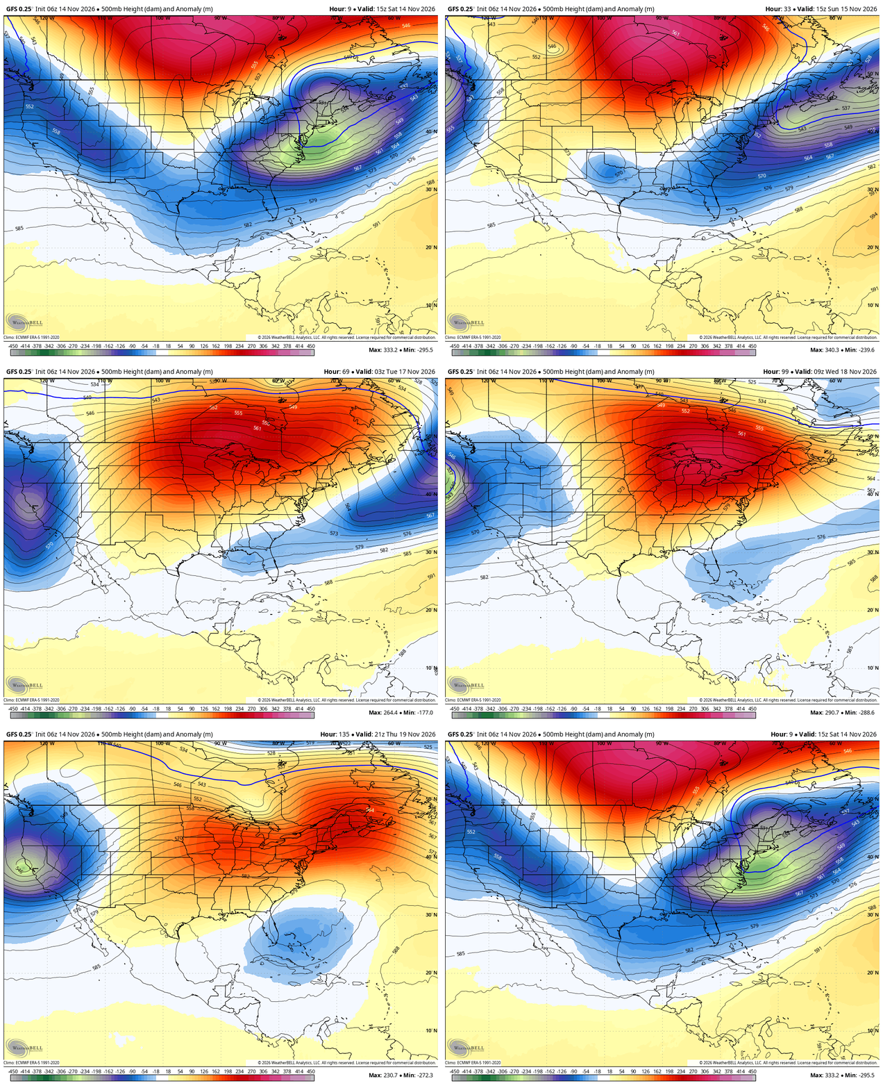
This map shows storm #1 (Saturday) rapidly exiting the Rockies, with storm #2 entering the Sierra by Sunday/Monday. A third and stronger low-pressure system is noted to arrive in the Sierra by Thursday next week (11/19).

Below: This moving map (Temperatures at 10K-C) starts with storm #2 early next week and rolls through the PNW, Sierra, and Rockies. Another cold front at the end of this loop occurs later next week with storm #3. Each storm is accompanied by these short-lasting cold fronts.

Storm #2 Sunday-Tuesday
Below: Storm #2 early next week swings into the Sierra with near double digits once again, weakening over the Rockies. Notably, this storm, with Southerly winds, aims toward Idaho (the Ketchum area could be favored), with westerly flow behind the front pushing it into the Tetons and most of Utah. Colorado is a wildcard, with some double digits possible in the southern San Juan Range. You can also see some snowfall in BC, especially the western regions. The exact track of this storm as it departs the Sierra early next week can still change.

STORM #3
Below: Storm #3 snowfall totals seem impressive for the Sierra by Thursday next week. That system takes a wide stance over much of the Rockies and likely will yield some decent totals to many resorts. While it weakens a bit like the previous storms, it seems to hold together a bit better and has colder air with better snow ratios. You can see upwards of 20 inches in the Sierra Range.

Bottom Line: Progressive pattern continues into next week. Each system should offer double digits to the Sierra and moderate to perhaps double digits in isolated areas of the Rockies. The 3rd storm due later next week might deliver heftier totals.
Forecaster: @powderchasersteve (Instagram)
If you read our free forecasts, please consider supporting us with some of our high-quality merch in our powderchaser store. The Concierge program gets you to the deepest powder with every storm!
HELP US OUT- Please support your love of powder and our free forecasts with a donation here