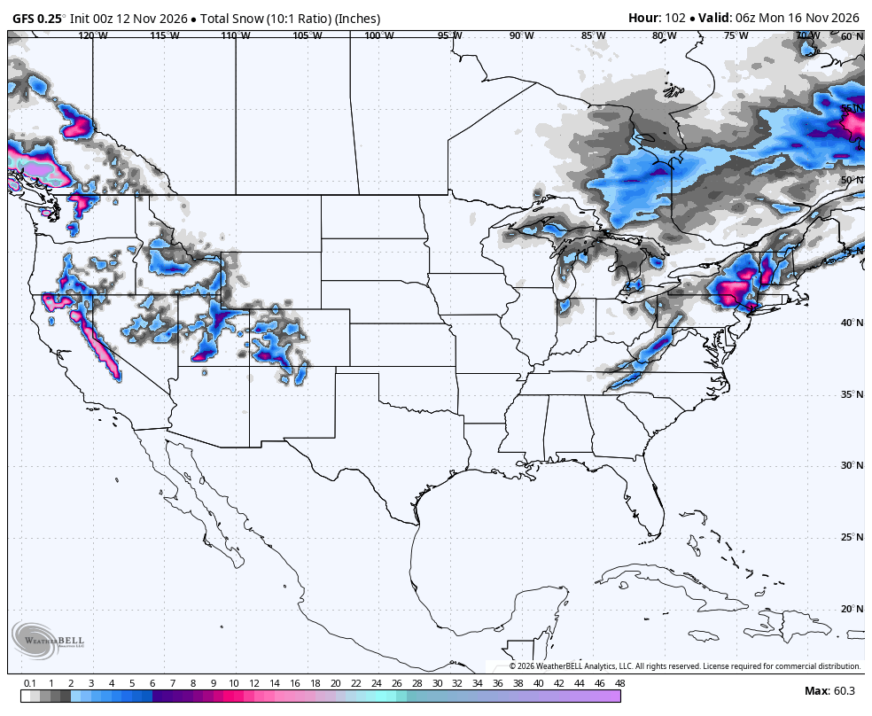
Significant snowfall is likely for the mid and upper elevations of western BC, as well as most areas in the Sierra in the next 1-3 days. Some peaks in BC might exceed 15 inches. The Sierra storm looks intact for double digits above 8K and even some 4-8 inch totals at the bases this weekend. Wrung-out moisture hits the Rockies later this weekend; however, colder air and NW flow might pull a few surprises for the Wasatch and, if you're lucky, southwest Colorado (Wildcard). New England scores some wet, dense powder by Friday.
ANNOUNCEMENT: Mountain Collective Passes go up in price starting November 16th ($729 for an adult pass now). You can purchase or renew here.
We will broadbrush the next 3 days. The Sierra is likely the highlight from early Saturday morning through midday. Amounts look plentiful above 8K (7-15), and will be lower by mid-Saturday morning with colder air (5500K-Lake Level). If this were mid-winter, the storm would be a marginal chase due to very strong mid- and upper-level ridge gusts (95MPH). Amounts from 6K to 8K likely land in the 5-9 inch range.
Whistler looks to be in the spotlight, teasing Friday/Saturday, but ramping up to 10-18 inches above 5500 for Saturday PM to Monday. Upper elevations of Whistler will be deep. Below 4500 will see mainly rain.
Chases if resorts were open? Sierra:- Right-side-up snow, great base build, especially mid and upper mountain. Wind buffing will only consolidate the base further. (Winds will be strong). Whistler: Mid- and upper-elevation powder. Utah surprises in the Cottonwoods (Moderate totals) by Sunday morning (Moderate totals).
Below: 10K wind speeds are extreme with this storm in the Sierra (Ridge gusts 95 or higher). Wind Buff!

Below: Sierra snowfall peaking from late Friday night into Saturday mid-morning. You can see widespread double digits along the Sierra Crest, impacting the southern and northern Sierra (11-15 at upper elevations).

Below: This GIF provides you with a national spotlight of POW from Friday night into Sunday morning. New England peaks Thursday night to Friday, the Sierra Friday night to Saturday, and the Rockies Saturday/Sunday. Western Canada (Whistler) gets deep from Saturday night to Monday (5K snow level). Interior BC will see lower totals.

Below: New England peaks very late Thursday night into Friday. Temps are warm with this storm, so rain will precede the snowfall, with colder air Friday (Near freezing at many base areas). Unfortunately, warming occurs behind this storm. My forecast is widespread 3-7 inches for southern Vermont and parts of inland NY State, with a bit less for the White Mountains of New Hampshire.

Rockies:
Storm moisture is decreasing as it moves into the Rockies Saturday afternoon. Southerly flow is not ideal initially in the Wasatch Saturday (7- 8 K snow levels). Much colder air (Phase 2) moves in Saturday night into Sunday with NW flow, limited moisture, and some surprises possible in the Cottonwoods (7-11). This is a similar setup to the last storm that provided deep totals; however, less moisture will likely keep the amounts lower. Other resorts in Utah likely land 3-6 inches (North to Powder Mountain) at upper elevations. The Cottonwoods might deliver!
Colorado shows the low tracking directly over the central mountains, peaking late Saturday into Sunday AM. Moisture is limited, with the best odds of higher totals (4-9) showing up near Telluride (NW flow) or perhaps the central mountains. Areas north along I-70 see lower totals (2-5). Chase central or south. The northern San Juans might win the game.
Below: Colorado totals focus on the southern mountains, primarily western areas north of Durango. Wolf Creek is more of a wildcard in my eyes.

Extended:
Low pressure keeps the cards in play next week with additional snow for the Sierra and Rockies
Below: 24-hour incremental snow totals look decent from Monday to Friday next week. You can see 2 distinct storms keeping areas in the PNW, the Sierra, and the Rockies active. WOO HOO.

Forecaster: @powderchasersteve (Instagram)
If you read our free forecasts, please consider supporting us with some of our high-quality merch in our powderchaser store. The Concierge program gets you to the deepest powder with every storm!
HELP US OUT- Please support your love of powder and our free forecasts with a donation here