
We just came off a very good storm cycle for the west, finishing up in Colorado and New Mexico with double digits. We are entering a phase of long-range high pressure (Blocking ridge in the west pushing cold air and moisture north and east of the west. Wet Pow is possible later this weekend in BC. New England fires slowly with a larger storm later next week. Alaska grabs deep but warm storms.
This post is sponsored by Downslope Mobile tune shop in New Mexico! Take advantage of their mobile tune shop that can come to you with all of this new New Mexico snow.
 Here are a few notable storm winners in Colorado and New Mexico on our last storm from Thursday to Friday (Dry density powder).
Steamboat: 15 inches
Powderhorn: 15 inches
Ski Santa Fe: 14 inches
Ski Apache: 14 inches
Taos: 11 inches
Aspen: 10 inches
Silverton: 9 inches
Beaver Creek: 8.5 inches
Forecast Discussion: The upcoming trend is for a warm storm to impact the western areas of BC and the northern Cascades of Washington from Sunday to Monday. High pressure has settled in elsewhere in the west, with a long trend for powderless days, perhaps past mid-January. There are a few clues of a backdoor cold front over the Rockies mid-month and a chance of some snow. New England grabs several periods of light or moderate snowfall with a larger storm tracking up the coast by mid-January. Alaska is active, but peak periods of snowfall seem to come with warmer temperatures. There might not be an optimal chase aside from the East Coast later next week. AK is a possibility also.
SPONSOR ALERT WITH GREAT POWDER NEAR PARK CITY- UINTA'S
Park City Powder Cats got 17 inches of blower pow earlier in the week. This Zone in the Uintas;s has very good snow totals and quality right now if you are in Utah and want to avoid the lift lines and ski untracked powder.
Below: Total snowfall from late Saturday to early Sunday in the PNW and western BC. Timing is good, PM Saturday to early Sunday. Snow will favor Whistler mid-mountain to the summit, and the mid to upper slopes of Mt Baker. The Good: Timing of PM to overnight snow. The Bad: Temperatures fluctuate with colder air initially and warming. Bottom Line: Chase now, as it's not going to snow for a while. Surf is up, so grab it.

Below: 4K foot temperatures later Saturday night ride to near or above freezing. Snow levels will trend near or above the base at Baker and just below mid-mountain at Whistler Saturday/Sunday. Interior BC is also warming.

The extended shows a trend for high pressure for the west and some storms likley for the east. The full details are below.
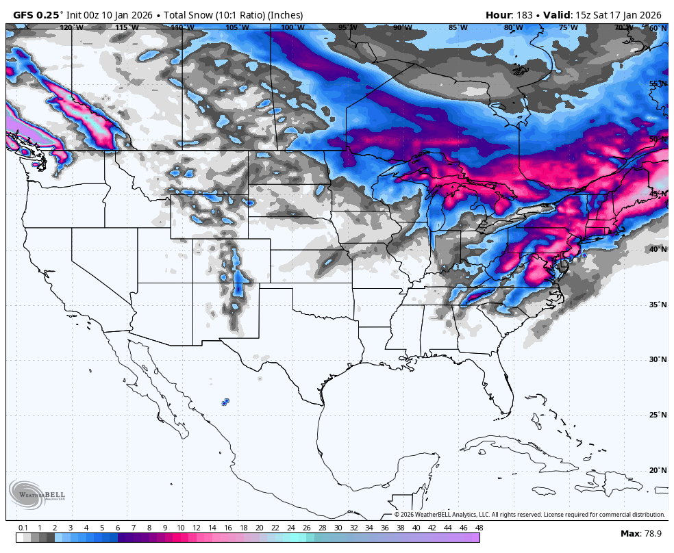
Below: 1/10 to 1/17. Low-pressure exits the Four Corners this weekend (Start of the loop) while high pressure builds into the west. This loop extends out to next weekend when a cold front and weak system might skim the Rockies (TBD) and head south towards the Baja. Meanwhile, a stronger signal of lows is evident over the Midwest and East Coast as the western ridge pushes storms north and east. A deep low is on this chart in the Mid Atlantic extending up the New England Coast later next week (End of loop).

Below: 7-day total snowfall (1/10 to 1/17). The west bumps up in BC and the north Cascades this weekend and early next week (High snow levels with warming), while the Rockies and Sierra are bone dry aside from a skiff possible at the end of this loop (Cold front).
New England slowly ramps up with some light to moderate storms and peaks with a coastal storm towards the end of this loop (1/17). Cold air from the late New England storm (later next week) might push snowfall into metro areas along the East Coast, extending well south towards DC and the Carolinas. Chases might be more plentiful in the southern and eastern areas of New England, and south to the Mid-Atlantic.

Below: 10K foot temps from today (1/10) through next weekend (1/17). The cold air currently in place over the Rockies pushes east with a warming trend. There are signals of cold air returning to the Rockies by the end of this loop (1/17). The PNW and Sierra stay warm. The East Coast and Midwest stay colder. (Date and day are in the upper right).

Below: New England Powder shown in 24-hour increments, 1/11 (light to moderate snow this weekend up north) to next weekend when 24-hour snowfall totals look deep in southern and coastal New England (Later next week).

Alaska?
Alyeska stays active with big snow totals later this week; however, temperatures are warming as peak snowfall intensity comes in later this week.
Please help us out if you read our free forecasts by considering some of our high-quality merchandise in our powderchaser store. or Concierge.
HELP US OUT- Please support your love of powder and our free forecasts with a donation here, or join our concierge program. We have merch on the website.
We appreciate the support.
Forecaster: Powderchaser Steve @powderchasersteve (Insta).


