SUMMARY POW: As forecasted, the southern mountains of Colorado, including Arizona scored multiple days of nearly double digits since Thursday. I updated this post last evening with low confidence for much snow on the I-70 corridor. I had better confidence for Aspen, CB, and Telluride, perhaps Sunlight. Things developed as planned however only 3-5 inches fell last night for the southern Mountains. The week ahead looks decent for New Years and even better in the extended forecast with 2 additional systems on tap for the West.
FORECAST POW:
Snow showers are continuing around the Metro areas of Denver/Boulder and will continue through late AM. The ski areas are just a bit too far west for any real accumulations so today may be best to skate ski or hike around the Front Range of Colorado if you were planning to ride powder this morning. However, if you are in the San Juan Range additional snow fell Friday night at Telluride (4 inches), Purgatory and Wolf Creek so conditions there will be fantastic this morning.
Aspen was on the northwest edge and will likely also be a good choice Saturday morning.
Here are a few reports this morning that Joel posted from the Colorado OpenSnow forecast (24-hour totals)
Southern Mountains
Silverton: 20”
Purgatory: 15”
Telluride: 14”
Wolf Creek: 12-16” (estimate)
Central Mountains
Crested Butte: 7”
Monarch: 5”
Powderhorn: 5”
Aspen Mountain: 4”
Aspen Highlands: 3”
In the next 48 hours, the only real pow to talk about is a new system that enters the Sierra Sunday night. That is a weak trough that is likely to land 3-7 inches favoring the northern lake and push southeast towards Mammoth. The models seem to push moisture east so my confidence on any high amounts at Mammoth is low currently. The north might be favored for resorts along the Sierra Crest.
That system will pick up additional moisture from the Pacific and provide another decent round of snow for the southern Cal resorts on Monday (Mountain Hight, Mount Baldy, Big Bear).
The extended forecast has promise for a snowy New Years and another storm late next week for many areas of the West.
EXTENDED POW:
Next week looks active for BC (Coast and interior) with several rounds of snowfall. Warm temps through mid next week will focus amounts at upper elevations of the coastal resorts (Cooler inland) and all snow for most of the interior. There are 2 storms to talk about.
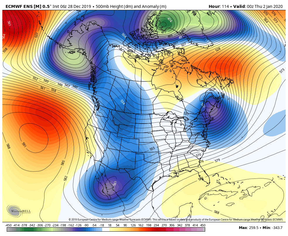
Moisture drops south through the northern Rockies in the New Year's Eve time frame favoring the northern Rockies. This will be good news for the Panhandle of Idaho (Schweitzer), Northern Montana (Montana Snowbowl), before moving into the Tetons, southern Montana (Big Sky), and Wasatch for powder on New Years Day. Colorado is favored for the northern mountains but it's too far out to predict details currently.
Below: Trough favoring the northern Rockies and BC for New Years Day

The pattern towards the end of next week brings an additional system that is colder, dropping snow levels in the Pacific Northwest and Rockies. This is likely to land decent numbers in many areas including BC once again.
Below: Long-range ensembles favoring BC with a deeper trough that will also enter the west late next week or weekend. This is likely to land higher amounts to many areas than the initial wave on New Years with colder temps and higher snow ratios.

Enjoy the Powder everyone! I am headed to Silverton For Sunday.
Powderchaser Steve


