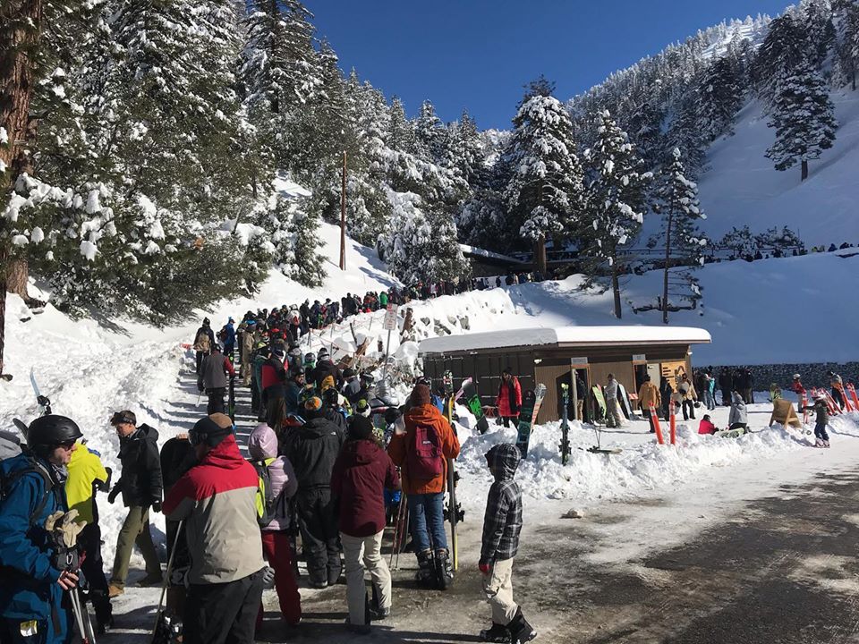
I just experienced the most unusual ski resort in my life by chasing to Mount Baldy just 45 minutes outside LA that sits surprisingly high with a 6500 feet base elevation and 8500 at the summit. This was my first chase to southern CALI. You can see the ocean from the summit. 2-3 feet fell yesterday and another 2-4 inches last night. At 6:45 AM this morning a line of 30 cars were already lined up for closure at the parking area (The plows were still plowing). Regardless of wind impacted powder, the experience is worth the trip (Fly to Ontario airport- Frontier flight was $100). The drive from the airport is only 45 minutes or less if you are lucky. Let me sum things up below and then get to the forecast.
Mount Baldy Ski Area.
1) Extreme grassroots mom and pop operation- General manager collected the $5 parking fee, but then ran around frantically rearranging the ticket window lines (50-100 people in line), then he ran to the lifts telling lifties when to open the chair and would snarl at you if you asked any questions (just like the Soup Nazi from Seinfeld).
2) Think backcountry steep terrain serviced by a 50-year-old chairlift that runs slower than a snail.
3) Ski Patrol- Old school ski cutting and very few bombs (Only a few patrollers).
4) Buy your tickets at the base, rent at mid-mountain after riding chair 1. Carry your skis and boards onto chair #1 since the ramp was not low enough to wear your equipment.
5) Bring cash! Credit card machines are not dependable. Be prepared to wait at several ticket windows as each one serves a different purpose. Our line was moved at least 3 times since I started at 7:30 AM.
6) The terrain was a plus- but most chairs open very slowly. Liftline at chair 1 trumped anything I have ever seen. If you get lucky and the snow level drops below 4000 with little or no wind (Rare), you are in for a surprise! Think a mini Taos, Alta Chutes at JHMR, Over the Rainbow at Loveland type terrain.
Below: The lift line at 10 AM Friday at Mount Baldy Ski Area. This does not show the other 50 folks extending to the end of the parking lot. The line circles at the top to chair 1 out of view on this photo. My best guess was a 2-hour wait. Per a few folks that emailed me the ticket window line plus the lift line was over a 3 hour wait. Photo: Powderchaser Steve- Powderchasers.com

On with the forecast:
The short term high-resolution models show your best odds of powder will exist near Wolf Creek with moderate snow Friday evening into Saturday. Telluride models and areas further west and north show less. Telluride got nailed today with 12 inches since 5 AM (Snow telemetry at the PHQ). Winds shift to the NW tonight that can cause snow to increase at Telluride. That said, winds today were from the SW and while Telluride is not often favored with this wind direction, precipitation outperformed significantly. Moisture was higher further west in the San Juan Range so areas like Purgatory, Telluride, and Red Mountain Pass who all did well today (Silverton likely picked up a foot).
The models are showing another 2-5 inches for the Northern San Juans (Telluride) Friday night with perhaps 4-8 for Wolf Creek further south and East. The only other spots that are worth watching are Crested Butte, and Aspen who may see some moderate snow by Saturday morning per the models (3-6 on the AM report). Don't forget that tomorrow morning's report will include the snow that fell heavily on Friday for most Mountains in the San Juan Range.
Summit County and areas west to Vail are going to reap some light benefits with the wind shifts on Saturday to the W, NW. Higher amounts are likely for the Denver Metro area foothills as winds veer North/NE over the Front Range. Eldora is a wildcard, but can also get skunked with moisture favoring the eastern areas (Worth watching the snowcam there). Loveland Pass may see a tease. Confidence is low for most areas along I-70.
Bottom Line: Snow will shift from the San Juan Range late Friday night to favoring areas west on I-70 and East towards Denver. The ski areas favored are the western sides of I-70, Sunlight, Aspen, perhaps CB, Snowmass and Beaver Creek for a wildcard. Other areas will see lighter snowfall. The Divide resorts are a wildcard (Loveland) with higher amounts in the Denver foothills or eastern Plains.
If I were on the chase, I might nab an open spot at Silverton- Guided hike terrain) for Saturday or Sunday (Open spots). Also watch for more snow at the Wolf, Telluride, Crested Butte, and Aspen. Highest confidence if for Wolf Creek.
Another system enters the west with a moderate event for the Sierra early next week. This will also land another dump for southern California by Monday. The long-range trend for beginning New Year's Eve is for a very active period for BC that may extend south into the Cascades and the northern Rockies. I have high confidence for BC.
I will be at Silverton on Sunday.
Enjoy the Powder
Powderchaser Steve
The


