SUMMARY POW
It's snowing heavily in the Pacific Northwest, especially the northern areas towards Mount Baker and into Canada at Whistler. The long term pattern for the west looks very unsettled over the next 7-14 days. The Cascades, Coastal BC, or the Panhandle of Idaho will be the best places to ride powder over the next 3-4 days. Much of the West may see snowfall in the extended regime.
FORECAST POW
I am once again posting from the Mica Lodge (Heli Ops) in Canada where another 40 CM fell yesterday. Here is a picture of me just above the lodge on Friday. Heli Ops were suspended due to icing and will most likely resume on Saturday.

As of 6 AM Saturday, here are a few reports from the NW for snowfall totals.
Mount Baker- 13 inches in 7 hours (Low snow levels).
Whistler-13 inches overnight (16 in 24- and finally broke 100 inches YTD).
Stevens Pass: 4-6 inches
Crystal: 6 inches (Chair 6 webcam)
Below: Whistler webcam Saturday morning. Much higher amounts likely feel towards the summits.

The short term forecast will bring steady light to moderate snow to the Cascades over the next 24 hours. Looking at the Radar there appears to be a convergence zone setting over Stevens Pass that might increase totals by the end of Saturday. Intensity may decrease somewhat elsewhere. The snow levels are low with high-quality powder falling on a wet surface from Friday. It's hard to judge how much you will punch to the bottom today, but if I were chasing, I would most likely head to Baker or keep on an eye on Stevens Pass with the convergence zones.
Light to moderate snow will continue into Sunday (Waves, with no single double-digit 12-hour event) with high quality (low snow levels) for much of the Cascade range favoring WA.
In the Rockies, weakened energy will benefit the Tetons over the next few days with periods of 2-3 inches or more each day. The sum total may be in the 4-8 inch range by Monday. Other spots to watch will be Whitefish in northern Montana who are likely to see some moderate snowfall Sunday into Monday.
EXTENDED POW
A warm front enters the Cascades on Sunday night or early Monday. This front will bring significant snowfall above 4,000 feet to most of the central or northern Cascades with moderate amounts further south. The snow levels may creep a bit lower with heavier bands of precipitation. Bottom Line: Monday will be a good storm ski day with denser powder at the bases and decent quality mid to upper.
These heavier snow periods will also benefit Whistler (12-15 inches) Sunday night and Monday. The Panhandle of Idaho, including Schweitzer, are likely to score a foot or more for Monday into Tuesday. You can chase from the coastal areas to the inland areas early next week.
Moisture from the NW next week appears to weaken before moving into the Rockies. While the Tetons see moderate snow in the short term through Monday, they will continue to see light or moderate bursts of energy towards the middle and end of next week (Conditions improving each day). Some snowfall will trickly north into the southern Montana ranges, as well as the northern Wasatch.
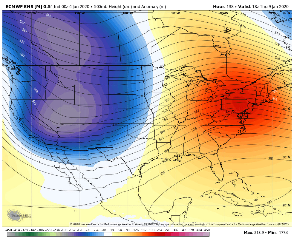
The long-range ensembles show another deep storm for the PNW late next week that has a higher chance of providing a moderate or heavy snow event for much of the Rockies and perhaps the Sierra Range towards next weekend. Oregon will also score higher amounts with this system.
Below: Another deeper trough moves into the northern Rockies and perhaps the Sierra towards the end of next week.

The longer-range ensembles show a continued trend of decent troughs entering the west in the 7-14 day period. It's likely that the west stays in a unsettled pattern with much colder temps. In fact, its likely a polar vortex with frigid temps moves into BC towards the end of next week.
If you want to score the deepest powder, join our Concierge program for custom forecasting down to details by resort and region customized for your trip.
Enjoy the powder everyone.
Powderchaser Steve


