Summary:
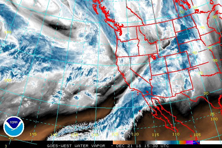
Several low-pressure systems will impact the western US over the next 3-5 days. While few will land an overnight double-digits, its likely that the Cascades, Sierra, Tetons, Western Idaho, Panhandle, southern BC, Utah, Colorado, and even New Mexico see decent snowfall spread out over the week. Xmas Day could be a moderate powder day in the Sierra from late snow XMAS Eve to XMAS.
Forecast:
My last forecast nailed the Cascades but completely went bust on the Rockies! Thankfully I chased to the Cascades where 27 inches fell at Crystal. What happened? The models through Tuesday evening all showed 5-10 inches for the Tetons and 2-5 inches for most of Colorado favoring Steamboat. Steamboat and the Tetons only nabbed 2-4 inches where areas further south towards I-70 in Colorado nabbed 9-16 inches. Breck was the winner by far (16 inches). The short-term resolution models picked up on these changes by Wednesday morning but by then it was too late (Chase was in progress). I had a local in Breck (He is always in the front of the line- Yellowjacket) tell me \Wednesday was one of the best days he has ever had on the TBAR at Breckenridge with free refills all morning\" \"it was blower powder all morning\"
Below: TBAR terrain on Thursday morning after it reopened from closing early Wednesday afternoon. - Snow was more wind impacted than Wednesday.

There will always be times that the models and even the best forecasters go completely bust! Wind directions, microclimates, orographic enhancements etc. can all play games on our forecasts. That actually plays in our favor at times with sneak up powder days, storm skiing with no lift lines etc. I always learn something from every missed forecast. I was 1 hour in drive time to the Tetons Tuesday night when my hunch turned me around with a $120 flight to Seattle. That scored me a fantastic day at Crystal for Wednesday morning before returning to Colorado that night. I caught the reopening of the TBAR Thursday. There were plenty of wind impacted areas (Gust still at 37MPH). Reports from Vail \"no wind and butter smooth powder in the back bowls\" Also, some good shots coming in from Loveland for Thursday.
Below: Crystal Mountain - Wednesday morning - Base area

Let's get on with the forecast: 4-6 inches fell last night at Brundage with light snow currently in the Tetons. That system drags over Colorado after midnight Friday into Saturday. Models once again are not getting me excited. Joel Gratz has 4-8 inches for many locations (I hope he is right). I am favoring the central mountains near Crested Butte initially (SW winds) before winds shift NW early Saturday morning. Areas west of Glenwood, perhaps Powderhorn may also do well. Expect 3-6 inches in the Gunnison Range by Saturday morning and 4-7 inches from areas of the Flat Tops north of Rifle. Steamboat is a contender for 2-5 inches where areas near Vail Pass may hit the 3-7. Areas further east towards Summit may see slightly less. Northern Utah should also see a light freshening with perhaps as much as 3-7 inches in the Cottonwoods by early Saturday.
If your chasing powder in the next 5 days it will be hard to miss out, however a bit trickier to find any 12-hour deep period. I especially like the northern Cascades (Baker) including Whistler for PM Saturday through Sunday. Snow moves south on Sunday for the central and southern Cascades (Alpental, Stevens, Crystal) and may land some decent totals in the Oregon Cascades. Try riding pow late Saturday up north and further south on Sunday (2 powder days in a row). Expect generally 5-10 inches by late Sunday in many areas. The northern Panhandle of Idaho will see some moderate amounts during the period including southern interior BC.
The Sierra reaps the XMAS eve award for snowfall into XMAS day. I favor the northern Sierra best. The models have downtrended somewhat with this storm. The Good: Mainly overnight pow. Christmas. Caveat: Amounts may only be 5-11 inches.
Below: Total snowfall through Tuesday for the west (Highest amounts in the PNW, with decent amounts for many areas of the Rockies). This map will look much different especially for Colorado mid to late next week.

EXTENDED:
Next week ushers in several consistent waves of light or moderate snowfall to the Cascades and Rockies. The Cascades could get deep from the several day events of 3-7 inches every 24 hours through late Monday. The models have disagreed somewhat on where this lands in the Rockies. My guess is that western Idaho, Tetons, most of western Montana see continuous light snowfall early next week (4-9 inches) especially late Sunday night and Monday. You may aim for the northern Panhandle for late Sunday or Monday (Moderate amounts). On Monday consider some storm skiing in the Tetons, Western Idaho, or the Wasatch (Moderate amounts unlikely to exceed 8 inches in any 24 hour period). The Cottonwoods may see slightly higher amounts.
In Colorado, there is an uptick of moisture on Monday for the northern portions near Steamboat that drags south over Aspen and the San Juans for Tuesday. Light or moderate snow will be falling in Summit County early next week. Steamboat may score the higher amounts on Monday? The GFS and EURO do not agree with the midweek pattern. Its likey that the brunt of moisture for Wednesday will be falling in the San Juans of Colorado. One model shows higher amounts near Wolf Creek extending into most of New Mexico. The Euro favors a deeper solution for Telluride, Silverton, Purgatory (Further north and west). I suspect double digits are likely midweek in some of these areas. That system per the Euro swings north over the Front Range on Thursday bringing healthy snowfall to many areas of Summit County and areas east.
Powderchaser Steve


