SUMMARY:
Isolated pockets of 5-9 inches Sunday for the central Cascades with 2 more storms on the horizon for the PNW. Further east decent snow totals are possible in Idaho, Montana, Wyoming, Utah, and eventually Colorado by midweek. Very cold temps migrate to warm by late next week. Some decent totals are possible for the Northern Rockies by midweek. The last week of December may get active again.
Powcast:
Timing is a bit slower for the PNW on Sunday morning with very little new snow noted on automated telemetry. The models still show a band of moderate snow forming, especially for the Central Cascades of Washington for storm skiing on Sunday (Hit Stevens, Alp, or Snoqualmie). Stevens may end up with 4-8 inches by late Sunday evening if the PSCZ sets up (Cold westerly flow). Watch the webcams and make quick decisions to chase for late Sunday or early Monday. Bottom Line: Not a big storm, but if the band of snow sets up over the passes (Highway 2 or 90) with cold temps things can get decent quickly. Stage and be prepared to chase Sunday or Monday.
Below: Total moisture through late Sunday evening favoring the central or northern Cascade range of Washington with roughly 1/2 of moisture noted near Stevens Pass or the I-90 corridor. This is a narrow band of snow that hopefully sets up with westerly flow (Puget Sound Convergence) and is a bit hard to predict with certainty. The best hope is 4-8 inches by late Sunday evening. Some light snow is also noted for Northern Idaho near Selkirk Powder Guides.

The PNW will be the most active for the upcoming week with another moderate storm due for Tuesday AM to PM, and a larger swath of moisture due Thursday-Friday. Originally the models showed warm air overtaking the very cold temps in place currently. Models show a trend for the colder temps to hang on through at least Thursday for the western Cascades and certainly further east. It will warm considerably for the Seattle metro area by mid to late week. Most of the snow this week for the PNW will favor Washington State with less noted in Canada until the final push mid to late week (Western Canada might score some moderate numbers versus the interior of BC late week).
Bottom Line PNW: Moderate storm isolated to the Highway 2 region or I-90 Sunday. Increasing moderate to perhaps heavy snowfall Tuesday mid-morning to Wednesday. The final push of moderate or heavy snow is possible for Thursday/Friday. Warming towards the end of the week with some hope that cold air stays trapped over the mountains (Seattle will warm into the upper 40s or 50 by late week after sea level snow early to midweek). Central and northern Cascades will outperform the southern areas, however, by mid to late week snow will also be falling as far south as the Northern Oregon Cascades albeit in lighter amounts.
Rockies:
The chases from the PNW look to favor the central panhandle of Idaho extending south into the Tetons and perhaps the Wasatch by Wednesday. Steady light snow is likely for the Tetons from Tuesday to Thursday peaking early Wednesday morning with 2-3 day totals in the 7-14 inch range. The models have come into better agreement showing some moderate amounts for the Wasatch range especially Wednesday/Thursday (5-11 as an early guess). There might not be a single 12-hour double-digit event but sum totals could be decent. Higher amounts are likely further north in Wyoming.
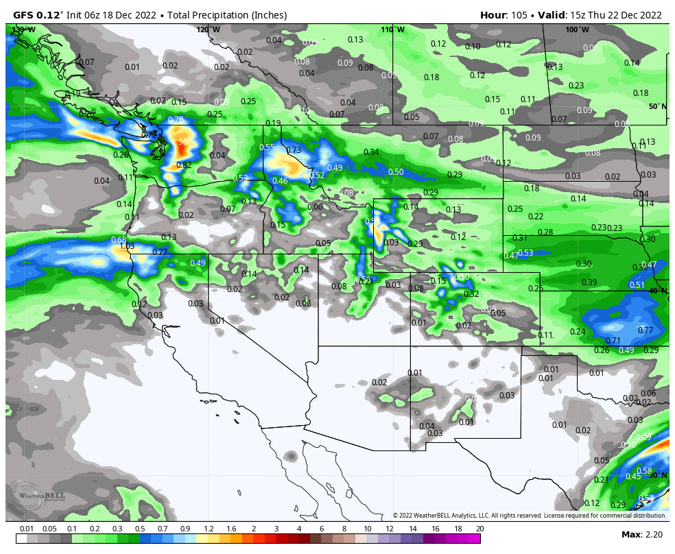
Below: By late Wednesday precipitation amounts have increased (Totals from Sunday to Wednesday 12-22) with 1.5-2 inches of moisture noted for much of the central regions of the Cascades. The central panhandle of Idaho and even areas near Missoula (MT Snowbowl) or east (Discovery) could also score some decent amounts. You can see some decent amounts noted in the Tetons as well that mainly fall from Tuesday to Wednesday PM.

Below: You can see a strong cold front slamming into southern Montana and Wyoming on Wednesday morning and reaching Utah late in the day. This might enhance snow ratios and totals along and behind the cold front. Temps are at 10K feet in Celsius and are notably much colder in the northern tier. These are some of the coldest temps we have seen this winter.

Below: A warm front moves in by Thursday midday for Utah and reaches Wyoming by evening into Friday. This will decrease snow quality with such a sharp rise in temps by late next week (Look for increasing avalanche concerns). We are going from extreme cold to warm in a short period of time.

Snow develops over Colorado beginning on Wednesday morning and continues into Thursday morning. Currently, the best ride times are likely late Wednesday or early Thursday. This storm seems to favor a wide area of the northern and central mountains with moderate amounts. We are a bit far out for pinpointing exact amounts but expect some pow for your midweek period. Further south, less snow is noted. A wide range of areas grabs pow, I-70 or north might be winners.
Below: Total precipitation for the west from Sunday, December 18 through Thursday morning December 22. The highest amounts are in the northern PNW, Northern Idaho, eastern Montana, western Wyoming, Wasatch, and northern Colorado. Unfortunately, the Sierra and southern areas of the west are going to be skimmed.

EXTENDED POW
For XMAS with low confidence, it's possible some snow falls for the interior of BC. New England might score powder for December 23 into XMAS Eve morning.
The long-term models are starting to show an increased chance of low pressure for the west in the final week of December. Being that far out I don't have much confidence, however, currently, things look promising for the final days of December.
Announcement: We are looking for a few more sponsors if you want to be highlighted in our forecasts, and the millions of folks we reach each season. Please reach out to us at powderchasers1@gmail.com. We have corrected the signup issues on powder alerts so if you had an issue in the past few weeks please re-sign up with us.
If you want to score the run of YOUR life, sign up for the concierge and we will help you get there. Powderchasers and our forecast staff are supported by our readership, so if you have not donated, please do so here or join our powder concierge program where we provide 1:1 trip planning for chasing, last-minute custom forecasts, and the best pow day of your life. Support our sponsors and be sure to follow our Instagram and Facebook page @powderchasers.
Enjoy the powder everyone! I have no idea where we are headed next week. Join our Concierge if you want custom chases and to end up at the deepest resort.
Powderchaser Steve - You can follow my winter chases on Instagram @powderchasersteve


