
The Sierra just scored epic amounts of snow, which will bring fantastic powder conditions to nearly every resort from north to south. Chasing powder will be tricky depending on how long avalanche mitigation takes, as most areas are just getting started. Zero to Hero is an understatement
Moisture from the Sierra is moving into the Rockies, while unsettled conditions are continuing in the PNW.


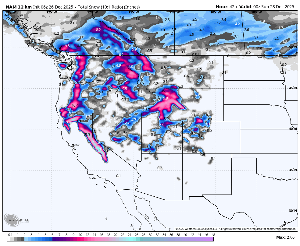
 Below: Snowfall from 4 AM Friday to 5 PM Saturday. The highlights include storm skiing in early morning hours of Friday in the Sierra (Decreasing by mid-morning), Pacific Northwest (Friday -Saturday), Central Idaho, Panhandle, Northern Idaho and Montana, Tetons, Wasatch, and a few spots possible in Colorado. Many locations on this map score 6-12 inches through Saturday morning, with higher totals in the Sierra ending midday Friday. Follow the date and day in the upper right.

Sierra Update
Aim for new openings in the Sierra, new terrain expansions, and perhaps we can get the summit at Mammoth soon. All ski areas in the Sierra received high snow totals, with resorts likely popping ropes, especially this weekend as weather improves, including mitigation. You can't go wrong with nearly every resort in the Sierra in the short term as resorts open and pop ropes.
Here are some epic 5-day totals in the Sierra as of Thursday morning (Zero to Hero)
* Mt Rose: 81 inches
* Mammoth: 78 inches
* Northstar 80 inches
* Kirkwood- 84 inches
* Palisades: 68 inches
* SugarBowl: 72 inches
PNW, Idaho, Rockies.
The northern Cascades have scored another 10 inches at Mt Baker on Friday morning, with roads still closed at Stevens Pass (TBD). Much lower totals are on the telemetry south of Bellingham. Drive north towards the northern Cascades.
The Cascades are a safe bet for additional cold powder on Friday/Saturday (Northern regions favored early Friday) in Washington (Baker) and Oregon (Timberline, Mt Hood, including some moderate amounts (7-10) for Schweitzer. The Panhandle and central Idaho also benefit in the next 24 hours. Much colder temperatures in the PNW keep quality high (7-11 additional Friday/Saturday AM). Convergenze zones set up over Stevens Pass (Closed) and I-90 Friday night, bringing decent totals for Saturday morning (-6-12). Timberline and Mt Hood will also score double digits.
The Tetons have been firing up high with good reports coming out of Jackson Hole from mid to upper elevations in the past 2 days (Dense snow has been stacking up high). The models continue to push decent totals for this region on Friday/Friday night (3-6 Friday, 3-6 Friday night), where another 12 inches is likely (JHMR slightly favored Friday initially with SW, W flow). Colder air will finally bring a decent push of snow to the bases and Jackson Valley. Storm ski on Friday and repeat for Saturday morning with high-quality colder temperatures.
Utah has good hopes on Friday for a decent push of snowfall in the northern Wasatch (Snowbasin, Powder, Beaver, Cherry Peak) that eventually trickles south towards I-80 mid-morning. The models for Utah have wide ranges of moisture from roughly .70 inches to as much as 1.5 inches. Northern Regions of Utah, towards Logan and even south to Snowbasin, likely grab the highest totals Friday with the Park City range, or Cottonwoods doing better Friday PM to Saturday (6-11) and again Saturday afternoon to Sunday with a bonus push (NW flow). There are widespread differences in the models.
Overall totals for most mountain ranges of Utah are in the 6-12 inch range. The cold front arrives Friday evening, enhancing snow quality and decreasing winds. A colder push of air with NW flow is slated for Utah Saturday afternoon into Sunday, which could bring a bonus to the Cottonwoods or even Park City (Canyons side).
While the Cottonwoods still have high confidence in 11 inches by Saturday morning, we would not be surprised to see 11-18 inch 2-day storm totals by Sunday morning (2nd push of cold air Saturday PM to Sunday). You might catch 2 mornings of powder.
Colorado is on the warmer side of the coldest air. SW flow will favor the central mountains with very high snow levels. Dense light to moderate snow is likely in the westernmost areas of I-70, favoring spots from Aspen, Irwin Lodge, Crested Butte, and perhaps Wolf Creek (Wildcard). Overall totals look to be in the 4-8 inch range. Colder air is noted near Steamboat by later Friday night with higher totals possible mid to upper mountain (7-11). That cold front moves south during the day Saturday. Enhanced snow showers Saturday night with NW flow in Colorado could bring some upside for Sunday morning near Vail Pass (Wildcard upside for early Sunday).
Below: Total snowfall for Colorado through Sunday favors the western corridors and possibly Wolf Creek Pass. Steamboat can score decent totals with SW flow pushing moisture north. There are widespread differences in the models (Some show less for Wolf Creek and higher totals for Vail Pass and a few spots in Summit County by Sunday morning with NW flow and colder air). Widespread 4-8 is on our forecast with upsides of 5-12 with areas favored in NW flow by Sunday (2nd push towards I-70). Taos is a wildcard with one model showing decent totals (Not shown). The trend is warm (Dense) to cold from Saturday morning to Sunday as Colorado stays in the warmer sector initially so totals might be low initially Friday night.

Below: Total additional snow slated for the west as of late Saturday evening. The Sierra has already received most of these totals, with areas of the PNW and Rockies getting into the action from Midday Friday to Sunday.

Bonus for Sunday morning?
Below: 24-hour snowfall ending Sunday afternoon, highlighting a second push of powder for the Wasatch (Cottonwoods favored with NW flow), and areas along I-70 in Colorado (Vail Pass). While this map does not look exciting, cold air will enhance these numbers with higher snow ratios (18:1-20:1), so even 2-4 inches on this map (10:1) can score another bonus of 5-10 inches in areas favored by NW flow (Cottonwoods, Parleys Summit, northern mountains of Colorado). Besides the powder on Saturday morning in many areas, you have a 2nd chance for Sunday in Utah and perhaps the I-70 corridor in Colorado (Wildcard bonus).

Extended Pow
The pattern is much quieter next week, with warmer-than-average temperatures likely once this ongoing cold front passes this weekend. Snow might be confined to areas of Canada. There is a good signal of snow to return near January 2-3.
Below: Total 24 hours now increments from December 29 (Monday) to January 2nd. The only notable winners appear to be in Canada, pushing south towards Whistler at the end of this loop (January 1-2). Otherwise, the deep action stays in northern coastal BC.

Below: Models are hinting at a return to unsettled conditions as we enter January with these peak 24-hour totals in the PNW, Sierra (Wildcard), and perhaps the northern and central Rockies from January 2-4. It is too far out to forecast with accuracy. This map is 24-hour incremental snowfall from January 1-January 4th (Date and time in the upper right). The period just after New Year's looks decent with colder air and increased snowfall likley favoring the north or central regions of the west (Sierra might also fire).

Below: 10K foot temps from December 29 to January 4. Warm conditions near or above freezing, even at 10K, continue in the Rockies with a cold front dropping south January 2-4 Timeframe (PNW into the northern Rockies). This cold front should enhance our odds of snowfall. Follow the lighter greens (cold air) with the date in the upper right.

Please help us out if you read our free forecasts by considering some of our high-quality merchandise in our powderchaser store.
HELP US OUT- Please support your love of powder and our free forecasts with a donation here, or join our concierge program. We have merch on the website.
We appreciate the support.
Forecaster: Powderchaser Steve @powderchasersteve (Insta).


