
Summary:
_______________________
The West will continue to see snowfall this week as a strong atmospheric river aims at California, soaking the state with up to 6-10" of liquid, with the Sierra potentially scoring up to 5 feet of snow. However, the storm will be warm for all ski areas, and rain is expected at base areas. The system arrives Tuesday night and will start with heavy rain below 8,500ft, with only the ski area summits in Tahoe seeing snow. Tahoe won't see snow at mid- or lower-elevations until Wednesday evening. Mammoth will be favored as it has a base elevation over 8,000ft, and most of Mammoth should remain above the rain/snow line. The PNW will get scraps from the AR and could receive a foot by Sunday morning. The Northern Rockies are set to stay active, with portions of Idaho, Montana, and Wyoming expected to see up to 18 inches by Saturday morning. However, it's looking like rain up to 8,000ft for most of the event, which has unfortunately been a common theme this month. Canada, however, remains highly active and continues to score great powder skiing. Looking ahead, scroll to the Extended section for an early look at next week.
Expected Snow Totals Through Saturday morning:
____________________________________________
California:
Mammoth: 4-5 feet
Palisades Tahoe: 3-5 feet
Northstar: 30-40"
Heavenly: 20-30"
Mt. Rose: 30-40"
Kirkwood: 4-5 feet
PNW:
Mt. Baker Ski Area: 10-20"
Timberline: 6-12"
Crystal: 10-15"
Stevens Pass: 8-14"
Snoqualmie: 6-12"
Utah:
Solitude/Brighton: 8-12"
Alta/Bird: 8-14"
PC/DV: 4-8"
Snowbasin: 6-12"
Brianhead: 6-12"
Northern Rockies:
Tetons: 12-18"
Bridger: 4-8"
Big sky: 3-6"
SunValley: 4-8"
Canada:
Whistler: 10-20"
Fernie: 6-12"
Revy: 8-14"
Kicking Horse: 8-14"
Sunshine/Bnaff: 8-12"
Colorado:
Vail: 2-4"
Breck: Trace-2"
A-Basin: 1-3"
Winter Park: 3-5"
Steamboat: 4-8"
Aspen: 2-4"
Telluride: 1-3"
Below: California is set to receive 6-10" of liquid (shown in brown) with up to 5 feet of total snow for the Sierra Nevada.
 Tahoe:
___________________
Heavy rain will start on Tuesday, with Snow levels beginning at 8000 feet Tuesday night, then lowering to below 6500 feet Wednesday evening. This means only the ski area summits in Tahoe will receive snow until Wednesday evening. Heavy rain below 7000 feet on Tuesday night and Wednesday could lead to flooding. Storm totals will be between 1-2 feet for Lake level towns, with 3 to 5 feet above 7,000 feet. This means most of the upper mountain at Palisades Tahoe will get good base-building snow. Winds will be a factor, gusting as high as 100 mph along summit ridges and up to 50 mph in the lower elevations and at the lake level.
Mammoth:
___________________
Unfortunately, snow levels will start high around 9,000ft, which means parts of the lower mountain and the main lodge will receive rain through Wednesday evening. Snow levels will drop on Wednesday evening below the main lodge, turning to all snow for Christmas morning. This storm will be good for Mammoth, as most of the mountain will stay rain-free due to its elevation. Mammoth can expect storm totals of 4 to 5 feet above 8,000 feet and 1 to 3 feet below 8,000 feet. Winds will be similar to Tahoe, gusting as high as 100 mph along the summit ridge and up to 60 mph at the base area.
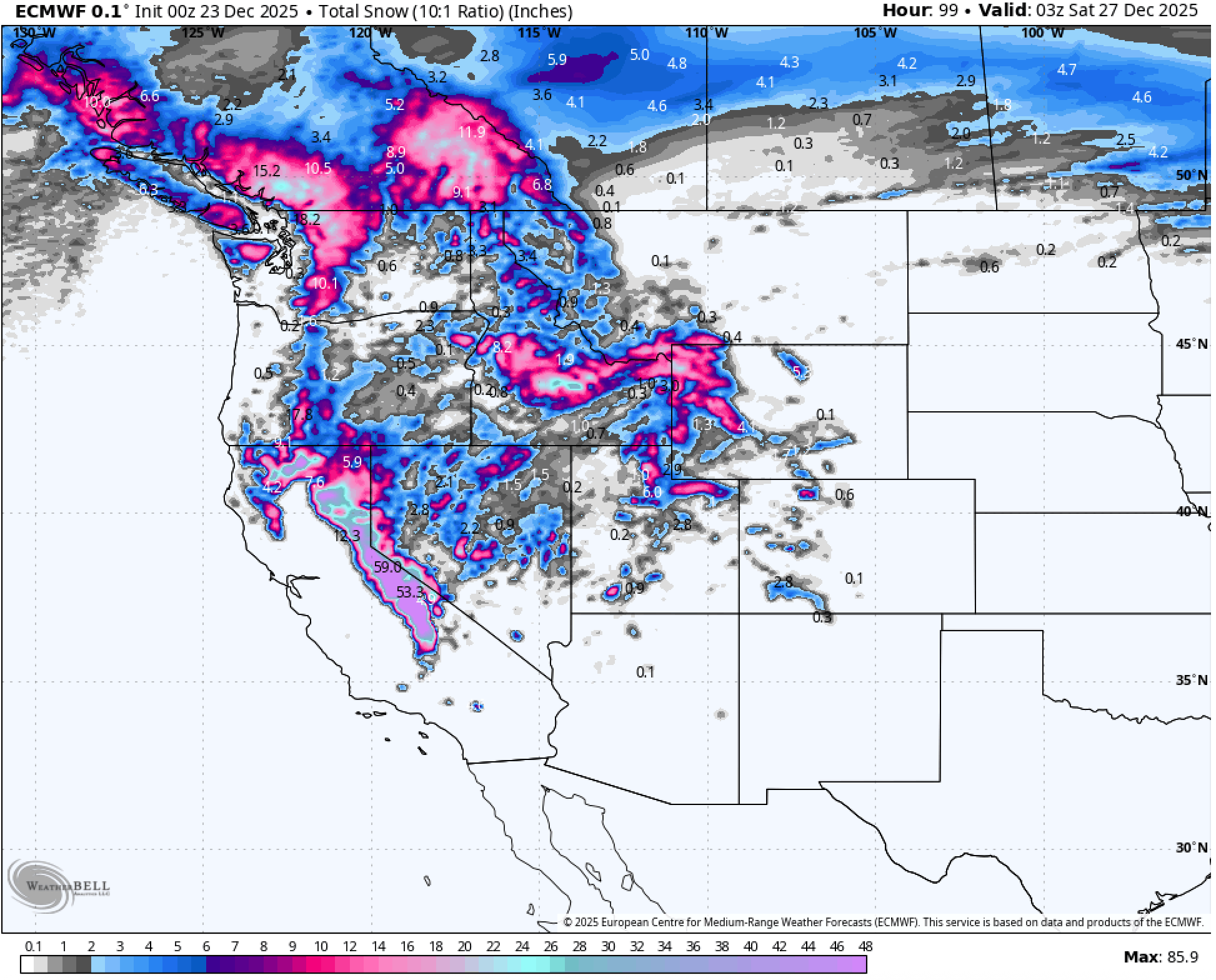
Below: Snow Totals through Friday Night. The Sierra scores the bullseye, with the rest of the West picking up totals in the 4-12" range. Heavy snow begins late Tuesday night in the upper elevations of the Sierra, and the Northern Rockies and Utah see the storm start early Thursday morning.
 PNW: (Washington / Oregon)
____________________________
Snow levels will start below base areas on Tuesday and into Tuesday night before rising to 6,000 feet on Wednesday morning. Snow levels will then drop back down to base areas by Thursday mid-morning. Most ski areas are in the 6-12" range, with Mt. Baker Ski Area favored with potential for over a foot by Sunday morning.
Northern Rockies: (Montana / Wyoming /Idaho)
_________________________________________
Snow levels will start around 9,000ft, which means up to mid-mountain elevations will see rain until Thursday midday. However, snow levels should drop to the valley floors by Friday morning, finally ending the extended warm period. Above 8,500 for the select regions in Idaho and Wyoming could see up to 18".
Below: Temperatures at 10,000 feet across the West hover around freezing through midday Wednesday, keeping snow levels in the 8,000-9,000ft range and bringing rain to most base areas. Snow levels drop on Wednesday evening.
 Utah:
Utah:
______________
Utah finally enters the mix again, with potential for up to a foot in Little and Big Cottonwood Canyons by early Saturday morning. Snow levels will be high to start, around 9,500ft, bringing rain to base and mid-mountain areas, even at Alta. Snow levels will drop hard on Friday morning, bringing heavy snow throughout the afternoon. Expect 6-12" in the canyons.
Below: University of Utah plume at Alta, UT, predicting a foot by early Saturday Morning.

Extended:
___________________
Looking dry for both the Western U.S. and Canada through January 2nd.
Please help us out if you read our free forecasts, by considering some of our high-quality merch for Xmas in our powderchaser store.
HELP US OUT- Please support your love of powder and our free forecasts with a donation here, or join our concierge program. We have merch on the website.
We appreciate the support.

Forecaster: Mark Mazzatta @mmmazzatta


