Significant September snow accumulations will blanket parts of the Western US and Canada starting today. Two storms will bring well below normal temps and much needed moisture to the drought stricken west. From the early morning snow will begin to accumulate in Alberta and BC. After a short break, the second storm will move in on Friday, dipping further south bringing the coldest temperatures of the season along with it. This moisture rich system will be fed by an impressive atmospheric river, bringing heavy precipitation to the northwest.
Storm #1
The first chance for snow is going on right now in Alberta and British Columbia. This will be a light to moderate event, bringing snow to the higher elevations of interior BC and western Alberta. While this will be confined mostly to higher elevations, there could be a few inches of accumulations at the Banff area resorts and at Jasper, possibly down to the bases. Here's one model's projection for the total snow from the first event:

(image courtesy of Weatherbell)
Storm #2
As mentioned, this storm will dip further south and bring some impressive cold air for September beginning on Friday. In addition to substantial rain supplied by the atmospheric river, the snow will creep well into the intermountain west. Before we get to snow accumulations, take a look at the atmospheric river bearing down on the Washington coastline, and then down into Oregon and possibly California.

(image courtesy of Weatherbell)
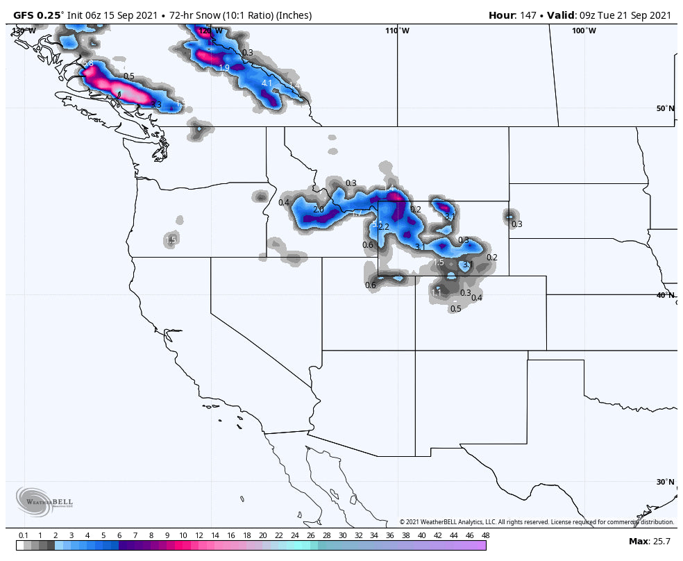
The greatest chance for significant snow accumulations for this round will be coastal BC, southwestern Montana, northwestern Wyoming, and central Idaho. However, if the storm tracks far enough south, accumulating snow will be possible in Utah and Colorado as well. The mountains of coastal British Columbia could really see some solid snowfall, where the highest elevations could see 1 - 2 feet! As far as snow in the states, up to one foot is possible in SW Montana, with 2 - 8 inches elsewhere. Here is the american model's latest snowfall prediction:

(image courtesy of Weatherbell)
This will be a slow moving storm bringing snowfall chances through Tuesday. Just to get an idea of temperatures, below is the progression of the freezing line at an elevation of 10k starting this weekend:

(image courtesy of Tropical Tidbits)
You can see those freezing temperatures traverse the intermountain west, and with it a much needed cool down will occur.
Finally, this storm has the potential to bring respectable precipitation to northern California. This would obviously be a huge help for wildfire management and for the drought situation in general. We have less confidence in the California precipitation, as the models are less consistent on just how far south this storm gets. Here is the american model's latest guess for northern California rain:

(image courtesy of Weatherbell)
Well, that'll do it for this post. We'll definitely see some snow, possibly deep in spots. We'll definitely cool off across most of the West, which will be nice. And maybe, if we're lucky, California will get a helping hand from mother nature with regards to the wildfires.
We'll be doing everything we can to get out and check out some of the snow, and we hope you do too. Send us some pictures if you do.
Luke


