
High-Level Summary:
We are issuing a Powder Alert for significant snow this week for the PNW, with several red flags when chasing. Rain and warmer air have been falling in the past 24 hours at many ski areas in the PNW and Canada (Below 5500 feet).
Cold air transitions rain to snow on Sunday/Monday. A deep surge of heavy moisture hits the PNW and Canada by midweek. That surge will bring several feet of snow to the western Cascade range, northern Oregon, and to a slightly lesser extent, western BC. Interior BC will grab a decent dose of 6-12 inches by midweek. Snow is in our forecast nearly every day in the upcoming week.
The Good: Lots of needed moisture for the PNW, and likley 3-5 feet of snow. This storm will likley be a game changer for many resorts that are struggling in the Central and southern Cascades. Northern Oregon also scores with less noted to the south.
The Bad: Brief warm-up in the middle of the week puts an upside-down layer to possibly spoil the fluff factor (Followed by colder air). Strong winds will also spoil the fluff factor on exposed ridges. Lowland snow will create issues on roads leading to ski areas. While this storm will be deep, it might not be the "perfect chase." The timing of the colder pow and less wind will be critical. The warm-up noted on the model's midweek is brief.
Jackson Airport Announcement: If you are flying in or out of Jackson, Wyoming, (Spring Breakers), there is bus service from START Transit that will keep things green and save you money. This service runs all day with a link here. The airport has limited parking and encourages folks to use the direct bus from town. Very easy and green cheap solution.
Some expected storm totals this week (M-F)
Whistler: 20-28 inches
Baker: 30-40 inches
Stevens Pass: 40-65 inches
Snoqualmie Pass: 35-55 inches
Crystal: 24-40 inches
Timberline: 20-25 inches
Mission Ridge: 9-15 inches
Revelstoke: 12-20 inches
Fernie: 12-16 inches
Kicking Horse: 9-14 inches
Whitefish: 10-14 inches (Upper elevations)
Schweitzer: 7-12 inches (Upper elevations).
Below: Cold air on Sunday will transition rain to snow in the Cascades. This airmass is very cold (-7C at 4800 feet) and will bring light density snow primarily to the central and northern Cascades (I-90 north to Baker). The rapid cool down likley results in a frozen crust layer below the fluff.

Overall pattern for the next 7 days
Below: Low-pressure systems for the next 7 days initially hover in the PNW, northern Rockies, and Canada with a blocking ridge in the Sierra and central/southern Rockies. This map is from Sunday (3/8) to Sunday (3/15). By the end of this loop, you can see the jet stream dip further south (next weekend) and might bring snow back to southern Montana and the Tetons.

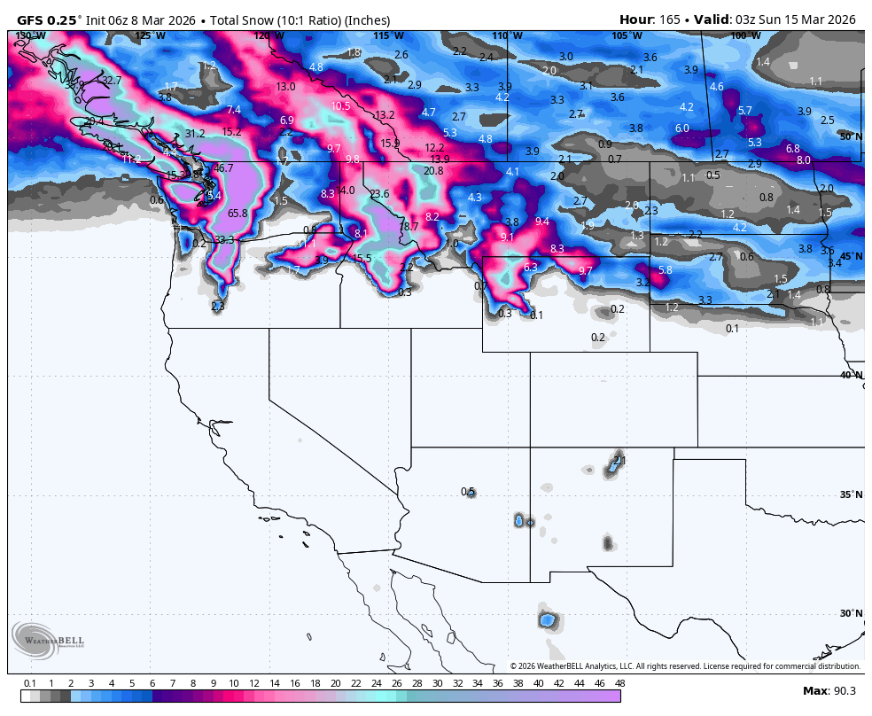
Below: Impressive snow totals in the PNW and Canada next week (Peaks on Wednesday to Thursday). With colder air, these amounts might need to be escalated.

CAT SKI ALERT: With decent snow totals for the Uinta Range in Utah in the past 3 days, we think that PC Cats (Rides high elevations in the Uinta Range, 35 minutes from Park City) might have decent bottomless spring-like powder. This terrain is outstanding. Limited spots are available here

Below: Powder map from Sunday (3/8) to Thursday (3/12). Snow fills into the northern Cascades and the southern interior of BC, short-term (Cold front). The period from Wednesday to Thursday peaks these numbers up several feet (Date and day in upper right of map).
 Below: A warm front pushes into the PNW and southern BC on Wednesday afternoon. This front is quickly replaced by a cold front by Thursday.
Of note is that the warmer air that brings snow levels to near 4K or slightly above in the Cascades at some point on Wednesday is short-lived, and might keep most of the central interior areas of British Columbia on the colder sector. Whistler is impacted for a brief period only. This denser period of snow might actually create a nice base for the fluff to follow.

Below: Spoiler Alert: Upper-level winds (10K) are very strong Wednesday to Thursday and will likley result in significant avalanche concerns, lift holds/closures, and road impacts. When we see sustained winds of 65 plus (Whites) even at 10K, it usually presents concerns. While BC will be impacted initially near Whistler, the impacts will likely be less (Interior central BC will see less wind).

HELP US OUT- Please support your love of powder and our free forecasts with a donation here, or join our concierge program. We have merch on the website. The Concierge provides 1:1 chases for the best powder (Custom forecasts) for those who want to chase the deep.
Forecaster: Powderchaser Steve @powderchasersteve (Insta)
We appreciate the support for these free forecasts.


