Hey, I am actually posting from the gate in Hanoi Vietnam as I await my flight to Laos where it is humid and in the upper 70's. I'm on vacation for another 10 days. I will be Trekking in a very remote area of northern Laos where tribal villagers remain set on traditional customs (Tribal colors, no running water, no plumbing).
The last post mentioned teasing weak storms for the Rockies. Things today look a bit meager in the short term *(Light snow for Montana, Wyoming, and Colorado this weekend). The Pacific Northwest will be somewhat active this weekend with snow levels around 5K and light or moderate snowfall at most summits north of Stevens Pass (Mount Baker summit or Whistler perhaps). The bulk of the moisture will land in the North Cascades (2-6). Warmer temps for the PNW take hold early next week before another system brings rain and snow to many areas of the Cascades and the interior of Canada by midweek. Interior BC could score some moderate amounts as early as this weekend favoring the northern resorts (Revy and north) with much less in Alberta. Another storm heads into Canada by mid next week.
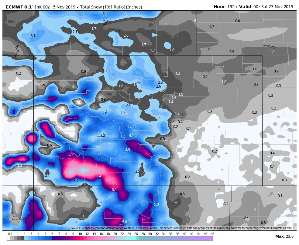
By the middle of next week, the models bring an increased chance of snowfall for most of British Columbia (could be significant) as well as an uptick of moisture and cooler temps for the Cascades of Washington. That system will eventually drop south and favor the 4-Corners at some point Thursday or Friday next week. Decent snowfall is a wildcard at this point for the San Juan Range of Colorado, AZ, NM, and southern Utah. The GFS models early this morning increased amounts while the EURO that is often the more pessimistic and reliable is also onboard. We could be looking at a good event for most of southern and central Colorado, Utah, northern Arizona, and New Mexico.
Below:The GFS ensembles are optimistic for a storm system to move into the west mid to late next week. This will likely track over the 4 corners!

Below: GFS (The optimist really likes the midweek storm that might hit the 4 corners Wednesday or Thursday). This will likely hit late Wednesday or early Thursday.

Also of note, is that it is possible that New England also sees another deep event at some point late next week or weekend.
Map below: Low pressure trough moves out of the Rockies mid to late next week and takes aim at New England.

In the long term outlook, the ensembles are still showing an active week towards Thanksgiving. It's likely that some systems move ashore from the west, but we can't speculate on how much or exactly snow will be falling. .
Announcement
We are excited to partner with @DrinkULLR to give away ten individual ULLR Nordic Libation prize packs throughout the season! Submit an original photo of ULLR Nordic Libation in the snow using the hashtag #ULLRPowderchase and Like @DrinkULLR for a chance to win some ULLR swag*. Visithttp://bit.ly/ULLRPowderChase for the official rules and more information. *Prize Pack includes an ULLR Sweatshirt, ULLR Pom Beanie, ULLR bumper Sticker, ULLR Richardson Hat and ULLR Flask. Contest begins 11/4 and ends 3/31/2020.
Powderchaser Steve-


