
SUMMARY
Significant moisture is aimed at the Pacific Northwest in the next 7 days. Lower snow levels this weekend may bring some decent chases in the short term. Rising snow levels next week will have you dodging the bullets down low and reaping cream cheese up top. The Sierra is viable for Monday morning! These systems, unfortunately, are losing moisture and \fizzling\" as they reach the Rockies.
Here are a few snow totals this morning that deserve mentioning.
Whistler BC- 35 inches in 48 hours- 67 inches in 4 days!
Mount Baker Ski Area- 27 inches in 48 hours
Bachelor and Timberline- 12-14 inches in 3 days
Crystal Mountain: 18 inches in 48 hours.
Temps have been cold enough for snow at most of the bases thus far, with reports of fairly dense snow at most areas in the past storm cycle. Very high avalanche danger kept most of the upper mountain of Whistler closed on Thursday. Mt. Baker went from a 13-inch base to 85 inches in 5 days (upper elevations). This may top the base depth of any resort in North America currently (At least Baker thinks so). Crystal has announced a tentative opening of Chair 6 on Saturday (Access to Powder Bowl only) and finally has natural snow at the base. The issues have been \"tons of snow\" in a short period of time, and a brief warm-up on Thursday creating operational and patrol nightmares (Rising Avy concerns understandably).
The next 24-48 hours brings a return of snowfall for the Cascades and BC. Light to moderate snow is likely at Whistler Friday/Saturday (5-10 inches) with reasonable snow levels (Snow level should stay just below mid-mountain). The Cascades of WA and Oregon will see lower amounts primarily Friday night (3-7). You can storm ski up at Whistler Friday and chase some pow down to Washington or Oregon on Saturday (Lighter amounts). Baker may end up winning the numbers game?
Saturday will feature a break from most precipitation at most ski resorts in the PNW. This may allow areas to dig out and open new terrain.
In looking for chase spots elsewhere, I am inclined to believe the northern Sierra would be a good place to position for Monday morning. Moisture from the PNW moves south over primary northern California. A fast-moving storm with 5500-foot snow levels will bring snow to the Sierra Sunday PM to Monday AM. Expect 6-11 inches for your Monday wake up call. This will favor resorts on the northern side of the lake, with less snow falling in the southern regions (Sugar Bowl, Alpine Meadows, Homewood, and Squaw may be favored).
Below: Northern CA favored for a good shot of snowfall into Monday morning. Lighter amounts in the southern Sierra.

EXTENDED FORECAST
Moisture increases significantly next week in the Northwest. Snow levels also rise especially Sunday and again Tuesday/Wednesday. Monday may offer decent powder to parts of the Cascades (4,000-foot snow levels). Warmer temps on Sunday may squash hopes of a smooth surface. As it cools Monday moisture will wean by late morning. BC may benefit from slightly cooler temps Sunday-Wednesday. Significant high elevation snow will continue for Whistler (Rain at the bases and even mid-mountain at times) through Midweek. Interior BC may offer decent snow at upper elevations especially mid next week when snowfall increases.
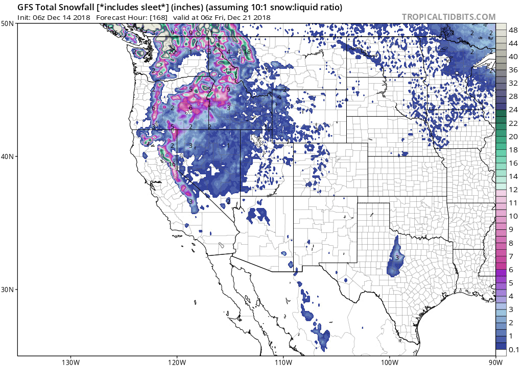
Below: Significant moisture for the western PNW in the next 7 days (10 inches or more). Unfortunately, high snow levels will limit the amount of snow at lower elevations. Perhaps the interior offers a better solution with slightly cooler temps? Someone is going to report 50-70 inches of snow at a summit location by next Friday!

Below: Mid- next week ensembles continuing to pump moisture into the PNW and interior BC

The summits of the Panhandle of Idaho may also reap some decent rewards early next week (High snow levels).
While no single period really excites me to chase due to warming temperatures, I somehow think northern resorts especially Canada may reap some good days.
The long-term ensembles show a possible return to some storminess for the Rockies for Xmas or shortly thereafter. It's too far out for accuracy but at least a glimmer of hope for Santa's dreams.
Below: Snow may return at some point to the Rockies as we approach XMAS

POWDERCHASER STEVE


