Currently it is snowing lightly in the Denver Metro area (Freezing rain-snow) with 1-2 inches in some of the higher elevations. The Ski areas in Colorado as forecasted yesterday only grabbed a trace to perhaps an isolated 1 inch. We highlighted Montana for light snows for Bridger and Big Sky who came in as expected (Bridger snow telemetry is at 3-4 inches, while Big Sky is at 1-3 inches). Temps in Denver dropped from nearly 70 degrees yesterday (I was mountain biking) to 17 this morning!
Below: Webcam this morning from Bridger Bowl Ski area in Montana (3-4 inches on automated snow telemetry- unofficial)

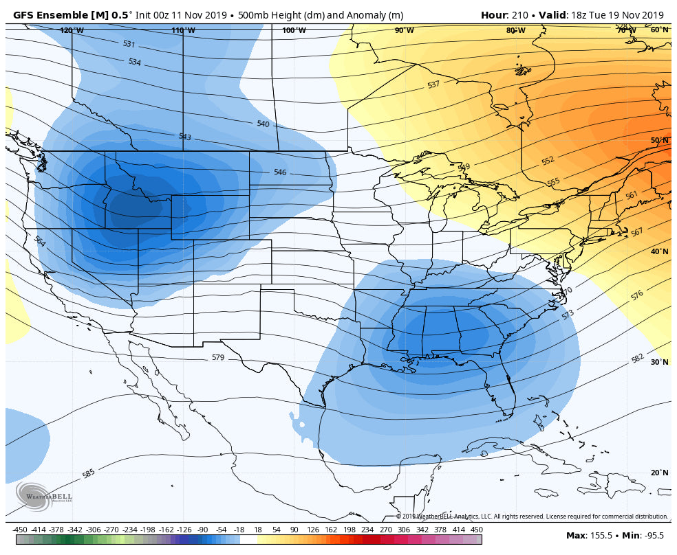
High pressure will return this week before low pressure is likely to settle in towards the 18th of November timeframe. The Ensembles are getting more consistent that the stubborn ridge is going to break down in the next 7-8 days. Storms are likely to start rolling in from the Pacific Northwest and may bring appreciable amounts to some areas in the Rockies. The Sierra may also be in the hunt for some snowfall in the extended. It's definitely too early too forecast amounts or locations. Both the operational models and ensembles are onboard with these changes. Confidence is moderate at this time for this pattern change.
Below: The GFS being the most Optimistic on low pressure moving into the west near the November 18/19 time period. The Euro is onboard as well but a weaker overall signal.

Meanwhile, if you want to ride some deep powder, head to Northern Vermont right now. Double digits are likely to be falling focussing on the Greens and Adirondacks in Vermont and New York. Jay Peak, Whiteface, Stowe, Sugarbush and perhaps Mad River Glen (Wildcard). All are all good choices (Nothing is open, but this forecast lives vicariously as if it were mid winter). Lake induced snow bands will continue Tuesday afternoon and evening for some isolated areas near Burlington with very cold temperatures. Folks will be hiking on Tuesday morning and if lucky again Wednesday. Further south in New England, warm air pushes in Monday night lowering amounts at most ski areas for southern and central areas. That warm air will bring mixed precipitation in many areas at lower elevations and mostly snow at the summits. Amounts will be less the further south you travel. Perhaps Cannon or Wildcat get lucky being on the northern fringe of the cold/warm air by Tuesday afternoon (Wildcards).
Below: Warm air aloft moves up into southern New England Monday night lowering snow totals for many ski areas in central and southern areas. The northern Green and Adirondack mountains of Vermont will see much higher amounts where temps are colder (9-15). By Tuesday night all areas will be very cold with snow showers (Lake induced) will continue near Burlington. Double digit snowfalls in November are very rare for New England. The last time Vermont saw double digit snowfalls this early in the season was in 2002.
.png%5C%22)
Enjoy the powder everyone, especially if you are in New England!
Sign up for the Powder Concierge forecast service and receive a $75 off discount code for a Mountain Collective Pass!
Powderchaser Steve


