Fall begins officially on Saturday, however Mother Nature will be teasing the Northern Rockies with 10-15 degree below normal temps and some snowfall above 6,000 feet up north and 8,000 feet further south. We feel that this might be the 1st official kick off seeing the chance of lower elevation snow and valley freezes. Snow will begin as early as Thursday in Montana and may continue, albeit light into Friday night further south.
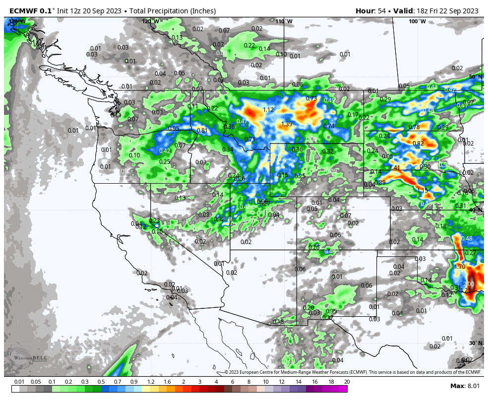
While we are not talking big numbers, the models show up to an inch of precipitation in some areas by late Friday. Totals will be very elevation dependent with perhaps 1-2 inches at mountain passes, and 3-6 inches at the peaks. Some areas might see higher amounts especially above 9,000 feet (6-10 inches).
Below: You can see the cold front highlighting the PNW, Canada, and the Northern Rockies late Thursday night into Saturday. These temps are hovering at -1C --2C at 10K feet so there will be some snow from 8-10K and possibly occasionally at 6-7K feet (Minor accumulation). You can see the coldest air getting washed out by Saturday with a slight warming trend in the Rockies.
Very cold air is noted to slam into the PNW by Saturday night (-6C at 10K) that will kick off another round of snow in BC and eventually the Rockies in the extended.

Below: You can see areas of high elevation snow from late Thursday to Friday favoring the Continental Divide from Montana (Glacier National Park), and areas along the MT-ID/WY border. If this was midwinter, I might be focussed a bit more on areas from Dubois Wyoming and north and just west of Red Lodge (MT/WY border) The upper peaks of the Madison Range (Big Sky, Bridger), Tetons and and the northern Wasatch in Utah will also see snow. Lesser amounts will fall south of the Wyoming/Utah line with the highest totals in Montana or northern Wyoming (Yellowstone) above 8K.

Below: Total precipitation is healthy Thursday to Saturday which leads us to believe it's possible some surprise upper mountain digits might be found especially northern regions (1 inch or water totals in many areas).
 Extended forecast shows unseasonably colder temps favoring the PNW, BC, and Alberta early next week. Some snow is possible in these regions that will eventually trickle into northern Rockies mid or late next week. Looking out to the 1st week of October (Low confidence 10-14 days out), there appears to be a deeper push of moisture that might bring more substantial snow favoring Canada and the northern areas of the Rockies (1st week of October)
Below: Low pressure noted over the PNW and Canada early next week with much colder than normal temps.

Below: Sneak peak with low confidence of a decent storm possible in the 1st few days of October.

Some might ask "does this early season snow have any resemblance of what the upcoming winter, El Niño will look like" There is very little correlation with early season snow and the majority of winter. In fact, from previous years of chasing powder, it is not uncommon for Canada and the Northern Rockies to be in the spotlight due to these cold fronts pushing in from the north, especially along the Divide.
We look forward to chasing powder with you this season! Please sign up for our concierge program if you want to be in the deepest resort or nail the best timing for storms all winter long. Promotion: Any new mid level or higher sign ups on the concierge prior to October 1st will receive a branded Powderchasers Tee shirt. Feel free to donate to Powderchasers, follow our social media, and purchase our swag.
Check out my Alaska Brown Bear Photos on Instagram @powderchasersteve
We hope to see you on the slopes soon!
Powderchaser Steve


