
Summary:
_______________________
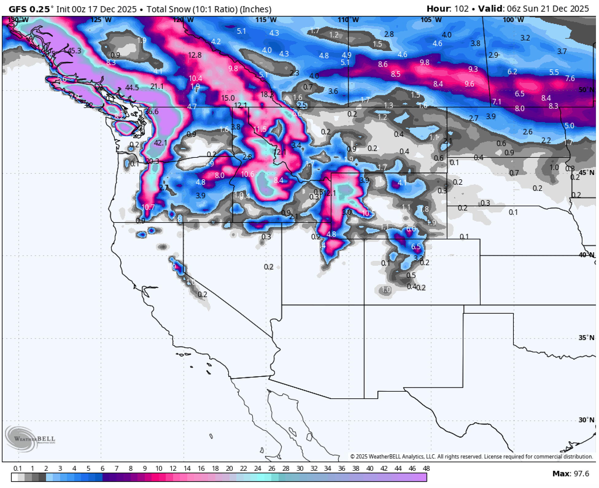
The West will finally see a return to snowfall this week as two storm systems, fueled by atmospheric rivers, move into the region. The first system arrives Tuesday night and will deliver up to 2.5 inches of liquid to the Pacific Northwest by the time the storm cycle concludes, with the majority falling as snow. Volcanic summits across the PNW could receive multiple feet, while most ski areas are expected to pick up 2+ feet by Sunday morning. A second storm will continue to feed moisture into the Pacific Northwest; however, it will favor the Northern Rockies, where portions of Idaho, Montana, and Wyoming could see up to 15 inches by Sunday morning. The Tuesday system will begin warm across much of the West, with rain and mixed precipitation likely at lower elevations and base areas. However, a strong cold front early Wednesday morning will rapidly lower snow levels to around 2,500 feet in the PNW, finally replacing rain with snow at resort elevations. British Columbia remains very active and continues to build on an exceptional start to the season. Colorado and Utah will largely be left with scraps. Looking ahead, scroll to the Extended section for an early look at additional storms lining up for next week.
Expected Snow Totals Through Sunday morning:
____________________________________________
PNW:
Mt. Baker Ski Area: 15-20”
Timberline: 10-18”
Crystal: 12-18”
Stevens Pass: 12-16”
Snoqualmie: 12-16”
Utah:
Solitude/Brighton: 5-8”
Alta/Bird: 5-8”
Park City/Deer Valley: 4-6”
Northern Rockies:
Tetons: 10-15”
Bridger: 2-5”
Big sky: 3-7”
SunValley: 4-8”
Canada:
Whistler: 15-18”
Fernie: 12-16”
Revy: 12-15”
Kicking Horse: 8-12”
Sunshine/Bnaff: 10-15”
Colorado:
Vail: 1-3”
Breck: 1-3”
A-Basin: 1-3”
Winter Park: 1-3”
Steamboat: 3-7”
Below: The first low-pressure system moves in Tuesday evening, followed closely by a stronger second storm arriving early Friday morning.

Below: The cold front enters the PNW early Wednesday morning, with snow levels dropping to around 2,500ft, well below base areas. However, a wintry mix and rain are expected to continue until 2 am on Wednesday, after which the moisture will turn to all snow. A second wave of cold air will enter the region late Friday night. In the northern Rockies, that cold air wave first appears early Thursday morning. ID/MT/WY will all see a brief warmup Thursday night through midday Friday before the next wave of cold air hits.

Below: An atmospheric river aims at the PNW with liquid totals of 6” by Sunday (pictured in light grey/brown). This theoretically means 60” of snow could fall; however, it will not, as this storm will mainly be rain to start. The majority of this liquid total will thankfully fall as snow, and Mt. Baker summit could see 30” by Sunday morning. The Northern Rockies, as well as Utah, are expected to pick up 1-1.5” of liquid.

PNW: (Washington / Oregon)
____________________________
The most significant factor this weekend will be the wind, with gusts of 100+ mph and sustained winds of 60+. It is essential to note that, due to flooding, most resorts will not open until after this weekend, as WSDOT still needs to clear roads and some resorts have lost infrastructure. A wintry mix and rain are expected to continue until 2 am on Wednesday, after which the moisture will turn to all snow. The cold front enters the PNW early Wednesday morning, with snow levels dropping to around 2,500ft, well below base areas. This storm is finally going to stay cold throughout the entire storm cycle, and the majority of this liquid total will thankfully fall as snow. In terms of totals, most ski areas will be in the 10-20” range, and the summit of Mt. Baker ski area could potentially see 30” by Sunday morning.
Northern Rockies: (Montana / Wyoming /Idaho)
_________________________________________
In the Northern Rockies, the storm will kick off late Tuesday night and continue through Wednesday. This storm could start as a wintry mix and even rain in areas under 7,000ft, but it will quickly turn to snow early Thursday morning as a cold front moves in. There will be another brief warmup period Thursday night through Friday afternoon, which could again bring mixing and even rain to base areas. However, anything above 7,200 ft will remain as snow. The heaviest snow will fall on Friday evening into Saturday morning, with 1-2 inches per hour possible. Winds will also be a factor, with sustained winds of 20-40mph expected, with gusts up to 80mph.
Utah:
_________
Moisture is expected to move in early Wednesday morning; however, this will be a quick event, and the best chance of significant accumulation will be on Friday afternoon. Cold air will move into the region on Wednesday afternoon and exit by Thursday evening before the next wave of cold air arrives Saturday morning. Snow levels will be right around 8,000ft, which is where Alta's base is located, meaning there is a chance of a wintry mix.
Extended:
_______________
Canada, the Northern Rockies, and California are all expected to be hit by multiple storms next week, kicking off Sunday night.
OUR GOLD SPONSORS


Forecaster: Mark Mazzatta @mmmazzatta
HELP US OUT- Please support your love of powder and our free forecasts with a donation here, or join our concierge program. We have merch on the website.


