
Snow is continuing in the Pacific Northwest, with some telemetry sites up to 3 feet in the past 5 days in the northern Washington Cascades. Whistler is about to turn on the firehose again with colder air and snow likley to blanket the bases. The PNW will be opening very soon, with Crystal popping the ropes last Saturday. Whistler will finally see significant base elevation snow with the interior BC mountains grabbing moderate totals.
The Jet stream has dropped further south, allowing warm Pacific moisture (Atmospheric River) originating from Hawaii to move into the Sierra, peaking Sunday/Monday and again for Christmas Eve and extending into the end of the week. Snow levels in the Sierra will be very high with storm #1 from Sunday to Monday. Storm #2 enters the west midweek with colder air from the Sierra that trickles into the Rockies (slightly warmer). The Sierra could end up with 5-7 feet of snow!
SUPPORT OUR GOLD SPONSORS


Highlights
* BC and the PNW stay cold with snow continuing for much of the upcoming week.
* Warm storm aimed at the Sierra, Idaho, Wyoming, Sunday-Monday. Rain at lower elevations.
* Colder air for Santa (XMAS eve) headed south for the northern Sierra
* Colder midweek storm likley for the Rockies and Idaho, favoring the northern regions.
* Weekly snow totals in the Sierra will exceed 5-6 feet in many locations.
*Santa is going to have a nice run with his sled for Christmas, starting in the PNW and heading into the Sierra before heading east into the Rockies.
Below: Low-pressure slides south this week into the Sierra and streams mositure north with SW flow into the Rockies. The low extends into the PNW initially with colder air. You can see the blue line (Cold front) on this map staying north and dipping further south by November 24th.

Below: 10K foot temps from Tuesday (12/23)-Sunday (12/28). Cold air stays north until the 24th, when snow levels drop to around 4500 feet in the northern Sierra and 5500 feet further south (Mammoth). The cold air will set off a good round of steady snowfall for the lower elevations of most ski resorts just in time for Christmas.

Below: The American GFS has some decent totals both north of Lake Tahoe and further south toward Kirkwood and just north of Mammoth (Mammoth might be too far south)

Below: The European model pushes the snowfall from the warm first storm (Sunday/Monday) further north near Lake Tahoe, extending to Kirkwood just south of the lake. The short-term models split the differences between these 2 and show equal amounts of moisture for both ranges. It is fair to forecast 6-11 inches for the Sierra Range for the Sunday/Monday event above 8,000 feet. Some spots, above 9500, could see higher totals. If the European model proves correct, the snowfall will mainly impact the ski areas closest to Lake Tahoe to as far south as Kirkwood.

Below: Storm #1 totals in the west by midweek
The overall picture of events shows snowfall in the west in full gear for the Cascades at the beginning of this loop (Sunday, 12/21) through Monday. Density will be very good in the PNW and Canada for this first wave. Snow begins on this map in the Sierra late Sunday/Monday above 8,000 feet. Idaho and the northern Rockies seem favored also (Warm storm). Density in the Idaho mountains (Sun Valley can be favored with these moist systems moving up from the Sierra) will be very high (Wet snow). The Tetons will see rain below 7,000 feet (Wet base building snow from mid to upper mountain of JHMR). Targhee might stay all snow, having a higher base elevation.

Below: This Map (10K) is from Monday night to early Sunday (12/28). The deep greens (Colder air) are in the northern tier States initially until midweek when the Sierra gets into the colder action. Meanwhile, in the Rockies, you can see above freezing temps early next week at 10K slowly trickling down by late Wednesday or Thursday (12/25). The northern regions of Idaho and Montana might stay in the colder sector for much of the week, especially the PNW and Canada.

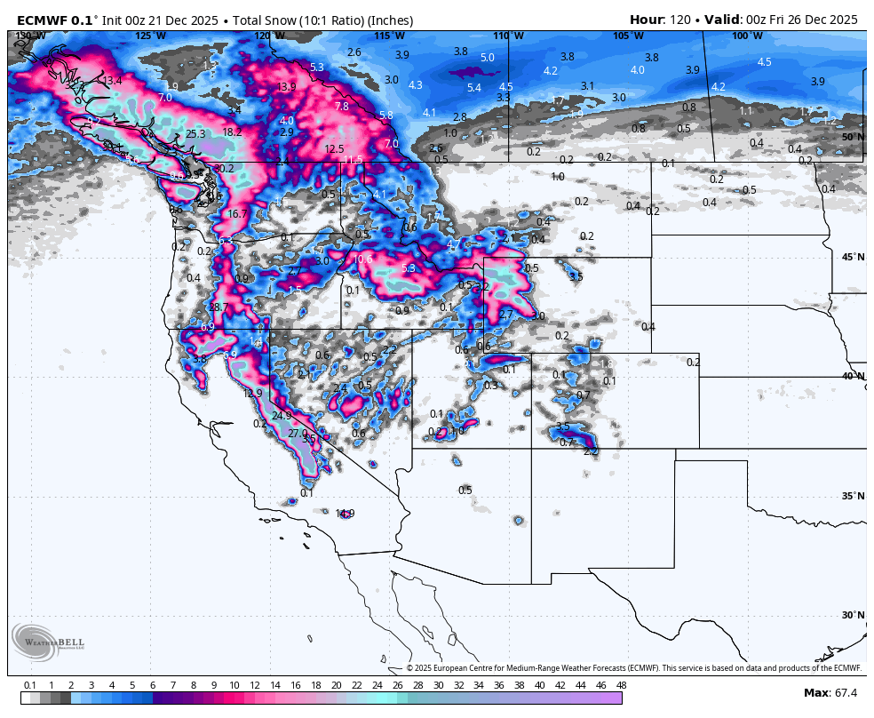
Storm #1 and #2 combined (Early and midweek) totals by 12/25.
Below are snow totals for Christmas Day in the west. The 2nd surge of moisture with colder air hits the Sierra, pushing snow totals to 3-4 feet above 9000 feet, and likely 1-2 feet below 7,000 feet (First storm is very warm). Lake level snow is likley with the midweek storm. Some models show higher totals above 9,000 feet by the end of next week (75 plus inches in the Sierra).
Aside from the Cascades and BC (Getting deep) on this map, most of this snow comes in warm and heavy initially in the Rockies, with storm #2 midweek providing lighter density snow (Idaho, Tetons, etc.).
Wyoming and Idaho seem well-positioned here for both storms (Warm initially), with Utah on the southern edge. Colorado might grab scraps with some higher totals showing up in the southern mountains (TBD).

Below: Total snowfall in the Sierra combined with storm #1 (Warm) and storm #2 midweek through 12/27. These totals seem reasonable as splitting the differences of many models, some showing 75-90 inches, where the new experimental NBM shows 4-5 feet. The elevations below 8500will have less snow due to the warm nature of storm #1 Sunday/Monday.

Below: The period from late Saturday (12/27) to Tuesday 12/30) shows another push of moisture from the Sierra and perhaps into Utah/Colorado and the Four Corners.

Please help us out by considering some of our high-quality merch for Xmas in our powderchaser store.
Forecaster: Powderchaser Steve @Powderchasersteve
HELP US OUT- Please support your love of powder and our free forecasts with a donation here, or join our concierge program. We have merch on the website.


