We are currently on the chase so this forecast will be brief. A more detailed forecast will be issued on Saturday or Sunday.
The Sierra will score 9-14 inches Friday night into Saturday (Good timing). The northern areas are slightly favored.
Rockies:
Friday totals came in as planned with significantly higher totals for Steamboat (8-10 inches) as discussed yesterday. Brighton in BCC beat out LCC for the morning report. SW winds and and a northern Trajectory in the low was evident on the models yesterday. During the day LCC grabbed another 5-6 inches so storm totals are approaching 11 inches. The northern Wasatch won the early Friday game as forecasted, Powder Mountain with 9 inches. JHMR had 9-11 inches by opening tram. Targhee had less (SW winds don't favor Targhee).
The quick chase forecast. Extended Forecast on a later post.
Looking at models, the Tetons will score again on Friday night (5-9 inches) with another 3-7 during Saturday. The Wasatch of Utah comes up deep beginning at 10 AM Saturday. Not much overnight snow, but a good storm ski day for the PM. NW winds might favor the Cottonwoods (LCC) in the afternoon, however SW flow early Saturday should produce higher early totals for Big Cottonwood, PCMR, Snowbasin. While the Tetons get more AM -1st chair snow, the Wasatch should catch up by PM.
For Colorado Steamboat is a clear favorite through Sunday. The models show perhaps another 9-15 inches through late Saturday night. Other spots to watch will be the western slope such as Powderhorn and areas south towards Crested Butte. The deepest totals might skim just west of Aspen (Wildcard for deep snow), and drop south into Gunny. It will be snowing Saturday morning north or along I-70 dropping south by late AM or early PM. Heavy snow is likely for the San Juan Range including Silverton, Telluride, Wolf Creek, Purgatory by Sunday morning (12-16 inches). Ride north on Saturday and drop south on Sunday? Steamboat might continue to nab some snowfall on Saturday night. For the rest of the I-70 corridor east towards Vail, Summit County amounts Saturday AM through Sunday AM will range from 5-9 inches. The models show higher amounts towards Grand County (Winter Park wildcard), and Rocky Mountain National Park (Wildcard). I would also watch Berthoud Pass however confidence is less than the areas further north. Lets' hope the I-70 corridor over performs. Breck Sometimes score good powder on SW flow (Sneaks up the back door from the south).
Below: Steamboat Cam at 8PM Friday MST.

The PNW Is getting a very rare cold and deep storm that will impact the urban corridors on Saturday. Very deep snow is possible in the southern metro areas near Pierce County extending north into Seattle. The storm favored the southern areas. Crystal is a wildcard pick for 5-15 inches. Wide spread due to models not handling the easterly push of winds and very cold air. Its possible that White Pass just south of Crystal come up with higher amounts. The Oregon Cascades will get crushed on Saturday (1-2 feet of blower).
Below: Look at this amazing temperature drop at Crystal just in the past few hours from post time! OMG. and snowing currently. (Post time is 8PM Friday MST).

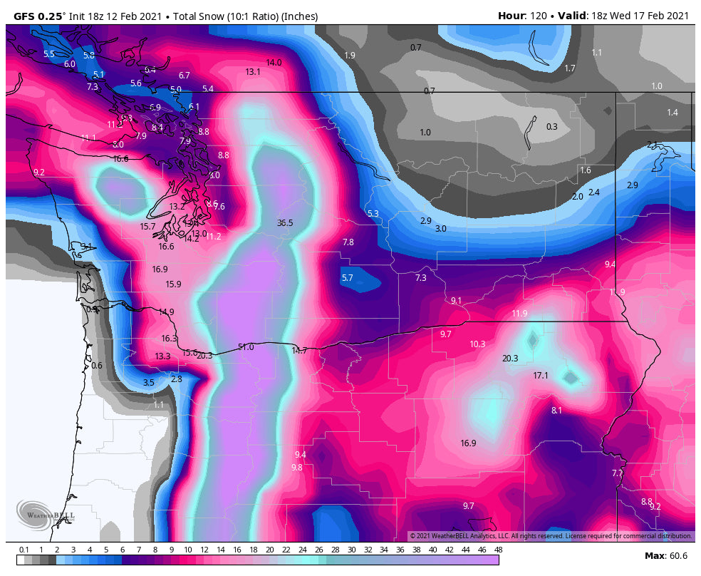
Another storm moves into the Cascades Sunday/Monday with snow falling heavily along the Cascade Ranges. This will add another 1-2 feet of powder to many ski areas from Oregon through central and perhaps northern Washington. Many areas will score deep snow! Temps warm with this storm but it's still cold enough for all snow at the bases.
Below: Total snowfall from Saturday to Wednesday for the PNW. 3-5 feet!

More info will follow on a later post.
Please consider a donation to support our forecasts.
Powderchaser Steve
Enjoy the powder everyone.
Powderchaser Steve


