This morning, resorts across Colorado are reporting 5-12” of fresh snow. Check out some reported totals below:
- Steamboat: 12”
- Purgatory: 8”
- Ajax: 7”
- Silverton: 7”
- Beaver Creek: 6”
- Winter Park: 6”
- Wolf Creek: 6”
- Buttermilk: 5”
- Snowmass: 5”
Precipitation will continue to linger throughout the day today, bringing 1-4” over the course of the ski day to resorts in the central and northern mountains. Winds will be out of the northwest, which is optimal for resorts like Steamboat,Vail, and Aspen; look out for these areas to exceed the forecast especially near Steamboat (5-8 additional)
Meanwhile in Utah, 10-15 inches fell for many areas of the Wasatch Monday and another 7-14 inches has landed for Tuesday (We were not forecasting this final wave). It is still snowing. 3 day totals are nearly 35 inches for some locations of northern Utah.

Showers will continue through Tuesday afternoon and into the night, with heavier snowfall the further north you go. By Wednesday morning, resorts in the central and northern mountains can expect to see an additional 2-4” from when the lifts closed on Tuesday.
After this storm finishes dropping snow on Colorado, it will move east into New England starting on Thursday morning. This may shape up to be the biggest storm of the season (Have they had any storms) so far for the East. Snowfall will begin in Pennsylvania and southern New York before beginning to push into ski country by Thursday evening. This will then track from southern-central Vermont through the central mountains of New Hampshire and into most of central and northern Maine by Friday-Saturday.
By Friday morning, here are what I see as realistic totals at a few resorts across the region:
- Killington: 7-9”
- Smuggler’s Notch: 3-5”
- Sunday River: 5-7”
- Whiteface: 8-10”
- Mt. Snow: 12-15”
Precipitation will continue throughout the day on Friday and into Saturday. By Saturday morning, lingering precipitation will be relegated to northern Vermont and New Hampshire. By Saturday morning, most resorts will have picked up another 4-8” with the best chase targets in New York and southern Vermont extending into central NH and a wide area of Maine. We need to update this forecast as we get closer (More detail). This is a warm storm with high density and even the chance of a bit of rain mixed at areas closer to the coast.
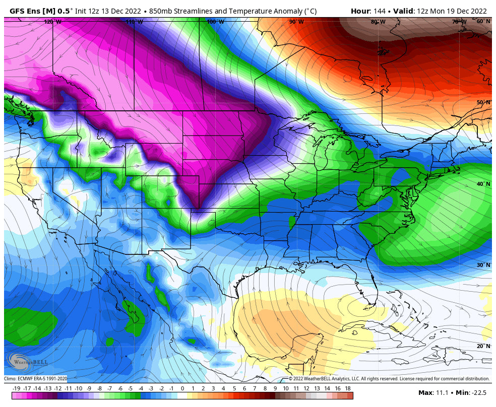
Meanwhile in the west, a mild ridge will build, blocking moisture from reaching the coast. However, the good news is that this high-pressure airmass is quite cold and will allow the snow to remain cold and high-quality. As you can see from the lower atmosphere temperature anomalies on the 19th, this air centered over Canada and the upper Midwest is extremely cold:

Below: Extremely cold temps noted as we approach the middle to end of next week (Map is for December 22nd) with 10K foot temps in the -35C range (-31F). BRRR

During this stretch, most of the west will remain dry but very cold. Models are hinting at some storminess around the 18th/19th/20th, but it’s too soon to tell what areas will be most favored by this system. As of right now, it’s looking like 1-2” of moisture (10-30” of snow) for Washington and Oregon. The storm looks quite cold. Probably nothing huge, but something to keep an eye on for sure. As you can see before, all ensemble clusters are forecasting stormy weather in the Pacific Northwest and upper Midwest, but none are currently showing those conditions extending south into California:
 Powderchasers and our forecast staff is supported by our readership, so if you have not donated, please do so here or join our powder concierge program where we provide 1:1 trip planning for chasing, last-minute custom forecasts, and the best pow day of your life. Support our sponsors and be sure to follow our Instagram and Facebook page @powderchasers.


