
The models are remaining bullish for a cutoff low to slowly enter the Four Corners on Friday. A low with Cold air from the north will merge with a southern moist system pushing ample moisture from the Baja into New Mexico and Colorado. Moisture stretches from metro areas in Texas all the way to New England, where cities
The Real Deal!
Finally, we have a very legit storm to talk about for the west; however, it's isolated to only a few areas. Southern cut-off lows are hard to forecast since any deviation of track can make a big difference in just 20 miles in snowfall totals.
SUPPORT OUR GOLD SPONSORS


Below: The merge of a moisture-laden system in the south with a cold, dry trough in the north sweeping into the southern and central Rockies.

The models on Thursday morning are in decent agreement that snow will begin as early as 2-3 PM Friday over western Colorado with W, SW flow (Aspen-Crested Butte seems to be initially favored). Moisture will begin to stream north to the I-70 corridor overnight Friday, albeit slightly lower intensity than the central or southern mountains. NW flow over the I-70 corridor should still produce decent totals from Aspen to Summit County, while North flow further east can also do well for areas like Winter Park. SW flow in the southern areas of the State will crank out impressive totals into late Saturday/Sunday.
Bottom Line: Multiple wind directions favor several areas of Colorado and New Mexico. WSW winds are also seen over Gunnison County (Crested Butte), which leads me to believe they will also grab higher totals than neighbors further north. Wolf Creek and areas south into New Mexico stand the highest odds of high-end double digits from this storm.
Below: Wind directions early Saturday favor multiple ski areas in Colorado, where most of you will wake up to powder. The southern mountains of Colorado have a slower start time (Later Friday night into Saturday morning), so storm skiing might be on the menu there as well as in New Mexico, which peaks Saturday/Sunday.

Early estimates on Powder?
Northern Mountains near I-70 (7-11 inches) by Saturday morning (Vail, Summit County)
Aspen/Crested Butte- Central mountains (9-15inches) by Saturday morning
North of I-70 Front Range (WP) (5-9 inches) by Saturday morning. Less further north to Steamboat.
Southern Mountains- Wolf Creek (10-22 inch totals by late Saturday night). Telluride (5-10), Silverton (7-14)
New Mexico (Taos, Angel Fire, Santa Fe, Pajarito) 10-20 inches (Saturday AM to late Saturday PM).
Ski Apache (Southern New Mexico) 20-28 inches. For Ski Apache's history and overview, you can view this interesting info here
You might be able to ride in New Mexico on both Saturday and Sunday for freshies on this storm?
Below: Arctic cold front pushing south from Friday to Sunday morning over the west. This cold air comes in roughly 1/2-3/4 way through the storm totals, so initial powder will be a bit denser but right side up (Cold blower on top). The cold front also might veer winds more northerly, which will reduce intensity over I-70 at some point Saturday. Winds stay SW in the southern mountains until Sunday.

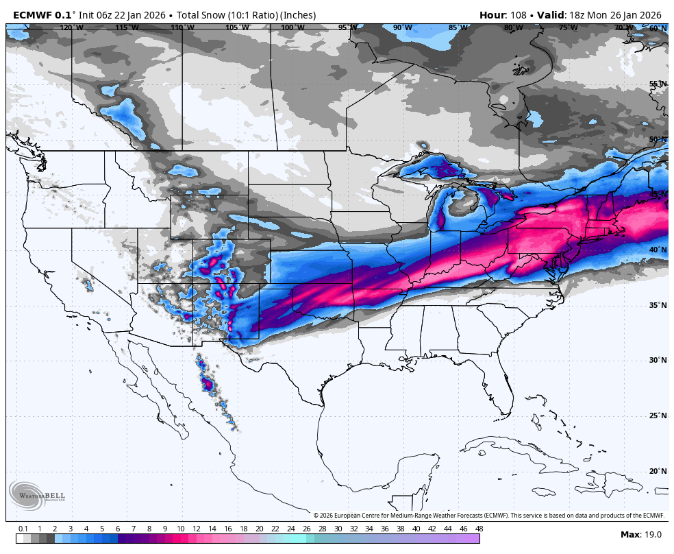
Below: Total snowfall at 10:1 ratios (1 inch of liquid being 10 inches of snow) through Sunday morning. The majority of the snow in the northern areas will fall from Friday PM to Saturday AM. The majority further south lands later Friday night into late Saturday. Snow could continue in a few southern mountains into Sunday.

Below: It is important to show water totals since ratios will be higher (Snow to liquid). You can see over an inch of water for the southern mountains of Colorado (Wolf Creek) extending into New Mexico. These higher totals are also showing up just south of Aspen (Gunnison County). With cold air pushing in on the latter half of the storm, I bumped up the snow totals per my estimates above with ratios in the 15:1 or higher ranges.

New England Chase for Monday
In the East, the models are still in flux, with most showing a good surge of snowfall extending well into southern and central Vermont. The GFS is still keeping the highest totals near and south of the MA/VT borders. Many ski areas will be getting snowfall in New England, peaking Sunday night into Monday.
Below: European model showing significant storm totals for New England through Monday afternoon. Metro areas of the East Coast will be slammed (10-20 inches)

Below: The GFS models (Pessimist) keep the highest totals further south in New England, resulting in less snow for VT/NH. This model is the outlier in most data I have looked at on Thursday morning.

Below: The Canadian model is in line with the optimistic European model above.

Chases in the west and east
Friday PM (last chair)- Aspen or Crested Butte (Outside chance of 2-6 by the end of the day).
Saturday AM- 5-10 inches I-70 Corridor. Central mountains (CB, Aspen 9-16). Wolf Creek- Deep to getting deeper by the end of the day. Telluride (Wildcard). Silverton and Purgatory (Moderate to perhaps low-end deep). New Mexico (Starts with 4-7 and finishes with 10-15 in many areas). Monarch is a wildcard.
Sunday: New Mexico might still be in the game with snow showers continuing Saturday night. Very deep conditions will be found at Ski Apache (Southern NM). New terrain openings at many ski resorts will occur on Sunday. New terrain openings in Colorado are also likley.
Monday: Chase to New England. High confidence in the Berkshires and all southern areas of New England. 75% confidence in double digits extending into Southern and central VT/NH/ME. 45% confident in double digits near Stowe and Jay Peak.
Extended Powcast
The extended shows a continued chance of snow showers over New England, with nothing overly exciting for the west. There is a hint of 2 systems moving down the California coast with increasing odds of another storm sweeping into the southern tier areas of the West.
7 Day extended beginning early next week
Below: Tuesday, January 27 to Tuesday, February 3rd. Generally, high pressure in the west, aside from a low-pressure system that enters the Sierra and may drag south along the coast later next week. That takes a southerly track over Mexico. Another low is also showing up behind it near February 3rd (Same track).

Below: 24-hour moving snowfall map from Tuesday (1/27) to Wednesday (2/4). You can see the chances of some snow for the Sierra quickly weakening before heading for Texas. Some scraps are noted in the northern Rockies. New England seems to stay active with weak waves.

Forecaster: Powderchaser Steve @powderchasersteve (Instagram)


