
A closed low will approach the Four Corners late Friday and slowly drag over New Mexico by Saturday morning. This low will combine with a system further north that has arctic air. The combination of both systems will bring a cold storm to areas of the southern Rockies and spread east over multiple States in the central US (TX, OK, AR, TN, etc.), raising havoc to metro areas not used to seeing the deep white.


Our Powder alert is for New Mexico and Colorado, where the southern and central mountains will be favored to grab 10-20 inches of snow. The models are both strengthening and slowing the timing (common for southern lows to stall and slow).
Below: Total snowfall in the US through Sunday night. You can see that narrow line of heavy snowfall stretching from CO/NM into the metro areas of the central US. Scattered snow showers are likley in central or southern Utah and Arizona as well.

Some expected snow totals through Sunday
Ski Apache: 15-25 inches
Taos: 9-13 inches
Angel Fire: 6-11 inches
Pajarita: 8-11 inches
Ski Santa Fe: 9-12 inches
Wolf Creek: 10-18 inches
Silverton: 7-15 inches
Purgatory: 7-15 inches
Crested Butte: 9-15 inches
Telluride: 6-12 inches
Aspen: 7-13 inches
Vail: 5-9 inches
Breckenridge: 5-10 inches
Winter Park: 4-7 inches
Nashville, TN- 10 inches!
Below: Arctic air moving from north to south Friday-Sunday. The majority of the snow will fall just before the coldest air; however, since the storm is coming in initially a bit warmer, and finishing cold (Right Side Up), it should ski really well. Cold air might enhance snowfall in some areas as well (N, NW flow).

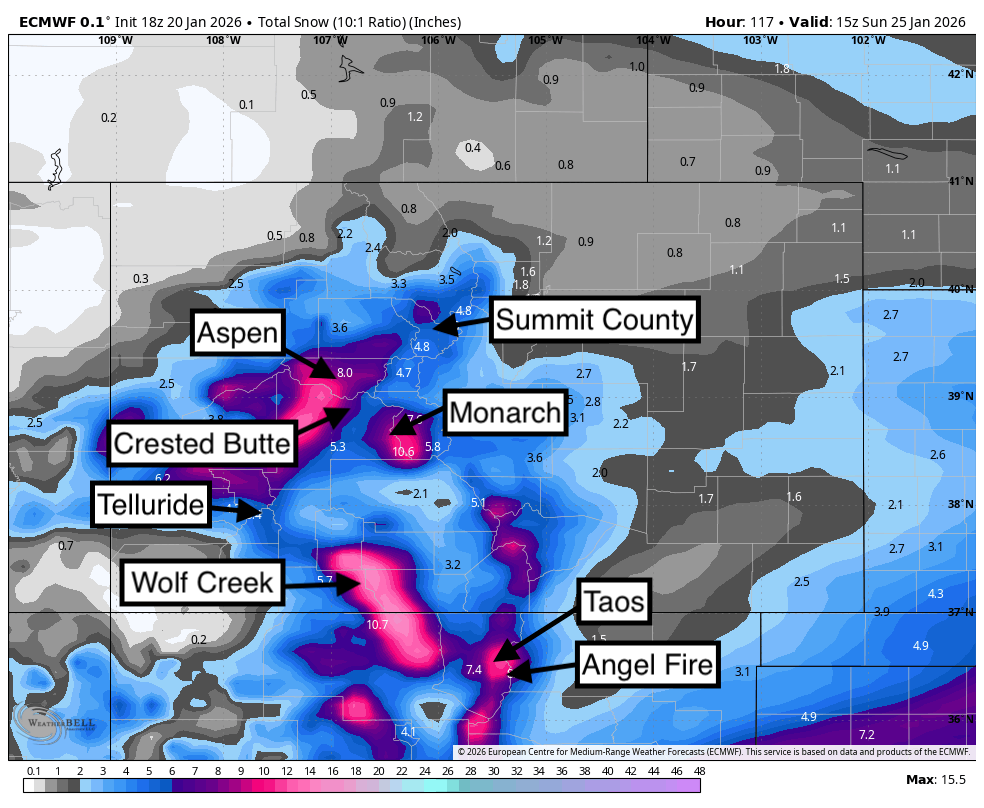
Below: Some projected deep spots per the European model. There is still some uncertainty on how far north this storm will travel, with a few models showing less towards Aspen and the I-70 corridor. We still have decent confidence in moderate totals for Summit County and perhaps heavier totals from Aspen and south. The good news is that the trend overall is for a longer and slower storm track.


Sponsor Alert- New Mexico skiers - DownSlope Mobile tune shop can get your gear ready now, and tune at your house with their amazing mobile tune shop at your curbside.

Below: Low pressure over the southern US waters picks up moisture over BAJA before sweeping north and merging with the cold low in the north. Winds initially from the SW (Moisture phase) switch to the N, or NW as the cold low merges. NW winds behind the initial moisture surge might bring some upside to areas like Taos or even the I-70 corridor. (SW, N, and NW flow=most mountain ranges will grab some powder).

Timing: Models show snow ramping up along I-70 (light to moderate) by 2 PM Friday. Moisture increases from Aspen to Crested Butte Friday night into Saturday morning. The southern mountains from Telluride to Wolf Creek crank out early Saturday morning (4 AM) through the day/evening (Saturday). New Mexico sees its best chase late Saturday or early Sunday.
Please help us out if you read our free forecasts by considering some of our high-quality merchandise in our powderchaser store. or Concierge.
HELP US OUT- Please support your love of powder and our free forecasts with a donation here, or join our concierge program. We have merch on the website.
We appreciate the support.
Forecaster: Powderchaser Steve @powderchasersteve (Insta).

Forecaster: Powderchaser Steve. @powderchasersteve (Instagram)


