Summary:
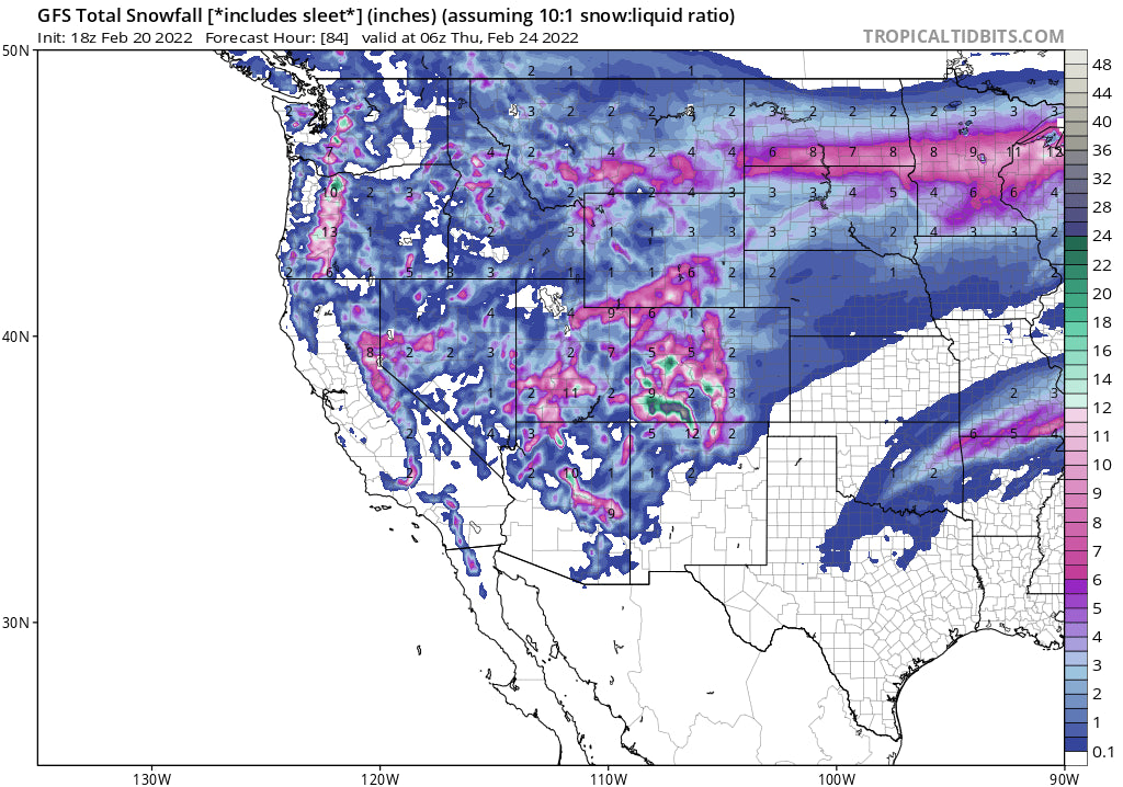
Heavy snow continues in some areas of the NW, while the next deepest spots to chase powder may land in the southern Rockies in the next 4 days. The Tetons, Wasatch are wildcards. Finally snow for the Sierra and the desert Southwest including AZ.
Forecast:
Today's chase took us to Stevens Pass (Love the name) where 20 inches fell overnight. Temps created the perfect powder cushion (Mid 20's summit). The 4 AM wake-up call was a tough decision between Crystal (8-9 inches and still snowing) and Alpental with 12 plus. The 4AM chase meeting with my trusty forecaster Luke included thoughts of crust underneath, what will open, temps and wind. We chose Stevens due to lower winds (Crystal had gusts in the 50s), deeper snow but scored low in the \what will open category\".
Stevens delivered 100% today with 22-24 inches by opening, no crust, and 100% of the mountain open by 9:30 AM. All overnight pow. Thank You Stevens (Pleasant Surprise).
Hats off to Stevens Pass Ski Patrol, Operations, and all those great employees that made it happen. By 10 AM the primary back side chair that connects with the Front Side Double Diamond lift broke down forcing us to hike for the rest of the morning. That chair spun again by 11;30AM.
Below: @powderchasersteve at Stevens Pass early Sunday morning (All overnight pow)

If you want to chase powder and score the deepest snow sign up for our Concierge program which also supports Powderchasers! You can also donate to us here. Also, there are still a few open seats on Alaska Backcountry Guides in March where near record snow totals have been met in many areas. Conditions could be epic in AK this season.
Moisture will increase for Oregon Sunday night with 12 plus inches likely for most mountain ranges favoring the northern regions. Mt Bachelor should see decent amounts also. In Washington, there are convergence zones forming from I-90 (Alpental) to Crystal. These bands will bring an intermittent steady burst of convective snow showers that can add 4-8 inches for Monday morning (Amounts are spotty and hard to pin down). Most of the chases should focus along I-90 or south. Oregon will likely be deeper. Some upside or downside surprises in WA due to the spotty and convective nature of the snow showers through early Monday (4-12).
Below: The Cascades will see decent snow Sunday night favoring Oregon with Crystal or White Pass wildcards (Convergence zones Sunday night).

In summarizing the deepest snow, look for moderate amounts near Bozeman MT, (Big Sky and Bridger), and the Tetons through Monday. Expect 3-7 inches for these areas with perhaps higher amounts in the Tetons (Monday freshies). Snow will also be falling in the Sierra Monday night with 6-11 inches possibly favoring the Lake Tahoe Region (Ride Tuesday morning). Colorado gets into the action Monday with peak snowfall noted late PM to Tuesday morning. The highest amounts are noted just north of Steamboat (Wyoming border) and in the southern San Juan Range (Eastern sections towards Wolf Creek Pass or Purgatory). These areas can land 6-12 inches for fresh turns by Tuesday. Further east the Front Range Resorts closest to Denver should land 3-7 inches with a bit of skunk hole for Summit County (Snow increases Tuesday afternoon to Wednesday). Aspen, Crested Butte, and Monarch are solid wildcards Tuesday (Moderate snow) and worth watching. The southern mountains will be deeper. Steamboat might be worth watching also but less optimisitc.
Below: The Sierra grabs a moderate storm Monday night to Tuesday. Woo Hoo!

Below: Total snow for Colorado through Wednesday morning showing impressive totals in the San Juan Range with decent amounts further north favoring the western corridor including Crested Butte and Aspen. Higher totals are likely with the colder temps and higher snow ratios!

The Wasatch shows steady snowfall albeit light intensity from Monday late AM to Wednesday night. It's likely you will grab 2-5 inches each day with totals in the 8-14 inch range by midweek (no single deep dump). Its a slow freight train so conditons will continue to get better each day. Totals could be decent early next week.
Below: Total snowfall for Wyoming and Utah through Wednesday morning. Colder temps and higher ratios will bring higher amounts (More snow per inch of water). Map is 10:1

Snow increases in Arizona (Arizona Snowbowl) Tuesday night into Wednesday. 18-24 inches are possible for northern AZ. Intensity will increase in Colorado Tuesday night to Thursday with additional moderate 24 hours periods each day. Some of this moisture may work its way further north along I-70 continuing to build snow totals slowly (Summit County, Eagle County worth watching, but areas west or south might be deeper).
Below: University of Utah Ensemble averages showing very significant dump for Arizona Snowbowl Tuesday to Wednesday (2 feet plus is likely Tuesday-Wednesday night).

Extended
Snow continuing Tuesday night to Thursday will ramp up snow totals for the San Juan Ranges. New Mexico looks best near Taos in the late Wednesday to Thursday time period. Some mountains in the 4 corners by Thursday (Southern Utah, Southern Colorado, Northern Arizona) will see 2-3 foot storm totals (Monday to Thursday). Tuesday PM to Thursday appears to be the best window for heavy pow.
Chases- Thoughts on the deepest chases.
Monday- Southern Cascades of WA or northern Oregon (Moderate or heavy snow) Tetons or Wasatch wildcards (Moderate).
Tuesday- Southern Colorado (Aspen or Crested Butte wildcards)
Wednesday (Northern Arizona- Arizona Snowbowl)- Snow continues in the 4 corners (Utah, CO, NM). Moderate snow along the I-70 Colorado corridor. Crested Butte and Aspen are also solid contendors.
Thursday- Northern New Mexico wildcard- Leftovers in the San Juans.
Please follow my Instagram page @powderchasersteve for the latest in powder and travel adventure.
See you on first chair again on Monday.
Powderchaser Steve


