
Summary:
Winter has a firm grip on the west at least through the 1st week of April with several storms to chase. These storms are impacting many areas beginning with Oregon, Sierra, and the Northern Rockies, followed by a cold PNW storm that blasts the region with pow you would find in January.
Announcement: Please donate for the season of reading our free forecasts! If you are still reading this, you most likely have scored powder from our forecasters. It is important that you support us for future broadcasts. We are looking for sponsors if you want your company, ski area, or ski products to be highlighted. We have a tremendous reach in this industry and our sponsor rates are very affordable. Any donation helps us to continue in the future. Sign up for our concierge program if you want to chase powder to the deepest places that we do (Often last minute). Email us for sponsorship opportunities at powderchasers1@gmail.com We have a 95% return rate from our sponsors.
Forecast:
The previous 24 hours brought epic lake effect totals to the northern Wasatch range near Ogden on Monday. 22 inches had fallen by 6 AM at Snowbasin with a storm total of 92 inches over the past several days. Snowbasin is now well over its annual record snowfall sitting at 506 inches for the season. I have never seen totals like the past previous days for the northern Wasatch. My last forecast was in the 5-10 inch range for most mountains from Ogden to the Cottonwoods with a caveat \"I have no idea what is going to happen\" Lake effect kicked in and remained stationary on the radar over Ogden and only moved slightly Monday morning sending scraps to other area mountains including the Cottonwoods who reported 5-10 inches. Snowbird had an unexpected road closure at 7:30 AM Monday leaving those lucky 50 folks in the tram line country club powder for 1-2 hours.
Sierra chases- Plus Oregon
The next several days bring many chase options with once again the Sierra taking the heap with 12-20 inches above 7,000 feet Tuesday to Wednesday. This storm has strong winds initially Tuesday decreasing for your 1st lifts on Wednesday. It's already dumping near Mt Shasta in the northern areas of California and will begin over northern Lake Tahoe just prior to the lifts opening Tuesday. Heavy snow will be ongoing Tuesday from mid-morning to the evening with the timing slightly slower over the southern ranges near Mammoth. Oregon will also see decent totals in the northern areas near Mt Hood (9-13) ( extending north over the eastern Cascades near Mission Ridge (3-5) in Washington. Unfortunately, snow does not push further north in Washington (Light snow for Stevens Pass) but that will all change In the extended forecast for the weekend. Bottom Line chase: Good storm totals for the Sierra, Northern California, and areas of Oregon. Temps drop during the storm making for primo quality. Winds decrease (Bonus). Timing is a bit of a day storm Tuesday with lighter totals Tuesday night with the exception of Mammoth who grabs snow a bit later Tuesday morning or early afternoon extending into Wednesday morning.
Below: decent totals are noted for the Sierra Range through late Tuesday night. The highest totals might land over Mammoth. Check out the pre-season renewal and pass rates below from IKON.

Below: You can see the cold front just reaching the crease of the Tahoe Basin by late Tuesday afternoon. Snow levels fall well below lake level and even into the lower elevations of the Reno- Carson areas. Quality will be high with this storm.

Rest of the west- Chases are abundant.
For the Rockies and Idaho, there is a decent moisture fetch with SW flow beginning over the Sawtooth range in Idaho including Sun Valley from Wednesday morning to Friday (11-15). The Tetons once again score continuous periods of light to moderate snow priming the backcountry with high quality (No single double-digit 12-hour event). The sum totals once again will likely range from 12-24 inches over the next 7 days. Conditions will once again be fantastic for the Tetons with the slow build-up of deepness each day.
Below: The ensembles are pretty confident of a steady slow build-up of Teton powder from Wednesday into early next week when rates might be heavier. This could equivocate to 30-plus inches of snow over a longer duration.

The Wasatch has potential with the models bringing in a moderate system for Wednesday night into Thursday under SW flow. This will favor BCC or areas north towards Ogden again. The models are split with the GFS and Euro showing different solutions (Ogden versus SLC mountains). The expectation at this point is a bit of favoritism to the northern Wasatch including areas towards Logan (Beaver) and southern Idaho (Pebble Creek). (GFS-NAM-favoring the north while the Euro still favors BCC or LCC). Current models show around 1/2 inch of moisture that should equivocate to 8-11 inches of snow. Higher amounts are possible for areas favored by SW flow (BCC, Snowbasin, Powder-Wildcard). Another colder system lands in the Wasatch range Thursday night which should be deeper and brings a more traditional colder NW flow. This is likely to be a good snow producer (9-17) and might fare best for Powder Mountain, the Canyons side of PCMR, and LCC. All mountains will benefit from this storm, especially Friday morning.
Montana is also showing up on the models favoring areas towards Big Sky at some point by especially Thursday (Moderate amounts likely).
Colorado likely lands 7-16 inches from Thursday to Friday as the main event. This system initially favors the western areas near Aspen extending to Crested Butte and the northern or southern San Juan Range Thursday morning. Heavy snow is likely Thursday for these regions that will eventually extend north and east to the I-70 corridor midday through Friday. SW winds will shift to the West or NW Friday bringing better odds of a decent powder day for much of northern Colorado. Vail Pass, Breckenridge, Loveland, WP, and Steamboat are all in the hunt for a powder day. Lighter snow continues along the Divide including Vail Pass Friday night into Saturday. The highest totals with this storm high occur on the western side of I-70. Of note on the chase, Telluride who often gets bypassed on southern storms could do really well with this storm starting out grabbing moderate snow Thursday under SW winds but cranking out bigger numbers under NW flow late Thursday or Friday.
Below: Ensemble ranges of multiple models for Vail Pass showing 5-10 inches of snow for Friday morning.

The extended feels more like a traditional January storm.
Mid-Winter conditions continue with a very cold airmass noted to enter the PNW this weekend. It's likely that ski resorts in the Cascades of Washington and Oregon score double digits, high quality peaking from late Friday night to Sunday. SW flow initially might land some decent totals near Mt Baker initially before winds shift to the W NW bringing in an equal chance of decent totals along most of the Cascade zones (Central and southern resorts favored) Snow levels will be well below the bases. Selkirk Powder Guides in Northern Idaho could do well with this storm (Cat skiing) from late Friday to Saturday.
Below: 48-hour precipitation is healthy for the PNW ending late Sunday. Stevens Pass, Crystal, White Pass, and most of Oregon should score double digits this weekend (High quality).

From the PNW this cold air and snow will take a northerly route, skimming the northern Sierra, and heading for the Northern Rockies. Areas of western Idaho (Brundage, Tam) extending east to the Tetons, southern Montana, and most of Northern Utah could score another great storm period by Saturday to Monday (North to south).
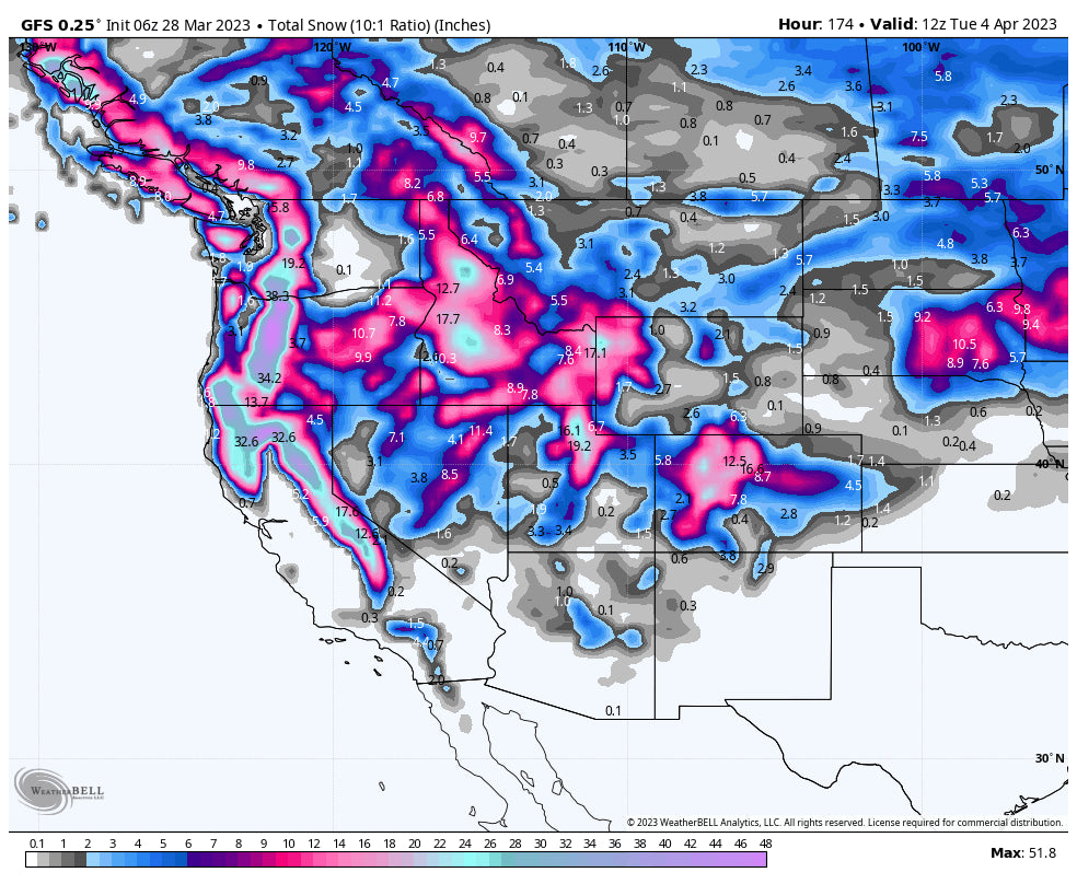
Below: 7-day snowfall over the west is plentiful. The Sierra grabs the majority mid-this week while the PNW and Northern Rockies slowly build this week and fire once again for the weekend and into early next week. Very cold air will keep you thinking it is January, not April. This is not an April fool's Joke!

Below: Total snowfall through Sunday for Idaho and Wyoming Is plentiful. Even Red Lodge Mountain which is still digging out from 45 inches scores.

Follow my adventures in the snow and international travel on Instagram @powderchasersteve
Enjoy the powder, everyone! I regret missing the 30-inch day at Snowbasin on Monday but instead enjoyed the country club at Snowbird for a few hours on Monday morning with 10-12 inches for dry density pow.
Powderchaser Steve


