
Welcome to the first official day of winter!
A more unsettled and wintry pattern is setting in across the West. The Pacific Northwest will see several waves of mountain snow and occasional lower-elevation rain through the upcoming week. California ranges trend wetter from midweek onward, with multiple bursts of snow for the Sierra. The Intermountain West, Utah, and Colorado will stay mild until a series of quick-moving storms arrives, bringing periodic snow for higher terrain and mix/rain at lower elevations. Winds will be blustery at times in the mountains and over certain passes, especially ahead of frontal passages. Keep an eye on day-to-day changes in snow levels as storms fluctuate in intensity.
NOTE: Please support Powderchasers with a donation, Merchandise purchase such as a hat or stickers, or sign up for our custom Concierge Powder Forecast Package,where we provide 1:1 phone and email support to get you to the deepest locations possible. You can gift a concierge package for the holidays! When chasing snow the Concierge gets you the best intel.
PACIFIC NORTHWEST

Forecast Discussion
-
Saturday through Monday
Multiple storms cross the region in fast succession. Snow levels initially hover 3000-5000 feet in Washington and Oregon, with generally light to moderate accumulations over the Cascades. Temperatures in lower elevations stay mild enough for rain or mixed precipitation. Expect breezy winds near the Cascade passes at times. -
Midweek
More Pacific moisture arrives and snow levels may climb briefly above pass level before lowering again. Storm systems become more active toward Wednesday and Thursday. This will favor enhanced snowfall in the Washington and northern Oregon Cascades, plus the volcanoes in southern Oregon, with occasional breaks between storms. -
Late Week
Mountain snow coverage ramps up again, possibly mixing with lower-elevation snow in interior valleys if cold air seeps in. Daily swings in temperature and precipitation intensity could create challenging travel over the passes, so plan accordingly.
Storm-by-Storm Resort Snowfall Totals
Below are the totals grouped by each storm’s approximate date range. Resorts are listed from highest forecast total to lowest for that event.
Storm 1: Saturday (12/21)-Sunday night (12/22)
- Timberline: 5-10"
- Stevens Pass: 5-9"
- Mt Bachelor: 2-5"
- Crystal Mountain: 1-3"
- Snoqualmie Pass: 1-3"
Storm 2: Monday night (12/23)-Saturday night (12/28) (mid to upper elevations)
- Timberline: 20-34"
- Stevens Pass: 20-34"
- Mt Bachelor: 17-30"
- Crystal Mountain: 22-38"
- Snoqualmie Pass: 12-21"
Single Extended Storm Window for Baker and Crystal: Saturday (12/21)-Saturday night (12/28)
- Baker: 39-67" (upper peaks).
- Whistler: 36-61"(mid to upper elevations)
CALIFORNIA

Forecast Discussion
-
This Weekend
Mostly dry and relatively mild conditions persist, except for minor snow chances Sunday. Snow levels near or above 7000 feet, with meager accumulations. -
Early to Midweek
A stronger system arrives Tuesday into Wednesday, boosting Sierra snowfall amounts, especially in the higher terrain from north of I-80 down to Mammoth. Winds turn gusty over the ridges. -
Late Week
Additional moisture pushes inland Thursday into Friday, bringing another round of moderate snowfall in the Sierra. Snow levels may oscillate from near 5500 ft to above 7000 ft depending on each wave. Travel could be impacted over mountain passes, especially if heavier bursts develop.
Storm-by-Storm Resort Snowfall Totals
Storm 1: Sunday (12/22)
- Kirkwood: 1-3"
- Heavenly: 0-2"
- Mammoth: 0-2"
- Sugar Bowl: 1-3"
- Palisades Tahoe: 0-2"
- Mt Rose: 0-1"
Storm 2: Monday (12/23) night-Tuesday night (12/24)
- Kirkwood: 10-17"
- Heavenly: 6-11"
- Sugar Bowl: 8-14"
- Palisades Tahoe: 8-15"
- Northstar: 4-9"
- Mt Rose: 4-8"
- Mammoth: 6-11"
Storm 3: Thursday (12/26)-Friday night (12/27) (some continuing into Saturday 12/28)
- Sugar Bowl: 8-15"
- Kirkwood: 9-16"
- Palisades Tahoe: 7-13"
- Northstar: 2-4" (with possible 0-2" extra Fri night)
- Mammoth: 3-6"
- Heavenly: 1-3" (plus possible extra 0-1" Fri night)
- Mt Rose: 1-2"
INTERMOUNTAIN WEST
Forecast Discussion
-
Weekend into Monday
A few weak disturbances brush Idaho and western Montana. These produce scattered light snow over favored mountain areas, with little impact on valleys. Snow levels remain 4000-6000 ft, occasionally dipping lower overnight. -
Midweek
A better shot of moisture approaches around Wednesday, fueling moderate snow in the northern Rockies. Southern Idaho mountains stand a decent chance for a fresh layer, while lower valleys might see wet flakes or a rain/snow mix. -
Late Week
Fast-moving waves continue the unsettled stretch. Temperatures stay mild, limiting valley accumulations, but the mountains could stack up more inches by next weekend. Expect periodic gusty winds over ridges and passes.
Storm-by-Storm Resort Snowfall Totals
Storm 1: Sunday night (12/22)-Monday (12/23) or Monday night (12/23) as indicated
- Grand Targhee: 4-9"
- Big Sky: 1-3"
- Jackson Hole: 3-6"
- Bridger Bowl: 0-1"
- Bogus Basin: 3-6"
- Selkirk Powder (Idaho) 4-8" (beginning Sunday night into Tuesday)
- Whitefish Mountain: 0-1"
- Sun Valley: 0-2" (Tue night)
- Steady scattered (for certain areas, see notes above)
(Note: Some resorts have multiple storms combined in the same date range, see below for extended or second storms.)
Storm 2: Late week (Dates vary)
- Grand Targhee (Wed 12/25 through Sat 12/28 night): 8-15"
- Selkirk Powder (Wed 12/25 night through Sat 12/28 night): 10-17"
- Bogus Basin (Wed 12/25 night-Fri 12/27 night): 7-13"
- Jackson Hole (Thu 12/26-Fri 12/27 night): 3-7"
- Big Sky (Wed 12/25 night-Thu 12/26 day): 0-2"
- Whitefish Mountain (Fri 12/27 day-night): 1-2"
- Sun Valley (Thu 12/26-Fri 12/27 night): 3-6"
UTAH

Forecast Discussion
-
Late Sunday into Monday
A quick-moving system may bring light snowfall to northern Utah’s higher elevations. Snow levels remain around 6000 ft or higher, keeping valley precipitation very limited. Winds pick up over exposed ridges on Sunday afternoon. -
Midweek
Another trough approaches Wednesday, bringing better chances of moderate snow accumulations to the Wasatch Range. Mixed precipitation in lower valleys is possible, but the bulk of accumulations will stay above 6500 ft initially, dropping lower into the night. -
Late Week
Occasional moisture continues, though each wave remains modest. Ridgetop winds will become gusty at times. Expect on-again, off-again accumulation for the northern and central mountains, possibly reaching southern Utah’s higher peaks in bursts.
Storm-by-Storm Resort Snowfall Totals
Storm 1: Sunday (12/22) night-Monday (12/23) night
- Solitude/Brighton: 2-4"
- Alta/Snowbird: 2-5"
- Powder Mountain: 3-6"
- Park City/Deer Valley: 0-2"
Storm 2: Wednesday (12/25)-Friday (12/27) night
- Alta/Snowbird: 8-15"
- Solitude/Brighton: 8-14"
- Powder Mountain: 6-12"
- Eagle Point (Wed 12/25 day-night, plus Thu/Fri): 3-7" then 2-5"
- Park City/Deer Valley: 1-3" (Wed 12/25) + 3-7" (Thu night-Fri)
COLORADO
Forecast Discussion
-
This Weekend into Monday
Mostly mild and dry for lower elevations. Some light snow can fall in the northern or central mountains Sunday night into Monday, but accumulations remain small. Snow levels around 6000-7000 ft keep valley precipitation minimal. -
Midweek
Another storm crosses Colorado, potentially bringing more appreciable snow to central/southern mountains Tuesday night or Wednesday. Snow levels vary from 5500 ft to near 7000 ft, so there could be a rain/snow mix in lower valleys. Ridgetop winds will be breezy. -
Late Week
Additional disturbances may follow. Expect periodic snow, most pronounced in the high elevations and near the Continental Divide. Travel impacts can develop along mountain corridors, especially if snow intensities spike with shortwaves.
Storm-by-Storm Resort Snowfall Totals
Storm 1: Monday (12/23)-Tuesday (12/24) (some with lesser amounts finishing earlier)
- Steamboat: 2-4"
- Snowmass: 1-3"
- Vail/Beaver Creek: 1-3"
- Telluride: 0-2"
- Winter Park: 0-1"
- Loveland/Arapahoe Basin: 0-1"
- Crested Butte: 0-1"
Storm 2: Tuesday (12/24) night-Wednesday (12/25) night
- Vail/Beaver Creek: 1-4"
- Winter Park: 2-4"
- Snowmass: 2-4"
- Loveland/Arapahoe Basin: 1-3"
- Steamboat: 0-1"
- Telluride: 2-4"
- Wolf Creek: 1-3"
- Monarch: 1-3"
- Crested Butte: 1-2"
Storm 3: Late Week (various shortwaves)
- Steamboat: 2-5" (Fri 12/27-Sat 12/28)
- Winter Park: 1-2"
- Snowmass: 1-2"
- Telluride: 1-3"
- Wolf Creek: 0-2"
- Crested Butte: 0-2"
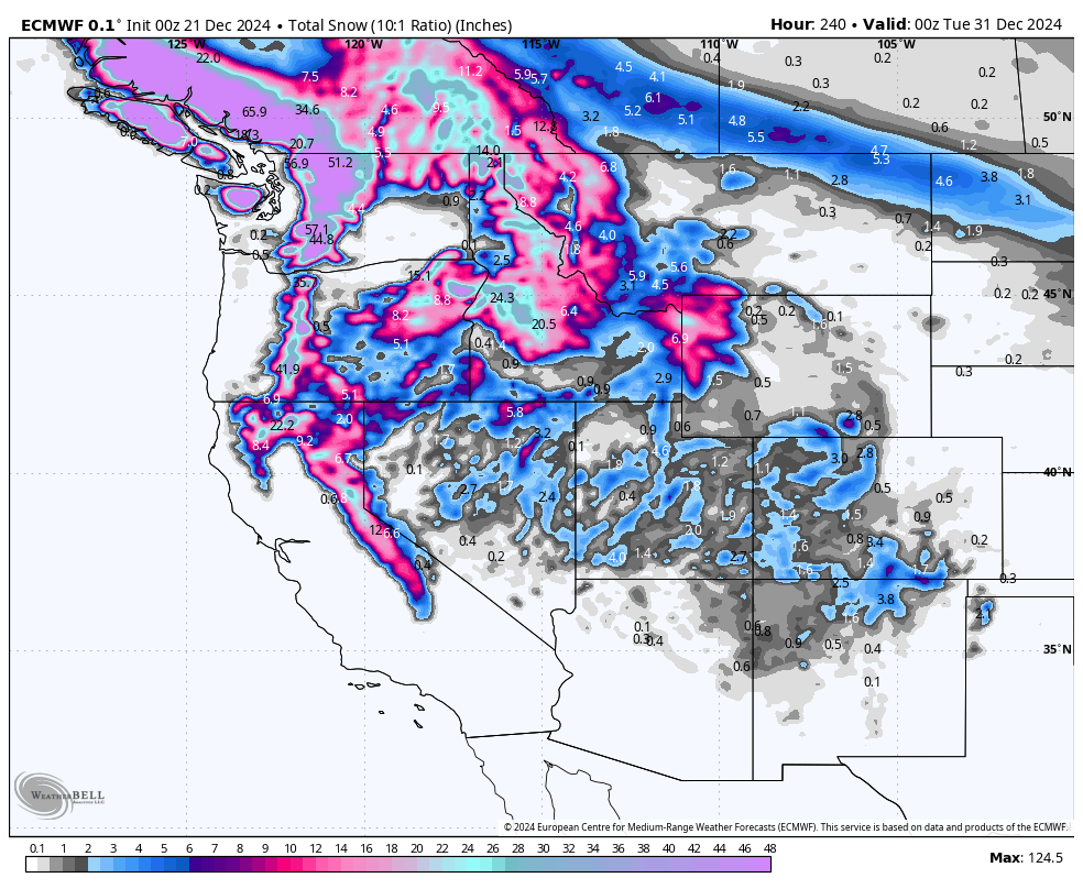
The 10-day forecast from the GFS (right) is currently quite a bit more bullish than the ECMWF (left)... it'll be interesting to see which solution wins as we get closer to these late-week storms! For now, don't get your hopes up and expect pretty minimal accumulations...


