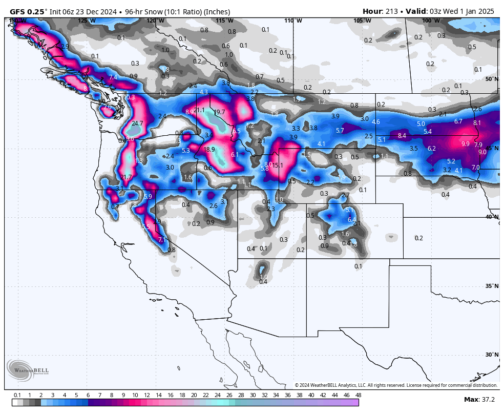
We are entering a very active period with multiple storms lined up in the Pacific. Teasers are happening early this week under warmer temperatures in most of the West. Temps have kept snow totals fairly low in the PNW including lower and mid elevations around Whistler. The action ramps up from midweek through the weekend with several feet of snow aimed at the PNW, and a few spots in the Rockies.
Below: Total snowfall through January 1st with multiple rounds of moisture this week extending into early next (Atmospheric River to slam the PNW).

Below: Whistler continues to rack up snowfall (Nearly continuous in the past 7 days) with warm temps on Monday morning putting down some low end totals on the snow stake. Lower elevations are seeing liquid precipitation Monday. Whitewater in interior BC has seen measurable snowfall for the last 11 straight days! Book your stay at Logden Lodge if you chase to Whitewater!

Christmas Eve Storm (Sierra).
Below: Storm #1, currently in the PNW drops south over the Sierra on the morning of Xmas Eve (Tuesday). This storm is weakening somewhat on the latest models and should land a quick 6-11 inches for the Sierra Crest (Western Tahoe) above 7,000 feet. Warm temps initially migrate to a colder flow on Tuesday (Snow levels drop to 5500 on the tail end of moisture).

Sierra Snow totals through late Tuesday (December 24).
Sierra Crest above 7,000- 9-12 inches
Eastern Sierra: 4-8 inches
Southern Sierra-Mammoth: 7-10 inches
Below: You can see the snow filling into the Sierra peaking from 5AM Tuesday through the early afternoon (It is a quick hitter but has a potent cold front that could increase hourly snow totals). (Date and time in upper right). Northern areas seem slightly favored. Ride powder from 1st chair Tuesday to last chair (Winds decreasing, and temps are dropping).

Below: The low splits and provides light to moderate snow in the Tetons Monday/Tuesday, while the southern branch over the Sierra takes aim at central to southern Utah, southern Colorado and northern New Mexico as noted on this map. We expect widespread totals in the 3-8 inch range.
Unfortunately, the Wasatch range is just south of the northern branch and a bit too far north of the moisture from the Sierra. Light snow is likely in the Wasatch while isolated pockets of 3-6 inches are possible in southern Colorado (Wolf Creek is favored) for Xmas. Taos will likely also grab light snow December 25/26 timeframe.
North/Central Colorado is stuck in a similar pattern with most of the action headed north (Steamboat might be an exception but there won't be any single deep period this week (Several periods of light snowfall). The January 4-5 storm looks better.

EXTENDED FORECAST- DEEP NUMBERS
Below Map; Snow totals from Thursday December 26 -December 30th (Monday).
Snowfall is filling in for Idaho and Wyoming from Thursday to Sunday this week initially hitting Idaho before the Tetons fire later in the period. Map: Thursday December 26 to Monday morning December 30th. We estimate widespread totals in the 2-4 foot range in some areas.
Brundage: 25-30 inches
Sun Valley: 9-15 inches
Lookout Pass: 12-15 inches
Selkirk Powder: 10-16 inches
JHMR: 20-28 inches
Targhee: 18-25 inches
Beaver Mountain: 8-12 inches (Sits in northern Utah).
Alta: 6-14 inches

Below: Snowfall totals ending Saturday December 28th. Additional snow will fall on Sunday/Monday (29th and 30th) as noted above.

Below: Total snowfall in the Pacific Northwest through Friday (December 27th) will be significant in many areas. The interior portions of BC will grab lower totals (6-10 while western areas grab 2-3 feet above 3500 feet (Slight cooling trend) midweek.

Snow Totals For the PNW through Saturday night December 28th.
Baker: 30-40 inches
Stevens Pass: 20-30 inches
Crystal: 25-40 inches
Whistler: 15-30 inches
Bachelor: 25-38 inches
Mission Ridge: 12-18 inches
Below: Sunday December 29-Tuesday-December 31st. Activity continues in the PNW and extends into a similar path as the preceding storms taking a northerly route. Areas of the PNW and northern Rockies will continue to rack up decent totals late next weekend and Into the following week.

Below: Current extended data shows the PNW might grab a break for the first few days of January before a strong system might slam the west in the January 4-7 timeframe. This appears to have potential to impact many areas of the west and could be a good signal for a wide area of the Rockies. Map is January 3rd to January 7th.

Please remember to support Powderchasers with a donation or sign up for the Concierge to support our forecasts.
Powderchaser Steve @powderchasersteve (Insta).


