Snow is falling heavily over many areas on Thursday evening. The Cottonwoods picked up 18 inches thus far with Little Cottonwood on Interlodge. As forecasted heavy snow (EPIC ALERT) has brought deep conditions to much of western Wyoming, Montana, and Utah with Colorado just getting onboard as of 2 PM Thursday. Even the northern San Juan Range in Colorado managed to score a foot of pow at Silverton Mountain as of 3 PM Thursday. I'm a bit surprised at that one.
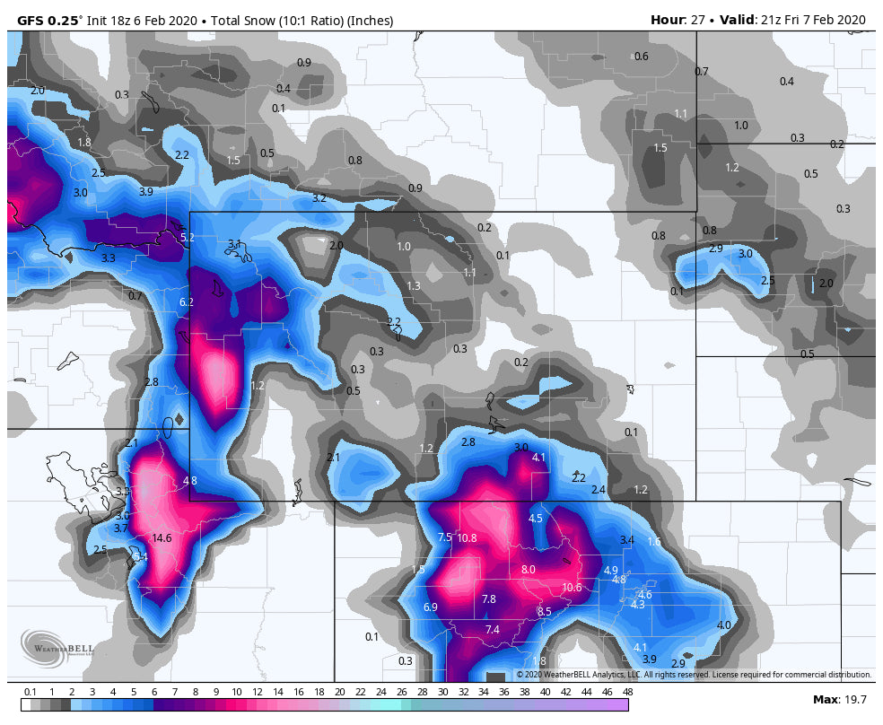
Heavy snow will continue well into Friday for most mountain ranges of central and northern Colorado. The I-70 corridor including Eagle and Summit extending north to Berthoud and Steamboat should see another 10-15 inches from 3 PM Thursday to Noon Friday. Chase Now! Some roads may be closed on Friday morning. I-70 East is closed as of late Thursday Eastbound near Vail Pass. Deep snow for nearly every resort Friday morning with perhaps slightly lower amounts south of I-70 (8-11). Remember to subtract the snow from Thursday while the lifts were open (2-3 at Steamboat, 5-7 at Vail when looking at cams). Snow will continue into Friday evening albeit lighter. Ride Pow all day Friday (Storm ski on deepness) and again Saturday with leftovers and some new snow. The deepest will be along I-70 or north. Aspen is going to be close!
In Utah, winds and warming temps have greatly increased AVY danger, especially above 8,000 feet. The models show winds remaining steady through Friday morning with another 7-15 inches for the Cottonwoods. Looking at Webcams at Park City it appears much less snow has fallen in these areas, perhaps due to the relatively warmer temps. I suspect it's deeper at the summits and especially the Canyons side who benefits with the NW wind flow.
The Tetons show strong confidence for additional snowfall Thursday night into Saturday. There is some discrepancy in amounts. One model shows 4-8 Thursday night and another at 3-5 with heavier snow south of Jackson (Alpine, Bondurant, Pinedale). You can ski in Pinedale (Deep) with the local mountain White Pine Ski area.
While epic amounts might not fall Thursday night the models show another burst of moderate or heavy snow for Saturday morning for the Tetons (AM Snow). It's likely that light to moderate snow continues into Saturday. Peak snowfall might happen mid-morning Friday on top of what falls Thursday night (3-8). Total additional snowfall for the Tetons through Saturday afternoon will be in the 9-15 inch range.
Southern Montana will continue to see moderate snowfall through Friday. Big Sky is favored being slightly south. Not sure if upper lifts will open?
Below: Total additional snowfall through Friday afternoon for UT, WY, MT, CO (Includes snow since noon on Thursday).

Finally, chases are imminent in the PNW where colder temps finally bring 12-15 inches to much of the Cascade Range. Warm temps and rain this week may impact the quality. My current thoughts are that Saturday will ride very well with good dumpage overnight Friday for Stevens, Baker, Snoqualmie, and Crystal. Light to moderate amounts is likely for the OR Cascades.
Below: Total 12 hour snowfall ending Saturday mid-morning for the Cascade Range with colder temps.

Please sign or donate to the Powder Concierge to support our forecasts. If you chasing POW from this forecast feed our bank for 1st chair.
This post is shortened due to an ongoing chase. Enjoy the Powder everyone. I hope to make it out somewhere for 1st chair or tram.
Powderchaser Steve


