SUMMARY POW
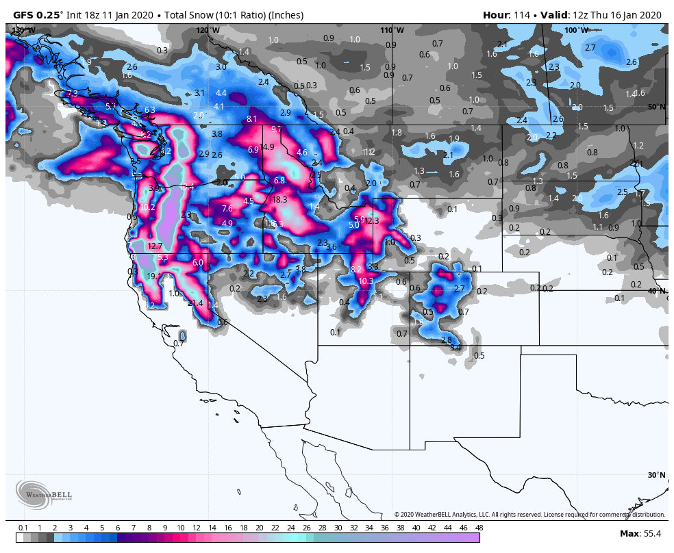
I have officially hoisted the epic alert! Cold temps and heavy snow continue to blast the west with the PNW in the cards for 2-3 feet by Monday. The Wasatch and Tetons keep scoring 5-10 inches every 12 hour period-through Wednesday. The Sierra may be deep on Thursday. Colorado gets leftovers this week with a large storm possible for the San Juan range late week. This is not a dream! Repeat! This is the real thing.
I chased to Crystal Mountain on Saturday with 10-14 inches of perfect density powder for opening chairs at 8:30 AM. Today was a perfect powder day with partial clearing by 11 AM and 100% of the Mountain opened by 1 PM including Southback hike terrain. Meanwhile, in the Tetons another 5-10 inches fell for Saturday morning and at press time of this post (Saturday evening), another 5-6 inches has already fallen. The Wasatch range scored 7-10 inches in just 4 hours on Saturday and it continues to snow albeit lighter intensity. NW flow should keep the snow falling in the Cottonwoods tonight (LLC is closed). Other favored locations are Powder Mountain, and the Canyons side of Park City (Likes NW winds). Sunday will be deep in many areas!
Where to chase? The next strong wave is just approaching the Cascades Saturday night. This system favors Stevens Pass, Alpental, and areas south towards White Pass. It also favors the Oregon range. Crystal is slightly shadowed by SW winds (Rainier). Expect 3-8 inches Saturday night and another 12-16 inches on Sunday (Storm Ski) for much of the Cascade Range. Even higher amounts are possible in Oregon. Snow showers will continue into Monday (Stevens convergence zone, Oregon Cascades get slammed). All areas will report decent amounts both Sunday and Monday (Sunday storm ski is the heaviest). Schweitzer in the Northern ID Panhandle will also get deep by late Sunday! Quality will be very high with cold temps in all of the Cascade Range. Low land snow near Seattle is possible on Sunday night!
In the Rockies, you can't' go wrong with western Idaho, Wasatch Range of Utah, and the Tetons. Expect steady periods of moderate snow through Wednesday, perhaps even Thursday. Highlights may come Sunday night into Monday and again on Tuesday morning. There are short breaks between waves (2 feet plus from Sunday to Wednesday). Park City scored 7-9 inches today (Canyons favored) with 10-12 inches in the Cottonwoods.
Colorado gets decent leftovers Sunday night into Monday with lighter amounts into midweek. Steamboat or areas west on I-70 (Beaver Creek, Aspen) may see the highest amounts. Crested Butte is likely to score as well. I will narrow that in on a later forecast. I don't see any deep 12 hour period. Perhaps Monday is the deepest day followed by
EXTENDED POW
Another system slides into Oregon in the Wednesday timeframe that takes aim on the Sierra for Thursday. This might be a good storm to watch (12-18 inches on the early take). That system should take a southerly route over the San Juan Range late next week also pushing moisture north into Central Colorado.
Below: Total snowfall from Saturday night through Thursday (Deep in many areas of the west. The Sierra snow will happen on Wednesday night.

SIGN UP FOR THE CONCIERGE FOR CUSTOM CHASE FORECASTS.
Powderchaser Steve


