Happy Thanksgiving.
It seems that nearly every Thanksgivng, Powderchasers is issuing a deep forecast! This year is no exception with a very wide area of the west receiving some much needed snowfall to the Sierra and Casades. Utah is going to grt crushed this weekend!
Models are all on track this morning for round #2 of snowfall for much of the west. The Sierra will see a significant increase of snow late Thursday through Friday. expect 12-18 inches of additional snow. for most of the Sierra. Winds will be very strong with lots of blowing and drifting snow. The last wave as we forecasted seemed to favor the southern zones of the Sierra. It's too early to confirm any data but from looking at the snow data sites at Mammoth it's possible that 10-11 inches fell just above the base levels. Areas will be much deeper by Friday afternoon especially on the northern side of the lake. I would put some favorites on resorts like Squaw or Sugar Bowl closer to I-80.
Here is a look at the snow cam at Kirkwood this morning as of 4 AM.

Snow will also ramp up in the Cascades tonight with an additional 10-18 inches over a wide area. West winds should produce an even spread of heavy snow from Baker, Stevens, Crystal, Alpental, Bachelor and Mount Hood. The east Cascades will see slightly lower amounts. Decent snowfall is also likely over Schweitzer Mountain (North Idaho near the WA border). Expect the deepest moisture late tonight through Friday morning.
In the Rockies, moderate snow will be likely in central and southern Montana (4-10) with heavier snow pushing into the Tetons of Wyoming through the Wasatch range in Utah. Models have me downgrading the Tetons slightly. Light snow will be falling over the Tetons through Friday before ramping up significantly late in the day.
Light to moderate snow will be falling in the Wasatch on Turkey Day with 4-9 inches likely by midnight. Warmer air arrives in Utah Friday (Increasing avalanche danger) with continued snowfall. Snowfall will increase significantly by mid to late morning Friday as the 2nd Sierra storm pushes into the Rockies.
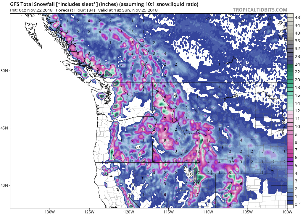
Colder air pushes into the Rockies Friday PM/Saturday with a significant increase of snowfall intensity and quality. The Tetons should grab an additional 7-10 inches with the Wasatch well into double digits. Teton Pass may be closed Saturday morning (Just a hunch, with strong winds and blowing snow). I am very confident for 12-20 inches for most of Utah including Park City, Powder, Snowbasin (slightly less), up to Logan. The Cottonwoods should score 20-30 inches as the system pushes east late Saturday night or early Sunday morning (Orographic showers may continue). The deepest totals may be reported at Alta or Snowbird, however, look for some impressive amounts at Powder Mountain who can score with NW winds and a storm system that will bullseye in the northern or central Wasatch.
As mentioned above, the Tetons will come up short of the Wasatch but still a respectable 7-10 inches late Friday/Saturday morning. It's possible higher amounts are found at the top of Teton Pass. Storm totals for the Tetons (Thursday-Sunday) will be higher with the light to moderate moisture that falls Turkey day and Friday.
The total snowfall amounts are increasing for Colorado through Saturday night. Light to moderate snow will be moving into this region tonight through Friday morning. 3-5 inches is likely in many areas west of the Divide. Higher amounts will be found near Steamboat and possibly south to Aspen. Silverton and Telluride will also see moderate snowfall tonight. Snow will develop again on Friday night and continue heavy at times through Saturday. Winds will be very strong with the passage of a cold front. This may impact lifts at higher terrain.
The most significant amounts will likely be found just north of Steamboat (Buffalo Pass), Rabbit Ears, extending south into the Flat Tops, and Elk Range (Aspen/Snowmass). Crested Butte may score with west winds initially and a stream of moisture extending near Irwin Lodge to the CB. Beaver Creek is a solid contender on the western side of Eagle County. Expect a wide area of 9-18 inches in these locations. If I were chasing pow, my hot list would be Steamboat, Aspen, Crested Butte, Beaver Creek with wildcards going to Vail, Copper, and Telluride. The wildcard list is likely to score an additional 6-12 inches through Saturday night. Best chase times will be storm ski Saturday (Windy) with some leftover powder that falls into Sunday morning. Areas further east into Summit and Grand Counties may see lower amounts.
Below: Total snowfall through Sunday for much of the west. Image: Tropical Tidbits.

Extended Forecast
The long-range forecast shows an unsettled pattern continuing for the west. Warmer temps and heavy moisture may impact the Cascades early next week (High elevation snowfall with rain at the bases). Colder temps mid-week will usher in additional snowfall for the Rockies and Cascades. Significant moisture is possible late next week that may impact a wide area of the west including the Sierra. Confidence is high on continued moisture but low on the exact highlights.
Avalanche conditions will be rising this week! Strong winds, warming periods between the 2 storms and some unstable layers will exist in many areas. Always check Avalanche conditions before venturing out in the backcountry! \"Know before you go\"
Ride Pow and enjoy your Turkey! Stay safe on the roads!
Powderchaser Steve


