Overview
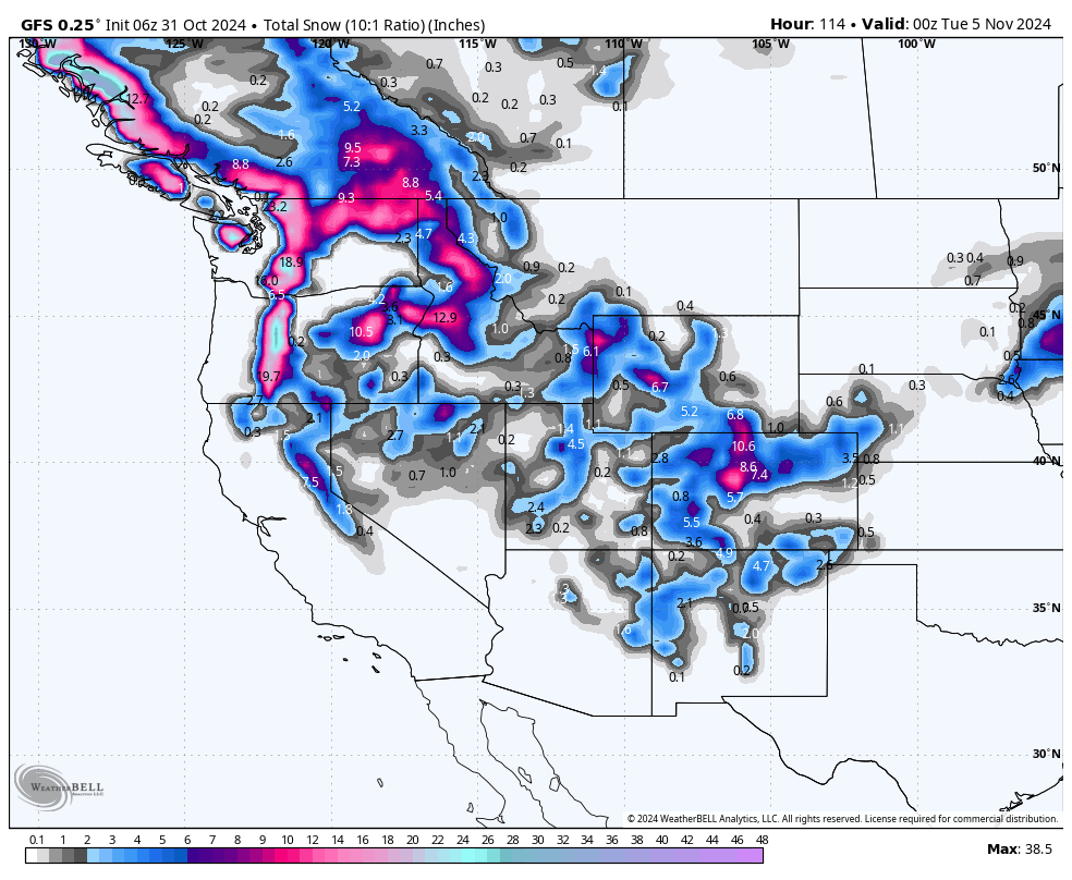
Happy Halloween! This week, we're looking at three storm systems hammering all of the West, with a fourth lining up for next weekend. Expect an active pattern with plenty of snowfall across the mountains, making for an exciting few days ahead.
Prior storm summary
The last storm to sweep through the west brought very solid accumulations to parts of Utah & Colorado over the last 3 days. The San Juans saw 10-24" of accumulation, with 12" at Telluride and 15" at Wolf Creek. Central CO saw 5-12" of snow. Steamboat picked up 5.
In Utah, resorts in the Cottonwoods saw 6-10" at PC/DV saw 3-6".
Current Storm (Thursday)
The first storm in our forecast is already underway, bringing some light snowfall to parts of the West this morning (Thursday). Snow is actively falling across the Cascades, Sierra, Idaho, and northern Nevada. This storm is setting the stage for a dynamic, fast-moving series of systems that will keep the snow flying over the next several days, especially at the upper elevations.
By Thursday evening, most of California and Nevada will see a decrease in snowfall activity, while the Tetons will be filling in as moisture pushes through Idaho into southern Montana and Wyoming (light to moderate totals).
Thursday Night: New Storm for the PNW

Thursday night into Friday morning, a new storm will move into the Pacific Northwest, bringing snow to Washington and Oregon. This system will mainly stay confined to the PNW until Friday night, when it starts slipping southward into California and eastward into Idaho. Snowfall will ramp up late Friday into Saturday across the Cascades, with notable totals expected, especially at higher elevations (above 4,000 feet).
Unfortunately densities will be a bit upside down with snow levels in the Cascades starting out from 3,500-4K Thursday and rising to near 5K or higher on Friday (warmest temps in Oregon). Significant upper mountain snow fall is likely, especially in the central Oregon Cascades (Mt Bachelor) and extending north into southern Washington (White Pass, Crystal). Temps in Washington will remain slightly cooler. Areas north towards Stevens and Mt Baker will see light to moderate totals.
Saturday Evening: Snow Reaches the Tetons and Wasatch

By Saturday evening, moisture will surge southeast, bringing snow to the Tetons and Wasatch. This looks like a decent hit for Utah and the Tetons, with the Cottonwoods and upper areas of the Tetons seeing 5-10 inches.
Sponsor Alert: Beaver Mountain located in northern Utah has been our longest running sponsor. Please support locally run family ski areas. Beaver can grab deep dumps when storms set up over the northern Wasatch Range. Beaver is having it's annual yard sale of gear this Saturday November 2nd (Logan office parking lot) with tons of gear.
Monday: Another System for the PNW
Monday brings yet another system into the PNW. This one is more focused on Washington, particularly the northern Cascades. Mt. Baker, Stevens Pass, and Alpental will all receive a solid shot of snow, with Crystal Mountain benefiting once again from its elevation advantage. The storm will then slide east, impacting Idaho, Montana, and Wyoming. However, it is expected to weaken before reaching far enough south to benefit Utah, California, or Colorado. Most of the action stays up north with this one.
Expected Snow Totals
PNW Totals by Monday Morning (Mid or higher peaks of the Ski Areas)
-
Mt. Baker: 6-10"
-
Stevens Pass: 6-12"
-
Alpental: 5-10"
-
Crystal Mountain: 10-18" (elevation matters!)
-
Timberline: 24-36"
-
Mt. Bachelor: 25-35"
PNW Totals by Tuesday Evening (After Monday's System):
-
Mt. Baker: 15-25"
-
Stevens Pass: 12-18"
-
Alpental: 12-20"
-
Crystal Mountain: 16-24"
-
Timberline: 30-40"
-
Mt. Bachelor: 25-35"
California by Sunday Morning:
-
West Shore (Sugar Bowl, Palisades, Kirkwood): 4-9"
-
Central Tahoe (Northstar, Homewood): 3-7"
-
Eastern Tahoe (Mt. Rose, Heavenly): 4-7"
- Mammoth: 2-5"
Utah and Wyoming by Monday Night (NOTE: more snow will arrive Tuesday morning, but it's too early to pin down totals):
-
Cottonwood Resorts: 6-12"
- Tetons-6-12"
-
Park City/Deer Valley: 4-8"
-
Eagle Point: 6-10"
Colorado by Tuesday Night (NOTE: a little more snow is possible on Tuesday evening, but it's still too far out to say for sure):
-
Steamboat: 4-9"
-
Winter Park: 8-12"
-
Arapahoe Basin/Loveland: 6-10"
-
Breckenridge/Copper Mountain: 3-6"
-
Vail/Beaver Creek: 4-8"
-
Aspen/Snowmass: 6-12" for Snowmass/Highlands, 4-8" for Ajax/Buttermilk
-
Crested Butte: 3-7"
-
Monarch: 6-10"
-
Telluride: 6-12"
-
Wolf Creek: 9-15"
Looking Ahead
After these storms, the models are showing significant variability regarding what's next. Most are hinting at another system starting in the PNW around next Saturday, November 9th. This upcoming storm looks a bit warmer, and we might see a mixed bag of snow and rain, particularly at lower elevations in Washington. Stay tuned for updates as we track this one—it's still early, and things could change.
Please support Powderchasers with a donation, Merch purchase, or sign up for our custom Concierge Powder Forecast Package where we provide 1:1 phone and email support to keep you in the deepest locations possible. Outside Magazine listed Powderchasers as in the top 3 sites with the custom concierge program. This supports us and keeps you chasing the deepest snow all winter.
You can follow us on instagram @powderchasers and FB.


