Summary: Systems continue to barrage the Pacific Northwest with moderate to heavy snowfall above 4,000 feet. Snow levels decrease with 2 more waves through Tuesday. The Rockies grab a moderate event this weekend into Monday with a stronger system due for the PNW early next week that might track and stall over the 4 corners.
I'm in the Pacific Northwest posting from Seattle on Saturday morning. Snow totals in the Cascade ranges have been decent with generally 10-15 inches at many resorts favoring the southern Cascades of Washington and most of Oregon and the interior northern regions of Idaho. Selkirk Powder Guides in northern Idaho likely has seen significant snowfall.
Below: Mt Bachelor on Saturday morning. Additional snow is headed your way.

The previous 2 days' snowfall totals
Crystal: 10 inches
Timberline Lodge: 16 inches
Stevens Pass: 8 inches
Bachelor: 14 inches
Schweitzer Ski area: 15-18 inches (Upper elevations).
The pattern continues to be very wet with a moderate system and cooling trend due for Saturday/Sunday and an additional 3-7 inches of snow for many ski areas. Higher amounts are possible in Oregon. Sun breaks are likely in the PNW on Sunday.
The Rockies grab the leftovers with the Sierra (1-4) being on the southern and western fringe of any heavy snowfall. Highlights in the Rockies appear to be in northern Idaho (Schweitzer, Selkirk Powder, Panhandle resorts) extending into the Tetons, Wasatch, and most of northern and central Colorado including the Front Range.
Some Forecasted Totals- Saturday-Monday
Schweitzer: 12 inches
Jackson Hole: 8 inches
Targhee: 9 inches
Alta: 9 inches
Breckenridge: 9 inches
Loveland: 9 inches
Vail: 8 inches
Big Sky: 5 inches
Angle Fire: 6 inches
Ski Santa Fe: 9 inches
Bottom Line Rockies: Moderate event with decent orographic components (WInd direction from the NW for the Cottonwoods), decaying moisture with a general trend of 5-10 inches over a widespread area from Idaho to Colorado. Colorado grabs some upslope components (Winds from the N and NE) that will push some decent totals on the Divide (Loveland, Berthoud Pass, A-Basin).
Below: Precipitation totals through late Sunday highlighting nearly 3/4 inch of water. With colder temps on this storm (-10C at 10K) snow ratios will be better than previous waves. This could result in 6-10 inches of snowfall in many areas of the higher peaks of the Tetons and the northern and southern Wasatch. The Cottonwoods might end up on the higher spectrum of the forecast (7-12) with decent totals towards Powder Mountain in the northern regions of the Wasatch. Peak snowfall will be later Saturday night into Sunday morning.

Below: Decent wind direction for orographic lift for most of the northern and southern Wasatch ranges including the Canyons side of Park City and Parleys Summit.

Below: Snowfall in Colorado peaks from Sunday afternoon to Monday. This system favors the Front Range resorts as opposed to previous systems. Most of the central mountains on both sides of I-70 should grab 5-10 inches into Monday morning. Areas on the eastern side or along the Divide might see higher totals. New Mexico also could do well with some upslope easterly components favoring Ski Santa Fe and Angel Fire.

Some light snow is also likely in the Front Range Metro areas of Colorado by Monday morning. Get your snow tires on and check our sponsor specials here at the Tire Rack (They will ship to Discount Tire).
Extended Deep Pow
Below: Significant snowfall is possible for the Pacific Northwest early next week November 4-5. this system will favor the central and northern Cascades of Washington from the I-90 corridor into western BC including Whistler. Crystal further south will see moderate snow while much less falls in Oregon (Flip-flopping from the last storm).

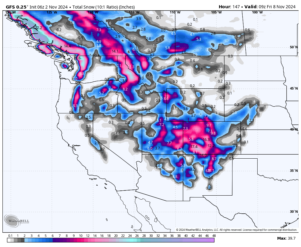
Below: Low pressure from the strong system in the PNW early next week drops south over the Rockies and cuts off over the 4 corners. This will bring decent snowfall to many regions of the west.

Below: Track of next week's storm with 24-hour snowfall increments below pushing in deep for the northern areas of the PNW and bringing in some decent totals to most of the intermountain west). Some higher totals are possible in the San Juan range as the low cuts off and stalls by Wednesday in the 4 corners.

Please support Powderchasers with a donation, Merch purchase, or sign up for our custom Concierge Powder Forecast Package where we provide 1:1 phone and email support to keep you in the deepest locations possible. Outside Magazine listed Powderchasers as in the top 3 sites with the custom concierge program. This supports us and keeps you chasing the deepest snow all winter.
You can follow us on instagram @powderchasers and FB.
Enjoy the powder, everyone!
Powderchaser Steve @powderchasersteve


