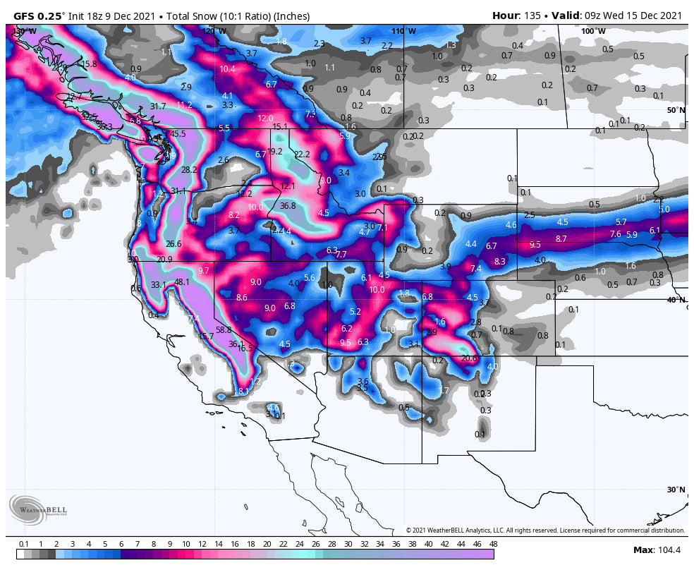
There is a ton to talk about so I will try to keep this concise. The bottom line is that very deep snow will bring game changing conditions to the west in the next 7 days. Deep snow is currently falling over the Central Rockies of Utah and Colorado. The weekend will bring a deep storm to the PNW, Canada and eventually the Sierra. Several feet of powder will fall in the extended forecast.
Thursday brought up to 13 inches to areas of the Wasatch and central Colorado.
Amounts as of Thursday evening.
Crested Butte: 13 inches
Alta: 13 inches
Park City 11-12 inches
Wolf Creek: 8 inches
Telluride 4-6
Aspen Highlands- 6 inches
Breckenridge 6 inches
In most areas it is still snowing with the models highlighting Colorado for the deepest storm totals through Friday. It's likely that the central mountains including Crested Butte, Aspen Highlands (Wildcard), and Silverton score another 9-14 inches. Further north towards I-70 snow will increase as SW winds veer to the W, NW around midnight Thursday. The snow thus far has been dense (Good for base building) and avalanche conditions are rapidly on the rise in some areas. Current models are showing additional snowfall of double digits for the central and perhaps the southern mountains with 5-10 along the core of I-70 (The further east may see less). Steamboat should also deliver decent amounts into Friday with the favored wind direction.
Below: Decent amounts for Colorado Thursday night to Friday with the highest amounts for the central mountains extending up to Steamboat with less along the I-70 corridor. Some surprises are possible near Vail Pass or SW towards Aspen. Also Breck often over performs the models with NW flow. the southern mountains will continue to see snowfall but it might decrease a bit around midnight. Telluride will continue to do well with the NW wind shift and could be deep by Friday.

In Utah, 1st tram at Snowbird Thursday delivered a nearly bottomless smooth sensation with light fluff on top. They ended the day with 13 inches and it is still snowing lightly.
Below: Alta Utah- Photo: @powderchasersteve via instagram

The Wasatch will continue to see light snow showers Thursday night favoring the Cottonwood Canyons albeit light intensity. Models are showing an uptick of snowfall for Friday morning picking up around 5AM with a burst of perhaps another 3-7 inches by 11AM. This may also impact the Park City Resorts with slightly less. Northern Utah was grazed with the last storm providing only light to moderate amounts for Powder Mountain (3-7). Warmer temps and the location of the most intense bands of snow really hit the I-80 resorts and areas south the hardest. There is more snow in the extended forecast for the Wasatch. Hopefully you have your snow tires on! Update: Ski Eagle Point in southern Utah is up to 21 inches as of Thursday evening.
In the Cascades up to 8 inches fell favoring Crystal and Baker. Things will ramp up significantly for the weekend with several feet possible. Interior WA and northern Idaho will also score decent amounts.
Below: Total snowfall in the PNW and western BC with the upcoming weekend storm. 2-3 feet possible for the western sections and up to 15 inches likely for Selkirk Powder in Northern Idaho (Might see higher amounts).

The Sierra grabbed moderate snowfall favoring the southern mountains (Mammoth reported 8-9 inches Thursday morning).
In the extended forecast a MEGA storm will start in the Pacific Northwest and western Canada Friday night to Sunday (1-2 feet along the spine of the Cascades and western BC (Whistler). This storm will migrate over the Sierra by Tuesday with the model data pumping out 3-5 feet! This will take California from 0 to hero in just a few days. From the Sierra its likely with Southerly flow some decent snow is likely for the Sawtooth near Sun Valley before moving over the northern Rockies (Midweek storm). Models will change so stay tuned to Powderchasers.
Below: MEGA dump for the west with total snowfall from Thursday night to next Wednesday. This is a Ski Area Dream for many areas.

This is all great news! Thanks for following Powderchasers. If you want to chase powder to the deepest resorts join our concierge program for custom chase forecasts. If you want to Heli Ski in Alaska this year there are still some spots open for the 1st 3 weeks of March at our partner Alaska Backcountry Guides. If you book with them, you will automatically get a free concierge package by mentioning Powderchasers.
Enjoy the powder everyone! Powderchaser Steve @powderchasersteve via Instagram


