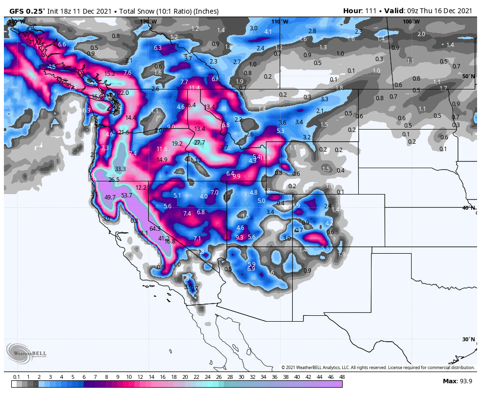
Our first Snorkel Alert for the season! ULLR our snow god is back! California is going to get the full burial this week with 2 storms on tap. The Western areas of BC and the Cascades of Oregon and Washington will see 3 feet or more in the next 48 hours. The action will move east impacting a wide area of Idaho, Northern Montana, and eventually into the Tetons, Wasatch and Colorado.
The departing storm in the Rockies performed very close to our forecast. We highlighted the southern and central mountains of Colorado (Crested Butte, Telluride, Purgatory, Wolf Creek, Aspen) and put Steamboat on the list with good SW flow pushing moisture to the northern sections of the State. The western sections of I-70 out performed (Vail) the east (Summit County). Storm totals in many of our highlighted areas exceeded 2 feet (Aspen, CB, Purgatory, Wolf, Telluride) with Vail around 13 inches. In Utah, 25 inches fell at Snowbird with 1.5 inches of water. Park City grabbed just over a foot of powder, with higher amounts possible on the Canyons side. Our partner, Arizona Snowbowl nabbed 18 inches of pow on Friday! Bottom Line: Great storm but conditions are still early season at many resorts with a few places currently in our top list for mid winter riding. Its unfortunate that the eastern side of the I-70 corridor and resorts further north in Utah and Wyoming/Montana did not do better.
The hype for deep powder is focussed on the western US and Canada for the next 5 days. Significant snowfall is now falling over western BC and most of the Cascade Range. What's really good about this storm, is that widespread amounts of 2-3 feet will fall from north to south. Mt Baker might out perform with the winds from the SW initially. Resorts further south including Crystal, White Pass, Timberline, Bachelor, will do better in the late Saturday to Sunday timeframe. This storm will be a game changer and allow most places to open. The interior Cascades should grab a foot or more and areas north towards Sandpoint will see higher amounts (Selkirk Powder Guides). Heavy dumps are also likely for northern Montana near Whitefish!
Below: Total snowfall for Stevens Pass is impressive on the ensemble averages from the University of Utah (Tight lines= good consensus for 20 plus inches of snow).

Below: Current telemetry showing 20 inches thus far at Mt Baker Ski Area as of 5 AM Saturday and much more to come!

Below: Whistler Web cam early Saturday with snow continuing albeit intensity might lighten slightly during the day before increasing into Sunday. Winds are very strong at the upper elevations so expect extensive upper mountain delays or closures.

Sierra/Rockies
The snorkel alert will be in full effect for the Sierra beginning Sunday and ending Tuesday (Peaking Monday- Tuesday) with another round of snow likely Wednesday/Thursday. There might be a short break late Tuesday. Snowfall amounts of 5-6 feet are with very high confidence next week with some isolated locations on the Crest picking up higher amounts. We could see some 75 inch plus snow totals! We think ULLR is living in the Northwest right now but quickly setting up camp over the Tahoe (Look for his van with large ULLR stickers and an older guy with a deep beard). Bottom Line: Game changer for the Sierra, areas of Idaho, and perhaps Montana coming up with some surprises. Lot of things can go wrong in your chase with this storm (Road closures, resort delays, etc.).
Below: Total snowfall averaging all ensemble models showing amounts in the 60-80 inch range for Kirkwood early next week.

Winds are from the S, SW that will push significant moisture into certain areas of Idaho that will be deep by Tuesday and Wednesday (Sawtooth's and northern regions). Central Idaho (Brundage, Tamarack) and areas of the panhandle near the Montana border (Missoula) should also see decent snowfall. Whitefish further north is also highlighted for some deep snow. If you want to chase powder with us, join the Concierge program as we are formulating plans for a 2-3 State chase right now.
Below: Total snowfall through Wednesday morning for the Northern Rockies and Panhandle of Idaho.

The models advertise moisture pushing north into the Tetons early next week and extending into southern Montana (Big Sky might finally get a dump). Utah will also see some snow that might favor slightly higher amounts near the Idaho border near Beaver Mountain. SW flow initially turns NW behind the initial surge of moisture. The models show decent amounts in southern Utah extending into the San Juan Range of Colorado. Arizona Snowbowl is also likely to benefit by Wednesday morning. Some moisture will push north in Colorado especially with the NW wind shift at some point by Wednesday along the I-70 corridor (Could favor the western side of the State again).
Below: Total snowfall for UT/CO/AZ/NM focused on the late Tuesday night to Wednesday timeframe. Focus might be in the San Juan Range with some decent snow also noted in northern Utah.

Below: Deep low pressure over the west coast Monday/Tuesday pushing moisture north into areas of Idaho/Montana initially.

There is another system that appears to impact the west late next week albeit weaker, that might move into the Sierra by Thursday or Friday. Please join our Concierge program if you want to deepest powder (We are on the chase right now). If you want to Heli Ski in Alaska we highly recommend Alaska Backcountry Guides who still has only a few weeks left in March. Any new bookings will provide you a free concierge package from Powderchasers. They provide top notch service and will get you pitted out in the deep AK snow.
Enjoy the POW everyone! You can follow my photographic and travel adventure on Instagram @powderchasersteve


