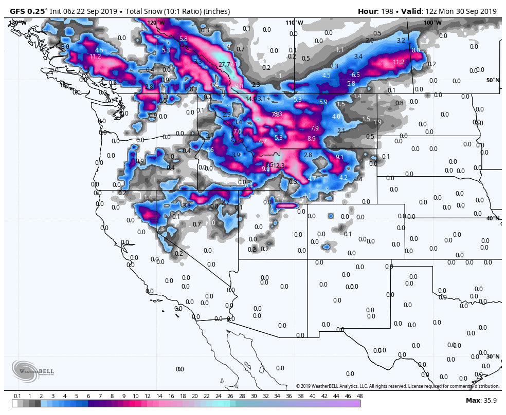
Fall is going to come in with what appears to be a return of a winter pattern, with the models hinting at a signifcant push of unseasnably cold air and snowfall. Its possible that 1-2 feet of snow fall in some isolated areas of the northern Rockies and measurable amounts filtering south even into the Sierra by the weekend.
The preceeding 3 days has seen a brush of winter that we forecasted early last week by Powderchasers. The front came in as forecasted setting up over Wyoming and southern Montana dumping up to 8 inches at the summit of Jackson Hole Mountain Resort and Grand Targhee. Targhee appeared to have 2-3 inches at the base while JHMR scored snow only at upper elevations. Below: Grand Targhee Base area - Snowing heavily Friday afternoon - Webcam- Via Powderchasers
 \\
\\
Temps dropped late Friday night and brought some of the first accumulating snowfall to Teton Pass albeit light.

Some light snow was reported in the southern Montana mountains with heavy snow closing Beartooth Pass in Montana Friday afternoon. The front also brought a quick burst of snowfall for the Wasatch with what appeared to be 2-3 inches in many areas including the upper elevations of Park City on Friday morning.
Below: Park City Mountain Resort - Friday morning (Trails were still lightly snow covered up upper elevations on Saturday).

The week ahead will likley pose a very interesting scenerio of very cold air pushing in from Canada and the Pacific Northwest. The models this far out sometimes struggle on exact positioning of the next system so updates will be posted during the week. What we are confident on, is that temps will drop 15-20 degrees late this week and it's likley heavy snow will be falling over much of Alberta and perhaps the interior of BC by Thursday (Whistler may also see it's first snowfall- Wildcard). That sytem will push south late in the week impacting Montana and Wyoming as the low sets up somewhere over Nevada by Friday. A broad area of snow may be falling in the many of the western States inlcuding the northern Sierra by the weekend. The heaviest amounts by late next weekend may end up in the northern sections of the Rockies however many areas are going to see appreciable snow in the west.
Below: Total snowfall through Sunday (Models this far out are very subject to change). Courtesy of Weatherbell.

Temperatures will plummet beginning Thursday afternoon in Montana and eventually into much of the west by the weekend. its posible that many areas of the west see their first valley snowfall of the season as the snow level drops to as low as 5,500 feet. Expect roads to become snow covered in many areas especially at mid or upper elevations.
Below: Temps at 9800 feet well below freezing (Celcius) by Saturday in much of the west. That cold front begins in Montana on Thursday night.

Stay tuned to Powderchasers.com on the web and don't forget to sign up for the Powder Alerts and our Concierge Service .


